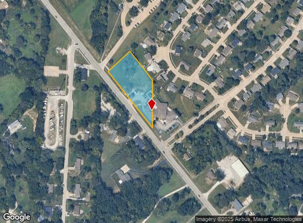
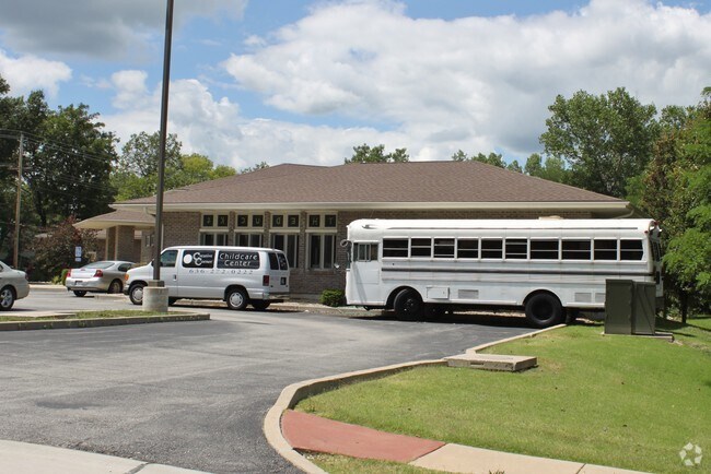
Property Record
1075 Highway P, O Fallon, MO 63366

NEARBY LISTINGS FOR SALE OR LEASE
Property Detail
1075 Highway P
St. Louis, MO-IL
PT E PT NE 1/4
2-0043-S013-00-0001.0000000
St. Charles
Commercialnec
Missouri
2024
1
2025
1.52 AC
311801
Outer St Charles Cnty
10,558 SF
St. Louis
DEMOGRAPHICS near 1075 Highway P
1 Mile
3 Mile
5 Mile
2024 Total Population
4,330
32,704
91,014
2029 Population
4,635
34,673
96,666
Pop Growth 2024-2029
+ 7.04%
+ 6.02%
+ 6.21%
Average Age
39
40
40
2024 Total Households
1,521
12,813
34,458
HH Growth 2024-2029
+ 7.10%
+ 6.03%
+ 6.22%
Median Household Inc
$101,807
$84,609
$95,352
Avg Household Size
2.80
2.50
2.60
2024 Avg HH Vehicles
2.00
2.00
2.00
Median Home Value
$300,257
$265,994
$275,201
Median Year Built
1997
1999
1997
Nearby Places
Map Layers
Map Styles
 Street
 Aerial
- Restaurants
- Banks
- Shops
- Fitness
- Groceries
PUBLIC TRANSPORTATION
AIRPORT
St Louis Lambert International
DRIVE
WALK
Distance
St Louis Lambert International
36 min
25.7 mi
Freight Ports
Port Milwaukee
DRIVE
WALK
Distance
Port Milwaukee
456 min
398.8 mi
Nearby Properties
Address
Land Use
TOTAL SIZE
Lot Size
Zoning
Address
Land Use
TOTAL SIZE
Lot Size
Zoning
254,435 SF
16.57 AC
Address
Land Use
TOTAL SIZE
Lot Size
Zoning
36,438 SF
2.08 AC
AC4
Address
Land Use
TOTAL SIZE
Lot Size
Zoning
251,169 SF
20.19 AC
Address
Land Use
TOTAL SIZE
Lot Size
Zoning
210,095 SF
12.29 AC
AE9
Address
Land Use
TOTAL SIZE
Lot Size
Zoning
147,526 SF
7.51 AC
AE8
Address
Land Use
TOTAL SIZE
Lot Size
Zoning
57.96 AC
Address
Land Use
TOTAL SIZE
Lot Size
Zoning
1,484 SF
90.24 AC
Address
Land Use
TOTAL SIZE
Lot Size
Zoning
35.34 AC
Address
Land Use
TOTAL SIZE
Lot Size
Zoning
69,500 SF
9.39 AC
Address
Land Use
TOTAL SIZE
Lot Size
Zoning
55,323 SF
8.44 AC
AC4
Address
Land Use
TOTAL SIZE
Lot Size
Zoning
13.97 AC
Address
Land Use
TOTAL SIZE
Lot Size
Zoning
Address
Land Use
TOTAL SIZE
Lot Size
Zoning
97,000 SF
6.25 AC
Address
Land Use
TOTAL SIZE
Lot Size
Zoning
122,599 SF
5.24 AC
Address
Land Use
TOTAL SIZE
Lot Size
Zoning
104,309 SF
7.99 AC
AA1
Address
Land Use
TOTAL SIZE
Lot Size
Zoning
29,680 SF
2.76 AC
Address
Land Use
TOTAL SIZE
Lot Size
Zoning
34,160 SF
4.07 AC
AB3
Address
Land Use
TOTAL SIZE
Lot Size
Zoning
644 SF
62 AC
AB6
Address
Land Use
TOTAL SIZE
Lot Size
Zoning
103,538 SF
8.07 AC
AC3
Address
Land Use
TOTAL SIZE
Lot Size
Zoning
26.59 AC
AE9
Address
Land Use
TOTAL SIZE
Lot Size
Zoning
28,265 SF
2.21 AC
AB3
Address
Land Use
TOTAL SIZE
Lot Size
Zoning
102,938 SF
10.03 AC
Address
Land Use
TOTAL SIZE
Lot Size
Zoning
66,216 SF
7.04 AC
AB2
Address
Land Use
TOTAL SIZE
Lot Size
Zoning
101,805 SF
8.99 AC
Address
Land Use
TOTAL SIZE
Lot Size
Zoning
58,560 SF
7.95 AC
Address
Land Use
TOTAL SIZE
Lot Size
Zoning
8.78 AC
AE9
Address
Land Use
TOTAL SIZE
Lot Size
Zoning
14.72 AC
AD9
Address
Land Use
TOTAL SIZE
Lot Size
Zoning
55,300 SF
4.16 AC
AB3
Address
Land Use
TOTAL SIZE
Lot Size
Zoning
75,210 SF
5.83 AC
Address
Land Use
TOTAL SIZE
Lot Size
Zoning
82,350 SF
4.83 AC
The World's #1 Commercial Real Estate Marketplace
Connect with us
© 2025 CoStar Group
The information above has been obtained from sources believed reliable. While we do not doubt its accuracy we have not verified it and make no guarantee, warranty or representation about it. It is your responsibility to independently confirm its accuracy and completeness. Any projections, opinions, assumptions, or estimates used are for example only and do not represent the current or future performance of the property. The value of this transaction to you depends on tax and other factors which should be evaluated by your tax, financial, and legal advisors. You and your advisors should conduct a careful, independent investigation of the property to determine to your satisfaction the suitability of the property for your needs.