Property Record
1075 N 2000 W, Ogden, UT 84404
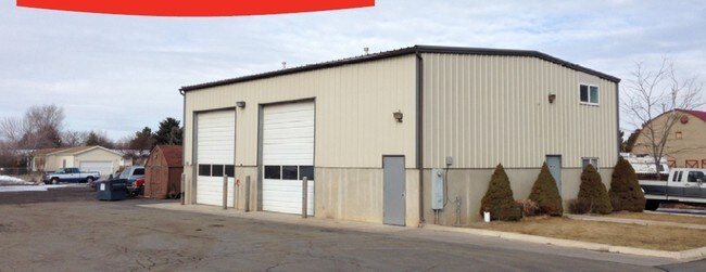


Property Detail
1075 N 2000 W
Ogden, UT
PART OF THE NORTHEAST QUARTER OF SECTION 11, AND THE SOUTHEAS QUARTER OF SECTION 2, TOWNSHIP 6 NORTH, RANGE 2 WEST, SALT LAKE
15-150-0004
Weber
Autorepair
Utah
B and X Area of moderate flood hazard, usually the area between the limits of the 100-year and 500-year floods.
97
2025
1 AC
2025
Davis North
210407
Salt Lake City
2,000 SF
NEARBY LISTINGS FOR SALE OR LEASE
DEMOGRAPHICS near 1075 N 2000 W
1 mile
3 mile
5 mile
2025 Total Population
2,539
31,856
115,741
2030 Population
2,639
33,376
121,050
Pop Growth 2025-2030
+ 3.94%
+ 4.77%
+ 4.59%
Average Age
41
36
36
2025 Total Households
850
10,018
38,922
HH Growth 2025-2030
+ 4.24%
+ 5.07%
+ 4.83%
Median Household Inc
$118,220
$95,950
$88,752
Avg Household Size
3.00
3.10
2.90
2025 Avg HH Vehicles
3.00
2.00
2.00
Median Home Value
$531,327
$466,948
$443,503
Median Year Built
1997
2003
1994
Nearby Places
Map Layers
Map Styles
 Street
 Aerial
Layers
 Traffic
 Biking
Places
Listings with unknown addresses are not visible on the map
- Restaurants
- Banks
- Shops
- Fitness
- Groceries
PUBLIC TRANSPORTATION
COMMUTER RAIL
Ogden (FrontRunner North - Utah Transit Authority (UTA))
Drive
Walk
Distance
Ogden (FrontRunner North - Utah Transit Authority (UTA))
10 min
5.9 mi
Roy (FrontRunner North - Utah Transit Authority (UTA))
Drive
Walk
Distance
Roy (FrontRunner North - Utah Transit Authority (UTA))
12 min
6.8 mi
Freight Ports
Port of Stockton
Drive
Walk
Distance
Port of Stockton
751 min
733.0 mi
Nearby Properties
Address
Land Use
TOTAL SIZE
Lot Size
Zoning
Address
Land Use
TOTAL SIZE
Lot Size
Zoning
1,154,674 SF
133.48 AC
Address
Land Use
TOTAL SIZE
Lot Size
Zoning
1,001,933 SF
40.73 AC
Address
Land Use
TOTAL SIZE
Lot Size
Zoning
111,832 SF
24.92 AC
Address
Land Use
TOTAL SIZE
Lot Size
Zoning
104,868 SF
22.96 AC
Address
Land Use
TOTAL SIZE
Lot Size
Zoning
292,940 SF
17.83 AC
Address
Land Use
TOTAL SIZE
Lot Size
Zoning
149,400 SF
26.88 AC
Address
Land Use
TOTAL SIZE
Lot Size
Zoning
183,172 SF
47.62 AC
Address
Land Use
TOTAL SIZE
Lot Size
Zoning
292,900 SF
14.54 AC
Address
Land Use
TOTAL SIZE
Lot Size
Zoning
264,373 SF
13.52 AC
Address
Land Use
TOTAL SIZE
Lot Size
Zoning
596 SF
8.08 AC
Address
Land Use
TOTAL SIZE
Lot Size
Zoning
202,499 SF
20.48 AC
Address
Land Use
TOTAL SIZE
Lot Size
Zoning
1,840 SF
127.86 AC
Address
Land Use
TOTAL SIZE
Lot Size
Zoning
3,936 SF
46.16 AC
Address
Land Use
TOTAL SIZE
Lot Size
Zoning
247,962 SF
19.14 AC
Address
Land Use
TOTAL SIZE
Lot Size
Zoning
7,632 SF
6.87 AC
Address
Land Use
TOTAL SIZE
Lot Size
Zoning
1,056 SF
34.61 AC
Address
Land Use
TOTAL SIZE
Lot Size
Zoning
228,832 SF
4.61 AC
Address
Land Use
TOTAL SIZE
Lot Size
Zoning
298,546 SF
12.66 AC
Address
Land Use
TOTAL SIZE
Lot Size
Zoning
296,653 SF
11.45 AC
Address
Land Use
TOTAL SIZE
Lot Size
Zoning
147,953 SF
15.97 AC
Address
Land Use
TOTAL SIZE
Lot Size
Zoning
61,880 SF
7.59 AC
Address
Land Use
TOTAL SIZE
Lot Size
Zoning
26,418 SF
9.81 AC
Address
Land Use
TOTAL SIZE
Lot Size
Zoning
45,534 SF
7.07 AC
Address
Land Use
TOTAL SIZE
Lot Size
Zoning
178,655 SF
11.61 AC
Address
Land Use
TOTAL SIZE
Lot Size
Zoning
86,163 SF
8.04 AC
The World's #1 Commercial Real Estate Marketplace
Connect with us
© 2026 CoStar Group
The information above has been obtained from sources believed reliable. While we do not doubt its accuracy we have not verified it and make no guarantee, warranty or representation about it. It is your responsibility to independently confirm its accuracy and completeness. Any projections, opinions, assumptions, or estimates used are for example only and do not represent the current or future performance of the property. The value of this transaction to you depends on tax and other factors which should be evaluated by your tax, financial, and legal advisors. You and your advisors should conduct a careful, independent investigation of the property to determine to your satisfaction the suitability of the property for your needs.