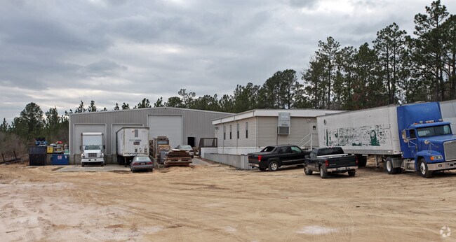
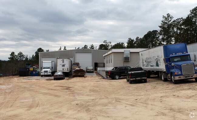
Property Record
1075 Old Wire Rd, Gaston, SC 29053

Property Detail
1075 Old Wire Rd
009000-03-061
TR 3B
Agriculturalland
LEXINGTON
LR
South Carolina
AE The base floodplain where base flood elevations are provided. AE Zones are now used on new format FIRMs instead of A1-A30 Zones.
57.30 AC
2025
Cayce/West Columbia
2024
Columbia
020705
Columbia, SC
2,950 SF
NEARBY LISTINGS FOR SALE OR LEASE
-
-
View all Gaston listings for sale on LoopNet.com
DEMOGRAPHICS near 1075 Old Wire Rd
1 mile
3 mile
5 mile
2025 Total Population
1,748
13,256
26,298
2030 Population
1,876
14,167
27,943
Pop Growth 2025-2030
+ 7.32%
+ 6.87%
+ 6.26%
Average Age
38
39
40
2025 Total Households
665
4,973
10,116
HH Growth 2025-2030
+ 7.52%
+ 7.04%
+ 6.38%
Median Household Inc
$56,666
$59,317
$57,572
Avg Household Size
2.60
2.60
2.50
2025 Avg HH Vehicles
2.00
2.00
2.00
Median Home Value
$191,278
$160,458
$161,782
Median Year Built
1996
1992
1990
Nearby Places
Map Layers
Map Styles
 Street
 Aerial
Layers
 Traffic
 Biking
Places
Listings with unknown addresses are not visible on the map
- Restaurants
- Banks
- Shops
- Fitness
- Groceries
PUBLIC TRANSPORTATION
AIRPORT
Columbia Metro
Drive
Walk
Distance
Columbia Metro
21 min
11.3 mi
Freight Ports
North Charleston Terminal
Drive
Walk
Distance
North Charleston Terminal
110 min
97.9 mi
Nearby Properties
Address
Land Use
TOTAL SIZE
Lot Size
Zoning
Address
Land Use
TOTAL SIZE
Lot Size
Zoning
60.50 AC
Address
Land Use
TOTAL SIZE
Lot Size
Zoning
56.30 AC
Address
Land Use
TOTAL SIZE
Lot Size
Zoning
466,400 SF
52.42 AC
ID
Address
Land Use
TOTAL SIZE
Lot Size
Zoning
186,528 SF
36 AC
Address
Land Use
TOTAL SIZE
Lot Size
Zoning
180,000 SF
27.57 AC
ID
Address
Land Use
TOTAL SIZE
Lot Size
Zoning
181,440 SF
10.69 AC
ID
Address
Land Use
TOTAL SIZE
Lot Size
Zoning
180,000 SF
12.48 AC
ID
Address
Land Use
TOTAL SIZE
Lot Size
Zoning
36.30 AC
Address
Land Use
TOTAL SIZE
Lot Size
Zoning
7.60 AC
Address
Land Use
TOTAL SIZE
Lot Size
Zoning
120,000 SF
18.44 AC
ID
Address
Land Use
TOTAL SIZE
Lot Size
Zoning
Address
Land Use
TOTAL SIZE
Lot Size
Zoning
9,180 SF
10.66 AC
Address
Land Use
TOTAL SIZE
Lot Size
Zoning
58.80 AC
Address
Land Use
TOTAL SIZE
Lot Size
Zoning
85,700 SF
20.45 AC
LR
Address
Land Use
TOTAL SIZE
Lot Size
Zoning
104,190 SF
13.37 AC
Address
Land Use
TOTAL SIZE
Lot Size
Zoning
88,000 SF
16.30 AC
ID
Address
Land Use
TOTAL SIZE
Lot Size
Zoning
61.22 AC
Address
Land Use
TOTAL SIZE
Lot Size
Zoning
23,810 SF
3.95 AC
Address
Land Use
TOTAL SIZE
Lot Size
Zoning
16,200 SF
5.54 AC
ID
Address
Land Use
TOTAL SIZE
Lot Size
Zoning
5,100 SF
4.08 AC
Address
Land Use
TOTAL SIZE
Lot Size
Zoning
31,000 SF
9.73 AC
Address
Land Use
TOTAL SIZE
Lot Size
Zoning
64.10 AC
Address
Land Use
TOTAL SIZE
Lot Size
Zoning
7,150 SF
2.46 AC
Address
Land Use
TOTAL SIZE
Lot Size
Zoning
23,530 SF
4.90 AC
Address
Land Use
TOTAL SIZE
Lot Size
Zoning
1,152 SF
1.96 AC
Address
Land Use
TOTAL SIZE
Lot Size
Zoning
35,787 SF
4.08 AC
Address
Land Use
TOTAL SIZE
Lot Size
Zoning
15 AC
ID
Address
Land Use
TOTAL SIZE
Lot Size
Zoning
171.90 AC
Address
Land Use
TOTAL SIZE
Lot Size
Zoning
41,608 SF
20.47 AC
C
Address
Land Use
TOTAL SIZE
Lot Size
Zoning
5,880 SF
1.02 AC
The World's #1 Commercial Real Estate Marketplace
Connect with us
© 2026 CoStar Group
The information above has been obtained from sources believed reliable. While we do not doubt its accuracy we have not verified it and make no guarantee, warranty or representation about it. It is your responsibility to independently confirm its accuracy and completeness. Any projections, opinions, assumptions, or estimates used are for example only and do not represent the current or future performance of the property. The value of this transaction to you depends on tax and other factors which should be evaluated by your tax, financial, and legal advisors. You and your advisors should conduct a careful, independent investigation of the property to determine to your satisfaction the suitability of the property for your needs.