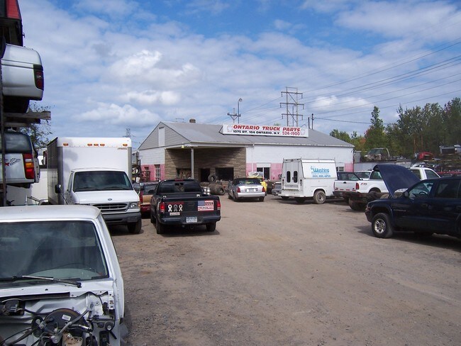
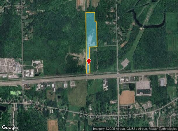
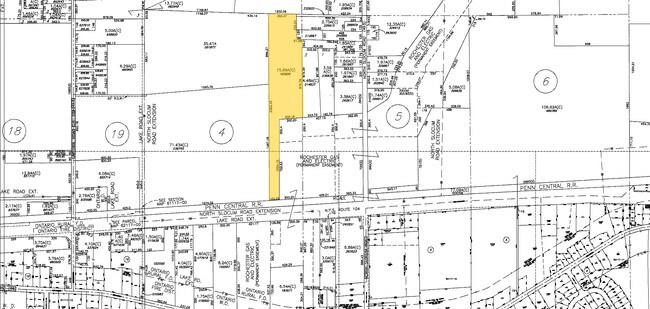
Property Record
1075 State Route 104, Ontario, NY 14519
NEARBY LISTINGS FOR SALE OR LEASE
-
-
View all Ontario listings for sale on LoopNet.com
Property Detail
1075 State Route 104
Rochester, NY
30117-00-153855
543400-062-117-0000-182-828-0000
Wayne
Storageyardjunkautowreckingsalvage
New York
2025
182.828
2024
15.69 AC
020103
Wayne County
2,226 SF
Rochester
DEMOGRAPHICS near 1075 State Route 104
1 Mile
3 Mile
5 Mile
2024 Total Population
1,655
8,889
22,299
2029 Population
1,638
8,809
22,012
Pop Growth 2024-2029
(1.03%)
(0.90%)
(1.29%)
Average Age
44
43
42
2024 Total Households
689
3,607
8,905
HH Growth 2024-2029
(1.16%)
(0.94%)
(1.33%)
Median Household Inc
$81,391
$80,991
$85,194
Avg Household Size
2.40
2.40
2.50
2024 Avg HH Vehicles
2.00
2.00
2.00
Median Home Value
$195,126
$190,765
$215,322
Median Year Built
1991
1978
1979
Nearby Places
- Restaurants
- Banks
- Shops
- Fitness
- Groceries
PUBLIC TRANSPORTATION
AIRPORT
Frederick Douglass/Greater Rochester International
DRIVE
WALK
Distance
Frederick Douglass/Greater Rochester International
32 min
21.9 mi
Freight Ports
Albany, NY Port
DRIVE
WALK
Distance
Albany, NY Port
258 min
210.2 mi
Nearby Properties
Address
Land Use
TOTAL SIZE
Lot Size
Zoning
Address
Land Use
TOTAL SIZE
Lot Size
Zoning
150,591 SF
18.18 AC
I
Address
Land Use
TOTAL SIZE
Lot Size
Zoning
150,432 SF
27.02 AC
SR
Address
Land Use
TOTAL SIZE
Lot Size
Zoning
0.01 AC
R
Address
Land Use
TOTAL SIZE
Lot Size
Zoning
73,600 SF
50.33 AC
SR
Address
Land Use
TOTAL SIZE
Lot Size
Zoning
0.01 AC
Address
Land Use
TOTAL SIZE
Lot Size
Zoning
110.41 AC
Address
Land Use
TOTAL SIZE
Lot Size
Zoning
30,064 SF
119.63 AC
I
Address
Land Use
TOTAL SIZE
Lot Size
Zoning
71,459 SF
10.19 AC
B
Address
Land Use
TOTAL SIZE
Lot Size
Zoning
74,400 SF
6.65 AC
I
Address
Land Use
TOTAL SIZE
Lot Size
Zoning
55,100 SF
6.98 AC
B
Address
Land Use
TOTAL SIZE
Lot Size
Zoning
9.18 AC
SR
Address
Land Use
TOTAL SIZE
Lot Size
Zoning
10.09 AC
AE/I
Address
Land Use
TOTAL SIZE
Lot Size
Zoning
27,332 SF
2.85 AC
B
Address
Land Use
TOTAL SIZE
Lot Size
Zoning
34,000 SF
23.51 AC
SR
Address
Land Use
TOTAL SIZE
Lot Size
Zoning
0.90 AC
I
Address
Land Use
TOTAL SIZE
Lot Size
Zoning
80,100 SF
5 AC
I
Address
Land Use
TOTAL SIZE
Lot Size
Zoning
8.19 AC
PD
Address
Land Use
TOTAL SIZE
Lot Size
Zoning
54,600 SF
5.59 AC
I
Address
Land Use
TOTAL SIZE
Lot Size
Zoning
86,188 SF
14.89 AC
B
Address
Land Use
TOTAL SIZE
Lot Size
Zoning
3,714 SF
39.97 AC
CON
Address
Land Use
TOTAL SIZE
Lot Size
Zoning
45,306 SF
4.30 AC
I
Address
Land Use
TOTAL SIZE
Lot Size
Zoning
45,839 SF
5.71 AC
UR
Address
Land Use
TOTAL SIZE
Lot Size
Zoning
14,074 SF
1.70 AC
B
Address
Land Use
TOTAL SIZE
Lot Size
Zoning
21,688 SF
3.80 AC
06 - INDUS
Address
Land Use
TOTAL SIZE
Lot Size
Zoning
12,284 SF
3.67 AC
B
Address
Land Use
TOTAL SIZE
Lot Size
Zoning
7,820 SF
9.11 AC
06 - INDUS
Address
Land Use
TOTAL SIZE
Lot Size
Zoning
24,246 SF
12.83 AC
I
Address
Land Use
TOTAL SIZE
Lot Size
Zoning
39,493 SF
3.79 AC
06 - INDUS
Address
Land Use
TOTAL SIZE
Lot Size
Zoning
16 AC
SR
Address
Land Use
TOTAL SIZE
Lot Size
Zoning
0.52 AC
BT
The World's #1 Commercial Real Estate Marketplace
Connect with us
© 2025 CoStar Group
The information above has been obtained from sources believed reliable. While we do not doubt its accuracy we have not verified it and make no guarantee, warranty or representation about it. It is your responsibility to independently confirm its accuracy and completeness. Any projections, opinions, assumptions, or estimates used are for example only and do not represent the current or future performance of the property. The value of this transaction to you depends on tax and other factors which should be evaluated by your tax, financial, and legal advisors. You and your advisors should conduct a careful, independent investigation of the property to determine to your satisfaction the suitability of the property for your needs.