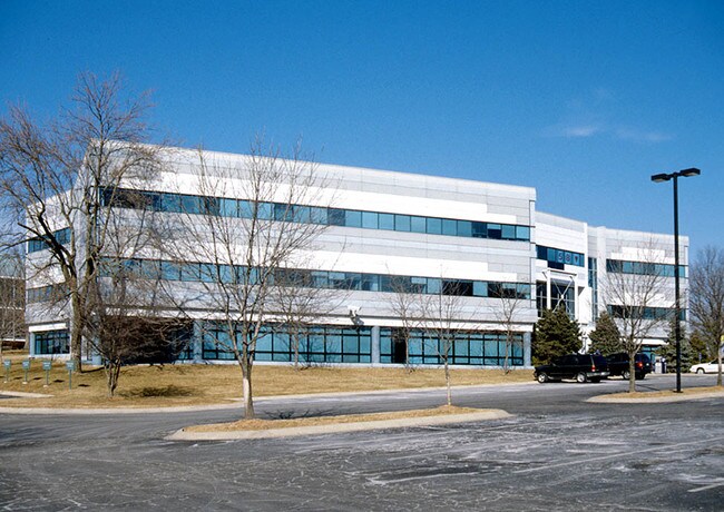
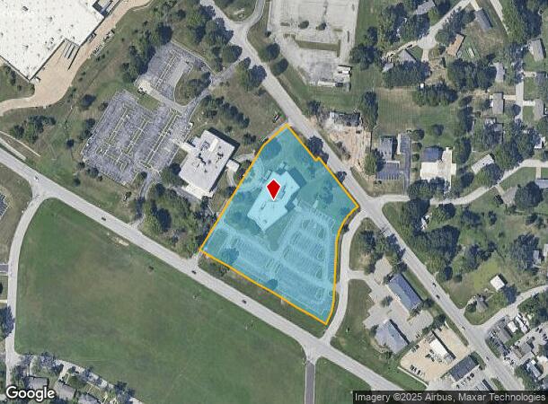
Property Record
10750 E State Route 350, Raytown, MO 64138
NEARBY LISTINGS FOR SALE OR LEASE
Property Detail
10750 E State Route 350
45-720-02-06-02-2-00-000
RNG-32 TWP-48 SEC-16 BEG AT SE COR NW 1/4 TH N 454.19 TH N 61 DEG W 146.19 TO TRU POB TH N 61 DEG W 494.71 TH N 28 DE G E 410.97 TH N 48 DEG E 94.98 TH S 40 DEG E 157.20 TH N
Officebuilding
Jackson
X
Missouri
29095C0402G
3.25 AC
0
East Jackson County
2025
Kansas City
012702
Kansas City, MO-KS
35,646 SF
DEMOGRAPHICS near 10750 E State Route 350
1 Mile
3 Mile
5 Mile
2024 Total Population
8,787
46,153
111,697
2029 Population
8,668
45,677
111,371
Pop Growth 2024-2029
(1.35%)
(1.03%)
(0.29%)
Average Age
42
41
40
2024 Total Households
3,599
18,891
45,615
HH Growth 2024-2029
(1.50%)
(1.17%)
(0.41%)
Median Household Inc
$67,806
$61,316
$60,955
Avg Household Size
2.40
2.40
2.30
2024 Avg HH Vehicles
2.00
2.00
2.00
Median Home Value
$157,033
$158,037
$168,775
Median Year Built
1965
1966
1968
Nearby Places
Map Layers
Map Styles
 Street
 Aerial
- Restaurants
- Banks
- Shops
- Fitness
- Groceries
PUBLIC TRANSPORTATION
COMMUTER RAIL
DRIVE
WALK
Distance
13 min
7.4 mi
AIRPORT
Kansas City International
DRIVE
WALK
Distance
Kansas City International
45 min
35.1 mi
Nearby Properties
Address
Land Use
TOTAL SIZE
Lot Size
Zoning
Address
Land Use
TOTAL SIZE
Lot Size
Zoning
175,318 SF
26.37 AC
Address
Land Use
TOTAL SIZE
Lot Size
Zoning
69,771 SF
83.01 AC
Address
Land Use
TOTAL SIZE
Lot Size
Zoning
168,184 SF
18.63 AC
Address
Land Use
TOTAL SIZE
Lot Size
Zoning
389,227 SF
33.30 AC
Address
Land Use
TOTAL SIZE
Lot Size
Zoning
173,321 SF
40 AC
Address
Land Use
TOTAL SIZE
Lot Size
Zoning
42,417 SF
21.81 AC
Address
Land Use
TOTAL SIZE
Lot Size
Zoning
57,442 SF
59.91 AC
Address
Land Use
TOTAL SIZE
Lot Size
Zoning
33,541 SF
21.83 AC
Address
Land Use
TOTAL SIZE
Lot Size
Zoning
176,132 SF
0.27 AC
Address
Land Use
TOTAL SIZE
Lot Size
Zoning
73,434 SF
10.35 AC
Address
Land Use
TOTAL SIZE
Lot Size
Zoning
47,537 SF
15.70 AC
Address
Land Use
TOTAL SIZE
Lot Size
Zoning
43,200 SF
4.37 AC
Address
Land Use
TOTAL SIZE
Lot Size
Zoning
67,570 SF
5.71 AC
Address
Land Use
TOTAL SIZE
Lot Size
Zoning
47,099 SF
3.55 AC
Address
Land Use
TOTAL SIZE
Lot Size
Zoning
22,913 SF
151.50 AC
Address
Land Use
TOTAL SIZE
Lot Size
Zoning
49,839 SF
2.97 AC
Address
Land Use
TOTAL SIZE
Lot Size
Zoning
37,401 SF
18.22 AC
Address
Land Use
TOTAL SIZE
Lot Size
Zoning
143,803 SF
9.17 AC
Address
Land Use
TOTAL SIZE
Lot Size
Zoning
36,220 SF
6.61 AC
Address
Land Use
TOTAL SIZE
Lot Size
Zoning
60,372 SF
12.37 AC
Address
Land Use
TOTAL SIZE
Lot Size
Zoning
9,627 SF
10.66 AC
Address
Land Use
TOTAL SIZE
Lot Size
Zoning
76,844 SF
8.26 AC
Address
Land Use
TOTAL SIZE
Lot Size
Zoning
129,087 SF
19.85 AC
Address
Land Use
TOTAL SIZE
Lot Size
Zoning
86,614 SF
9.22 AC
Address
Land Use
TOTAL SIZE
Lot Size
Zoning
91,756 SF
8.48 AC
Address
Land Use
TOTAL SIZE
Lot Size
Zoning
34,344 SF
3.30 AC
Address
Land Use
TOTAL SIZE
Lot Size
Zoning
52,865 SF
5.98 AC
Address
Land Use
TOTAL SIZE
Lot Size
Zoning
86,522 SF
2.18 AC
Address
Land Use
TOTAL SIZE
Lot Size
Zoning
47,958 SF
2.61 AC
The World's #1 Commercial Real Estate Marketplace
Connect with us
© 2025 CoStar Group
The information above has been obtained from sources believed reliable. While we do not doubt its accuracy we have not verified it and make no guarantee, warranty or representation about it. It is your responsibility to independently confirm its accuracy and completeness. Any projections, opinions, assumptions, or estimates used are for example only and do not represent the current or future performance of the property. The value of this transaction to you depends on tax and other factors which should be evaluated by your tax, financial, and legal advisors. You and your advisors should conduct a careful, independent investigation of the property to determine to your satisfaction the suitability of the property for your needs.