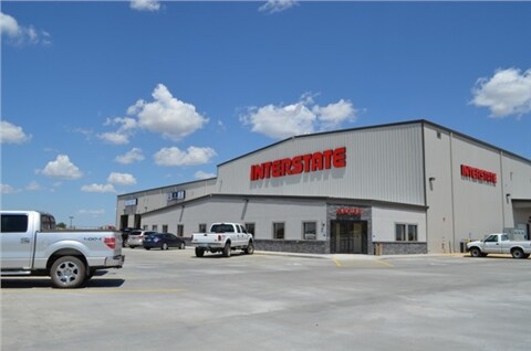
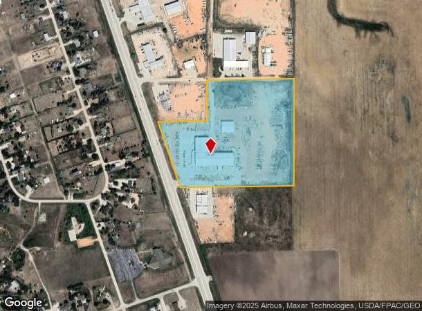
Property Record
10750 State Highway 59 S, Gillette, WY 82718
NEARBY LISTINGS FOR SALE OR LEASE
-
-
View all Gillette listings for sale on LoopNet.com
Property Detail
10750 State Highway 59 S
Gillette, WY
Antelope Valley Business Park
R0057965
ANTELOPE VALLEY BUSINESS PARK PH III, LOT 13
Officebuilding
Campbell
X
Wyoming
56005C1677D
13
2024
17.94 AC
2025
Wyoming Area
000200
Other Market Areas
58,183 SF
DEMOGRAPHICS near 10750 State Highway 59 S
1 Mile
3 Mile
5 Mile
2024 Total Population
1,535
5,271
23,070
2029 Population
1,542
5,332
23,467
Pop Growth 2024-2029
+ 0.46%
+ 1.16%
+ 1.72%
Average Age
37
34
35
2024 Total Households
580
1,905
8,729
HH Growth 2024-2029
+ 0.34%
+ 1.10%
+ 1.71%
Median Household Inc
$115,490
$99,412
$90,227
Avg Household Size
2.60
2.70
2.60
2024 Avg HH Vehicles
2.00
3.00
2.00
Median Home Value
$335,467
$277,192
$255,495
Median Year Built
1984
1991
1988
Nearby Places
Map Layers
Map Styles
 Street
 Aerial
- Restaurants
- Banks
- Shops
- Fitness
- Groceries
Nearby Properties
Address
Land Use
TOTAL SIZE
Lot Size
Zoning
Address
Land Use
TOTAL SIZE
Lot Size
Zoning
154,664 SF
33.94 AC
Address
Land Use
TOTAL SIZE
Lot Size
Zoning
56,378 SF
4.37 AC
Address
Land Use
TOTAL SIZE
Lot Size
Zoning
72,272 SF
5.90 AC
Address
Land Use
TOTAL SIZE
Lot Size
Zoning
40,200 SF
8.57 AC
Address
Land Use
TOTAL SIZE
Lot Size
Zoning
51,274 SF
4.52 AC
Address
Land Use
TOTAL SIZE
Lot Size
Zoning
26,478 SF
3.07 AC
Address
Land Use
TOTAL SIZE
Lot Size
Zoning
19,743 SF
2.55 AC
Address
Land Use
TOTAL SIZE
Lot Size
Zoning
32,740 SF
18.23 AC
Address
Land Use
TOTAL SIZE
Lot Size
Zoning
40,800 SF
3.53 AC
Address
Land Use
TOTAL SIZE
Lot Size
Zoning
23,016 SF
3.90 AC
Address
Land Use
TOTAL SIZE
Lot Size
Zoning
10,959 SF
1.17 AC
Address
Land Use
TOTAL SIZE
Lot Size
Zoning
7,244 SF
3.88 AC
Address
Land Use
TOTAL SIZE
Lot Size
Zoning
23,300 SF
5.25 AC
Address
Land Use
TOTAL SIZE
Lot Size
Zoning
35,344 SF
5.44 AC
Address
Land Use
TOTAL SIZE
Lot Size
Zoning
15,000 SF
7.39 AC
Address
Land Use
TOTAL SIZE
Lot Size
Zoning
22,820 SF
7.60 AC
Address
Land Use
TOTAL SIZE
Lot Size
Zoning
9,230 SF
3.38 AC
Address
Land Use
TOTAL SIZE
Lot Size
Zoning
12,512 SF
4.95 AC
Address
Land Use
TOTAL SIZE
Lot Size
Zoning
10,703 SF
1.50 AC
Address
Land Use
TOTAL SIZE
Lot Size
Zoning
20,344 SF
8.58 AC
Address
Land Use
TOTAL SIZE
Lot Size
Zoning
12,234 SF
4.13 AC
Address
Land Use
TOTAL SIZE
Lot Size
Zoning
7,140 SF
3.53 AC
Address
Land Use
TOTAL SIZE
Lot Size
Zoning
15,392 SF
2.53 AC
Address
Land Use
TOTAL SIZE
Lot Size
Zoning
16,950 SF
5.38 AC
Address
Land Use
TOTAL SIZE
Lot Size
Zoning
8,360 SF
6.04 AC
Address
Land Use
TOTAL SIZE
Lot Size
Zoning
11,498 SF
35.01 AC
Address
Land Use
TOTAL SIZE
Lot Size
Zoning
16,200 SF
2.85 AC
Address
Land Use
TOTAL SIZE
Lot Size
Zoning
4,498 SF
1.63 AC
Address
Land Use
TOTAL SIZE
Lot Size
Zoning
8,002 SF
3,332.59 AC
The World's #1 Commercial Real Estate Marketplace
Connect with us
© 2026 CoStar Group
The information above has been obtained from sources believed reliable. While we do not doubt its accuracy we have not verified it and make no guarantee, warranty or representation about it. It is your responsibility to independently confirm its accuracy and completeness. Any projections, opinions, assumptions, or estimates used are for example only and do not represent the current or future performance of the property. The value of this transaction to you depends on tax and other factors which should be evaluated by your tax, financial, and legal advisors. You and your advisors should conduct a careful, independent investigation of the property to determine to your satisfaction the suitability of the property for your needs.