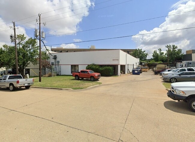
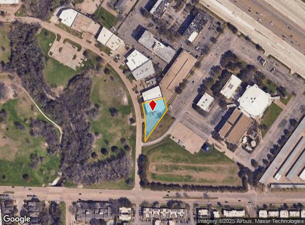
Property Record
10765 Mapleridge Dr, Dallas, TX 75238
NEARBY LISTINGS FOR SALE OR LEASE
Property Detail
10765 Mapleridge Dr
Dallas-Fort Worth-Arlington, TX
Shelton/Dallas Northeast
0080510B000080000
SHELTON/DALLAS NORTHEAST BLK B/8051 LOT 8 ACS 0.5720 VOL92022/3526 EF010192 CO-DALLAS 8051 00B 00800 3008051 00B
Officebuilding
Dallas
X
Texas
48113C0215K
8
2024
0.57 AC
2025
Northeast Dallas
013011
Dallas/Ft Worth
9,547 SF
DEMOGRAPHICS near 10765 Mapleridge Dr
1 Mile
3 Mile
5 Mile
2024 Total Population
11,943
136,618
414,938
2029 Population
11,829
135,177
411,594
Pop Growth 2024-2029
(0.95%)
(1.05%)
(0.81%)
Average Age
36
36
37
2024 Total Households
4,694
52,232
162,108
HH Growth 2024-2029
(1.07%)
(1.13%)
(0.83%)
Median Household Inc
$62,903
$54,949
$58,135
Avg Household Size
2.50
2.50
2.50
2024 Avg HH Vehicles
2.00
2.00
2.00
Median Home Value
$374,668
$333,867
$273,276
Median Year Built
1972
1974
1975
Nearby Places
Map Layers
Map Styles
 Street
 Aerial
- Restaurants
- Banks
- Shops
- Fitness
- Groceries
PUBLIC TRANSPORTATION
AIRPORT
Dallas Love Field
DRIVE
WALK
Distance
Dallas Love Field
25 min
12.0 mi
Dallas-Fort Worth International
DRIVE
WALK
Distance
Dallas-Fort Worth International
33 min
26.6 mi
Nearby Properties
Address
Land Use
TOTAL SIZE
Lot Size
Zoning
Address
Land Use
TOTAL SIZE
Lot Size
Zoning
306,323 SF
10.99 AC
Z164
Address
Land Use
TOTAL SIZE
Lot Size
Zoning
403,415 SF
3.43 AC
Z163
Address
Land Use
TOTAL SIZE
Lot Size
Zoning
691,816 SF
19.50 AC
Z239
Address
Land Use
TOTAL SIZE
Lot Size
Zoning
319,969 SF
16.54 AC
Z163
Address
Land Use
TOTAL SIZE
Lot Size
Zoning
310,119 SF
9.65 AC
Z150
Address
Land Use
TOTAL SIZE
Lot Size
Zoning
391,774 SF
3.97 AC
Z239
Address
Land Use
TOTAL SIZE
Lot Size
Zoning
445,781 SF
4.57 AC
Z239
Address
Land Use
TOTAL SIZE
Lot Size
Zoning
144,728 SF
46.87 AC
Z239
Address
Land Use
TOTAL SIZE
Lot Size
Zoning
517,500 SF
29.97 AC
Z116
Address
Land Use
TOTAL SIZE
Lot Size
Zoning
922,851 SF
52.30 AC
Z144
Address
Land Use
TOTAL SIZE
Lot Size
Zoning
431,982 SF
19.32 AC
Z164
Address
Land Use
TOTAL SIZE
Lot Size
Zoning
480,000 SF
25.27 AC
Z239
Address
Land Use
TOTAL SIZE
Lot Size
Zoning
472,244 SF
25.25 AC
Z144
Address
Land Use
TOTAL SIZE
Lot Size
Zoning
292,827 SF
13.81 AC
Z163
Address
Land Use
TOTAL SIZE
Lot Size
Zoning
531,950 SF
24.62 AC
Z239
Address
Land Use
TOTAL SIZE
Lot Size
Zoning
347,718 SF
18.61 AC
Z163
Address
Land Use
TOTAL SIZE
Lot Size
Zoning
922,851 SF
52.28 AC
Z144
Address
Land Use
TOTAL SIZE
Lot Size
Zoning
121,440 SF
17.02 AC
Z298
Address
Land Use
TOTAL SIZE
Lot Size
Zoning
227,584 SF
12.03 AC
Z165
Address
Land Use
TOTAL SIZE
Lot Size
Zoning
333,298 SF
10.91 AC
Z149
Address
Land Use
TOTAL SIZE
Lot Size
Zoning
195,495 SF
9.61 AC
Z298
Address
Land Use
TOTAL SIZE
Lot Size
Zoning
265,986 SF
13.75 AC
Z163
Address
Land Use
TOTAL SIZE
Lot Size
Zoning
468,220 SF
20.60 AC
Z144
Address
Land Use
TOTAL SIZE
Lot Size
Zoning
270,114 SF
8.50 AC
Z150
Address
Land Use
TOTAL SIZE
Lot Size
Zoning
203,027 SF
17.69 AC
Z294
Address
Land Use
TOTAL SIZE
Lot Size
Zoning
278,856 SF
9.57 AC
Z150
Address
Land Use
TOTAL SIZE
Lot Size
Zoning
220,989 SF
12.94 AC
Z163
Address
Land Use
TOTAL SIZE
Lot Size
Zoning
244,032 SF
11.06 AC
Z163
Address
Land Use
TOTAL SIZE
Lot Size
Zoning
297,172 SF
12.28 AC
Z59
Address
Land Use
TOTAL SIZE
Lot Size
Zoning
321,118 SF
2.82 AC
Z163
The World's #1 Commercial Real Estate Marketplace
Connect with us
© 2025 CoStar Group
The information above has been obtained from sources believed reliable. While we do not doubt its accuracy we have not verified it and make no guarantee, warranty or representation about it. It is your responsibility to independently confirm its accuracy and completeness. Any projections, opinions, assumptions, or estimates used are for example only and do not represent the current or future performance of the property. The value of this transaction to you depends on tax and other factors which should be evaluated by your tax, financial, and legal advisors. You and your advisors should conduct a careful, independent investigation of the property to determine to your satisfaction the suitability of the property for your needs.