Property Record
1077 Highway A1a, Satellite Beach, FL 32937

NEARBY LISTINGS FOR SALE OR LEASE
-
-
View all Satellite Beach listings for lease on LoopNet.com
Property Detail
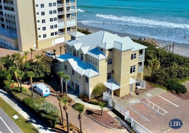
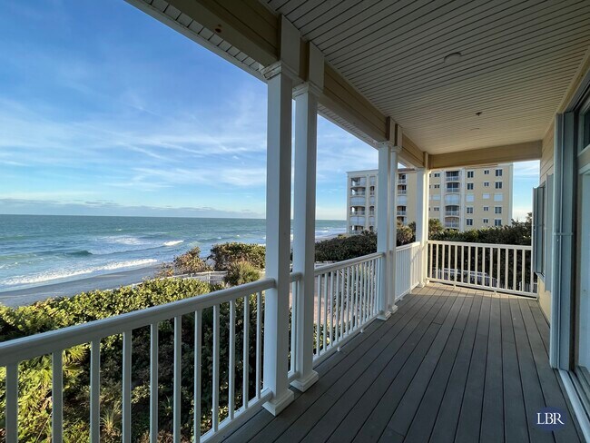
1077 Highway A1a
Palm Bay-Melbourne-Titusville, FL
Bella Vista Townhomes
26-37-35-00-00012.0-0000.00
S 200 FT OF N 1000 FT OF LOT 1 E OF HWY A1A AS DES IN ORB 617 PG 253 EXC ORB 3915 PG 513
Officebuilding
Brevard
VE
Florida
12009C0537H
1
2024
0.57 AC
2025
Brevard County
066700
Orlando
8,306 SF
DEMOGRAPHICS near 1077 Highway A1a
1 Mile
3 Mile
5 Mile
2024 Total Population
6,819
27,679
60,642
2029 Population
7,461
30,268
66,056
Pop Growth 2024-2029
+ 9.41%
+ 9.35%
+ 8.93%
Average Age
43
46
45
2024 Total Households
2,759
11,848
26,783
HH Growth 2024-2029
+ 9.10%
+ 9.16%
+ 8.71%
Median Household Inc
$92,734
$87,059
$73,618
Avg Household Size
2.50
2.30
2.20
2024 Avg HH Vehicles
2.00
2.00
2.00
Median Home Value
$361,818
$368,198
$322,882
Median Year Built
1973
1975
1980
Nearby Places
Map Layers
Map Styles
 Street
 Aerial
- Restaurants
- Banks
- Shops
- Fitness
- Groceries
PUBLIC TRANSPORTATION
AIRPORT
Melbourne Orlando International
DRIVE
WALK
Distance
Melbourne Orlando International
25 min
11.0 mi
Freight Ports
Port Canaveral
DRIVE
WALK
Distance
Port Canaveral
31 min
15.9 mi
SALE & LEASE HISTORY
LISTING DATE
SALE/LEASE

Oct 24, 2019
For Sale
Oct 12, 2020
For Lease
Feb 07, 2024
For Lease
Nearby Properties
Address
Land Use
TOTAL SIZE
Lot Size
Zoning
Address
Land Use
TOTAL SIZE
Lot Size
Zoning
1,339.40 AC
Address
Land Use
TOTAL SIZE
Lot Size
Zoning
511,907 SF
75.60 AC
ITU
Address
Land Use
TOTAL SIZE
Lot Size
Zoning
252,942 SF
29.76 AC
R3
Address
Land Use
TOTAL SIZE
Lot Size
Zoning
162,759 SF
8.49 AC
RU230
Address
Land Use
TOTAL SIZE
Lot Size
Zoning
90.10 AC
Address
Land Use
TOTAL SIZE
Lot Size
Zoning
94,097 SF
3.21 AC
R2
Address
Land Use
TOTAL SIZE
Lot Size
Zoning
106,333 SF
2.52 AC
B1
Address
Land Use
TOTAL SIZE
Lot Size
Zoning
7.02 AC
ITU
Address
Land Use
TOTAL SIZE
Lot Size
Zoning
75,076 SF
3.67 AC
RU215
Address
Land Use
TOTAL SIZE
Lot Size
Zoning
152,762 SF
13.70 AC
C
Address
Land Use
TOTAL SIZE
Lot Size
Zoning
2,792 SF
6.36 AC
ITU
Address
Land Use
TOTAL SIZE
Lot Size
Zoning
144,052 SF
13.28 AC
B1
Address
Land Use
TOTAL SIZE
Lot Size
Zoning
55,552 SF
1.50 AC
Address
Land Use
TOTAL SIZE
Lot Size
Zoning
72,781 SF
9.54 AC
IN(L)
Address
Land Use
TOTAL SIZE
Lot Size
Zoning
108,296 SF
3.52 AC
Address
Land Use
TOTAL SIZE
Lot Size
Zoning
33,556 SF
1.04 AC
R3
Address
Land Use
TOTAL SIZE
Lot Size
Zoning
66,611 SF
14 AC
P2
Address
Land Use
TOTAL SIZE
Lot Size
Zoning
27,825 SF
5.70 AC
B1
Address
Land Use
TOTAL SIZE
Lot Size
Zoning
52,726 SF
12.51 AC
RU111
Address
Land Use
TOTAL SIZE
Lot Size
Zoning
34,467 SF
5.59 AC
R1AAA
Address
Land Use
TOTAL SIZE
Lot Size
Zoning
44,045 SF
3.50 AC
TU-1
Address
Land Use
TOTAL SIZE
Lot Size
Zoning
31,356 SF
1.17 AC
R3
Address
Land Use
TOTAL SIZE
Lot Size
Zoning
37,948 SF
1.38 AC
RM2
Address
Land Use
TOTAL SIZE
Lot Size
Zoning
26.07 AC
Address
Land Use
TOTAL SIZE
Lot Size
Zoning
Address
Land Use
TOTAL SIZE
Lot Size
Zoning
8.30 AC
ITU
Address
Land Use
TOTAL SIZE
Lot Size
Zoning
52,685 SF
12 AC
ITU
Address
Land Use
TOTAL SIZE
Lot Size
Zoning
16,537 SF
3.13 AC
B1
Address
Land Use
TOTAL SIZE
Lot Size
Zoning
65,385 SF
4.74 AC
C
Address
Land Use
TOTAL SIZE
Lot Size
Zoning
12,455 SF
4.87 AC
RU-1-13
The World's #1 Commercial Real Estate Marketplace
Connect with us
© 2025 CoStar Group
The information above has been obtained from sources believed reliable. While we do not doubt its accuracy we have not verified it and make no guarantee, warranty or representation about it. It is your responsibility to independently confirm its accuracy and completeness. Any projections, opinions, assumptions, or estimates used are for example only and do not represent the current or future performance of the property. The value of this transaction to you depends on tax and other factors which should be evaluated by your tax, financial, and legal advisors. You and your advisors should conduct a careful, independent investigation of the property to determine to your satisfaction the suitability of the property for your needs.