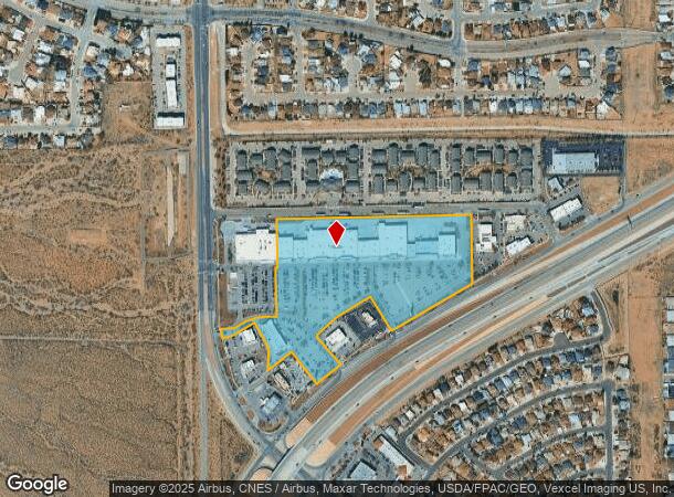
Property Record
10771 Gateway Blvd S, El Paso, TX 79934
NEARBY LISTINGS FOR SALE OR LEASE
Property Detail
10771 Gateway Blvd S
El Paso
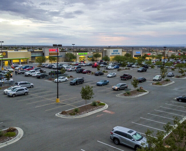
North Hills Crossing
El Paso, TX
BLK 1 NORTH HILLS CROSSING 3 (EXC SWLY PTS) (18.1820 AC)
N427-999-0010-0300
El Paso
Commercialnec
Texas
2024
3
2025
18.18 AC
010210
Northeast
158,370 SF
DEMOGRAPHICS near 10771 Gateway Blvd S
1 Mile
3 Mile
5 Mile
2024 Total Population
12,961
56,770
102,318
2029 Population
12,952
57,118
103,187
Pop Growth 2024-2029
(0.07%)
+ 0.61%
+ 0.85%
Average Age
37
36
36
2024 Total Households
4,587
20,209
36,875
HH Growth 2024-2029
(0.04%)
+ 0.66%
+ 0.94%
Median Household Inc
$81,338
$59,307
$50,834
Avg Household Size
2.80
2.70
2.70
2024 Avg HH Vehicles
2.00
2.00
2.00
Median Home Value
$168,367
$144,519
$138,979
Median Year Built
1997
1984
1981
Nearby Places
Map Layers
Map Styles
 Street
 Aerial
- Restaurants
- Banks
- Shops
- Fitness
- Groceries
PUBLIC TRANSPORTATION
AIRPORT
El Paso International
DRIVE
WALK
Distance
El Paso International
17 min
14.0 mi
SALE & LEASE HISTORY
LISTING DATE
SALE/LEASE

May 04, 2017
For Lease
Nearby Properties
Address
Land Use
TOTAL SIZE
Lot Size
Zoning
Address
Land Use
TOTAL SIZE
Lot Size
Zoning
427,550 SF
40 AC
R4
Address
Land Use
TOTAL SIZE
Lot Size
Zoning
311,618 SF
17.74 AC
C3
Address
Land Use
TOTAL SIZE
Lot Size
Zoning
263,488 SF
13.88 AC
R3
Address
Land Use
TOTAL SIZE
Lot Size
Zoning
261,148 SF
21.61 AC
PR2
Address
Land Use
TOTAL SIZE
Lot Size
Zoning
117,210 SF
8.55 AC
R4
Address
Land Use
TOTAL SIZE
Lot Size
Zoning
73,904 SF
42.88 AC
R4
Address
Land Use
TOTAL SIZE
Lot Size
Zoning
136,000 SF
84.83 AC
R4
Address
Land Use
TOTAL SIZE
Lot Size
Zoning
240,114 SF
26.84 AC
C1
Address
Land Use
TOTAL SIZE
Lot Size
Zoning
231,035 SF
15.85 AC
R3
Address
Land Use
TOTAL SIZE
Lot Size
Zoning
123,824 SF
3.85 AC
A3
Address
Land Use
TOTAL SIZE
Lot Size
Zoning
76,082 SF
13.59 AC
Address
Land Use
TOTAL SIZE
Lot Size
Zoning
28,289 SF
3.31 AC
C1
Address
Land Use
TOTAL SIZE
Lot Size
Zoning
136,880 SF
19.21 AC
C3
Address
Land Use
TOTAL SIZE
Lot Size
Zoning
26,276 SF
1.53 AC
Address
Land Use
TOTAL SIZE
Lot Size
Zoning
46,318 SF
4.92 AC
C3
Address
Land Use
TOTAL SIZE
Lot Size
Zoning
78,875 SF
6.41 AC
C3
Address
Land Use
TOTAL SIZE
Lot Size
Zoning
133,538 SF
10.04 AC
C1
Address
Land Use
TOTAL SIZE
Lot Size
Zoning
75,857 SF
C1
Address
Land Use
TOTAL SIZE
Lot Size
Zoning
91,288 SF
14 AC
C1
Address
Land Use
TOTAL SIZE
Lot Size
Zoning
27,963 SF
2 AC
C1
Address
Land Use
TOTAL SIZE
Lot Size
Zoning
39,270 SF
2.52 AC
C3
Address
Land Use
TOTAL SIZE
Lot Size
Zoning
41,700 SF
4.83 AC
C3
Address
Land Use
TOTAL SIZE
Lot Size
Zoning
174,134 SF
10.25 AC
A2S
Address
Land Use
TOTAL SIZE
Lot Size
Zoning
127,112 SF
7.24 AC
A2
Address
Land Use
TOTAL SIZE
Lot Size
Zoning
40,726 SF
4 AC
R3A
Address
Land Use
TOTAL SIZE
Lot Size
Zoning
69,126 SF
12.65 AC
C1
Address
Land Use
TOTAL SIZE
Lot Size
Zoning
49,464 SF
1.41 AC
C1
Address
Land Use
TOTAL SIZE
Lot Size
Zoning
57,232 SF
11.16 AC
R4
Address
Land Use
TOTAL SIZE
Lot Size
Zoning
107,023 SF
5.47 AC
A2S
The World's #1 Commercial Real Estate Marketplace
Connect with us
© 2025 CoStar Group
The information above has been obtained from sources believed reliable. While we do not doubt its accuracy we have not verified it and make no guarantee, warranty or representation about it. It is your responsibility to independently confirm its accuracy and completeness. Any projections, opinions, assumptions, or estimates used are for example only and do not represent the current or future performance of the property. The value of this transaction to you depends on tax and other factors which should be evaluated by your tax, financial, and legal advisors. You and your advisors should conduct a careful, independent investigation of the property to determine to your satisfaction the suitability of the property for your needs.