Property Record
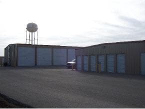
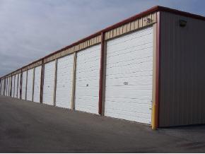
10772 State Highway 76, Forsyth, MO 65653

Property Detail
10772 State Highway 76
09-2.0-03-000-000-033.004
PT S2 SW4;
Commercialnec
TANEY
B and X Area of moderate flood hazard, usually the area between the limits of the 100-year and 500-year floods.
Missouri
2024
3.72 AC
2025
Other Market Areas
480403
Branson, MO
46,940 SF
NEARBY LISTINGS FOR SALE OR LEASE
-
-
View all Forsyth listings for sale on LoopNet.com
DEMOGRAPHICS near 10772 State Highway 76
1 mile
3 mile
5 mile
2025 Total Population
724
5,415
11,690
2030 Population
700
5,217
11,425
Pop Growth 2025-2030
(3.31%)
(3.66%)
(2.27%)
Average Age
43
45
43
2025 Total Households
293
2,240
4,674
HH Growth 2025-2030
(3.75%)
(4.15%)
(2.63%)
Median Household Inc
$47,840
$47,925
$53,424
Avg Household Size
2.50
2.30
2.40
2025 Avg HH Vehicles
2.00
2.00
2.00
Median Home Value
$192,777
$186,363
$189,968
Median Year Built
1977
1984
1989
Nearby Places
Map Layers
Map Styles
 Street
 Aerial
Layers
 Traffic
 Biking
Places
Listings with unknown addresses are not visible on the map
- Restaurants
- Banks
- Shops
- Fitness
- Groceries
Nearby Properties
Address
Land Use
TOTAL SIZE
Lot Size
Zoning
Address
Land Use
TOTAL SIZE
Lot Size
Zoning
20,616 SF
0.90 AC
Address
Land Use
TOTAL SIZE
Lot Size
Zoning
32,706 SF
4.63 AC
Address
Land Use
TOTAL SIZE
Lot Size
Zoning
18,960 SF
2.70 AC
Address
Land Use
TOTAL SIZE
Lot Size
Zoning
45,500 SF
9.33 AC
Address
Land Use
TOTAL SIZE
Lot Size
Zoning
4,233 SF
0.29 AC
Address
Land Use
TOTAL SIZE
Lot Size
Zoning
3,150 SF
2.60 AC
Address
Land Use
TOTAL SIZE
Lot Size
Zoning
12,007 SF
51 AC
Address
Land Use
TOTAL SIZE
Lot Size
Zoning
12,764 SF
1.47 AC
Address
Land Use
TOTAL SIZE
Lot Size
Zoning
1,250 SF
0.78 AC
Address
Land Use
TOTAL SIZE
Lot Size
Zoning
5,694 SF
1.04 AC
Address
Land Use
TOTAL SIZE
Lot Size
Zoning
9,020 SF
2.24 AC
Address
Land Use
TOTAL SIZE
Lot Size
Zoning
12,980 SF
66 AC
Address
Land Use
TOTAL SIZE
Lot Size
Zoning
2,391 SF
0.24 AC
Address
Land Use
TOTAL SIZE
Lot Size
Zoning
15,090 SF
3.66 AC
Address
Land Use
TOTAL SIZE
Lot Size
Zoning
5,648 SF
1.07 AC
Address
Land Use
TOTAL SIZE
Lot Size
Zoning
5,040 SF
0.98 AC
Address
Land Use
TOTAL SIZE
Lot Size
Zoning
9,150 SF
1.01 AC
Address
Land Use
TOTAL SIZE
Lot Size
Zoning
4,696 SF
1.04 AC
Address
Land Use
TOTAL SIZE
Lot Size
Zoning
2,160 SF
1.76 AC
Address
Land Use
TOTAL SIZE
Lot Size
Zoning
3,859 SF
1.26 AC
Address
Land Use
TOTAL SIZE
Lot Size
Zoning
8,250 SF
4.59 AC
Address
Land Use
TOTAL SIZE
Lot Size
Zoning
11,240 SF
0.70 AC
Address
Land Use
TOTAL SIZE
Lot Size
Zoning
3,446 SF
0.93 AC
Address
Land Use
TOTAL SIZE
Lot Size
Zoning
9,470 SF
0.63 AC
Address
Land Use
TOTAL SIZE
Lot Size
Zoning
4,182 SF
2.39 AC
Address
Land Use
TOTAL SIZE
Lot Size
Zoning
4,384 SF
1.67 AC
Address
Land Use
TOTAL SIZE
Lot Size
Zoning
Address
Land Use
TOTAL SIZE
Lot Size
Zoning
2,640 SF
0.40 AC
Address
Land Use
TOTAL SIZE
Lot Size
Zoning
8,816 SF
1.20 AC
The World's #1 Commercial Real Estate Marketplace
Connect with us
© 2026 CoStar Group
The information above has been obtained from sources believed reliable. While we do not doubt its accuracy we have not verified it and make no guarantee, warranty or representation about it. It is your responsibility to independently confirm its accuracy and completeness. Any projections, opinions, assumptions, or estimates used are for example only and do not represent the current or future performance of the property. The value of this transaction to you depends on tax and other factors which should be evaluated by your tax, financial, and legal advisors. You and your advisors should conduct a careful, independent investigation of the property to determine to your satisfaction the suitability of the property for your needs.