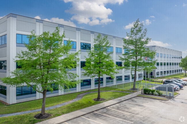
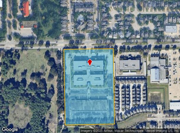
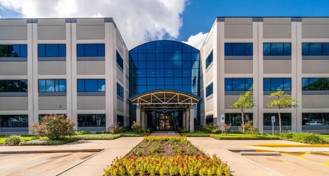
Property Record
10777 Clay Rd, Houston, TX 77041

Current Lease Availabilities
NEARBY LISTINGS FOR SALE OR LEASE
Property Detail
10777 Clay Rd
1228780010002
Paragon
Officebuilding
RES A1 BLK 1 PARAGON
X
Harris
48201C0635M
Texas
2024
11.31 AC
2025
Katy Freeway East
521900
Houston
344,658 SF
Houston-The Woodlands-Sugar Land, TX
DEMOGRAPHICS near 10777 Clay Rd
1 Mile
3 Mile
5 Mile
2024 Total Population
10,215
78,672
256,012
2029 Population
10,578
80,756
261,661
Pop Growth 2024-2029
+ 3.55%
+ 2.65%
+ 2.21%
Average Age
41
37
37
2024 Total Households
3,929
27,972
92,711
HH Growth 2024-2029
+ 3.89%
+ 2.71%
+ 2.27%
Median Household Inc
$66,488
$62,201
$68,118
Avg Household Size
2.50
2.70
2.70
2024 Avg HH Vehicles
2.00
2.00
2.00
Median Home Value
$260,510
$290,850
$308,792
Median Year Built
1982
1976
1979
Nearby Places
- Restaurants
- Banks
- Shops
- Fitness
- Groceries
PUBLIC TRANSPORTATION
AIRPORT
George Bush Intcntl/Houston
DRIVE
WALK
Distance
George Bush Intcntl/Houston
30 min
24.1 mi
William P Hobby
DRIVE
WALK
Distance
William P Hobby
45 min
28.5 mi
Freight Ports
Port of Houston
DRIVE
WALK
Distance
Port of Houston
36 min
24.1 mi
Nearby Properties
Address
Land Use
TOTAL SIZE
Lot Size
Zoning
Address
Land Use
TOTAL SIZE
Lot Size
Zoning
578,530 SF
32.81 AC
Address
Land Use
TOTAL SIZE
Lot Size
Zoning
793,669 SF
121.83 AC
Address
Land Use
TOTAL SIZE
Lot Size
Zoning
519,220 SF
6.23 AC
Address
Land Use
TOTAL SIZE
Lot Size
Zoning
342,163 SF
8.50 AC
Address
Land Use
TOTAL SIZE
Lot Size
Zoning
427,921 SF
18.14 AC
Address
Land Use
TOTAL SIZE
Lot Size
Zoning
336,681 SF
16.10 AC
Address
Land Use
TOTAL SIZE
Lot Size
Zoning
Address
Land Use
TOTAL SIZE
Lot Size
Zoning
300,348 SF
6.10 AC
Address
Land Use
TOTAL SIZE
Lot Size
Zoning
647,228 SF
9.85 AC
Address
Land Use
TOTAL SIZE
Lot Size
Zoning
408,730 SF
24.68 AC
Address
Land Use
TOTAL SIZE
Lot Size
Zoning
802,913 SF
27.11 AC
Address
Land Use
TOTAL SIZE
Lot Size
Zoning
281,843 SF
13.97 AC
Address
Land Use
TOTAL SIZE
Lot Size
Zoning
312,065 SF
17.83 AC
Address
Land Use
TOTAL SIZE
Lot Size
Zoning
157,698 SF
5.98 AC
Address
Land Use
TOTAL SIZE
Lot Size
Zoning
172,326 SF
8.07 AC
Address
Land Use
TOTAL SIZE
Lot Size
Zoning
350,057 SF
19.96 AC
Address
Land Use
TOTAL SIZE
Lot Size
Zoning
Address
Land Use
TOTAL SIZE
Lot Size
Zoning
287,212 SF
12.52 AC
Address
Land Use
TOTAL SIZE
Lot Size
Zoning
472,988 SF
9 AC
Address
Land Use
TOTAL SIZE
Lot Size
Zoning
212,017 SF
14.11 AC
Address
Land Use
TOTAL SIZE
Lot Size
Zoning
251,461 SF
21.74 AC
Address
Land Use
TOTAL SIZE
Lot Size
Zoning
418,892 SF
19.81 AC
Address
Land Use
TOTAL SIZE
Lot Size
Zoning
358,361 SF
11.35 AC
Address
Land Use
TOTAL SIZE
Lot Size
Zoning
272,209 SF
18.15 AC
Address
Land Use
TOTAL SIZE
Lot Size
Zoning
368,996 SF
21.47 AC
Address
Land Use
TOTAL SIZE
Lot Size
Zoning
415,860 SF
34.04 AC
Address
Land Use
TOTAL SIZE
Lot Size
Zoning
407,702 SF
15.73 AC
Address
Land Use
TOTAL SIZE
Lot Size
Zoning
308,148 SF
11.85 AC
Address
Land Use
TOTAL SIZE
Lot Size
Zoning
254,320 SF
22.03 AC
Address
Land Use
TOTAL SIZE
Lot Size
Zoning
272,263 SF
16.02 AC
The World's #1 Commercial Real Estate Marketplace
Connect with us
© 2025 CoStar Group
The information above has been obtained from sources believed reliable. While we do not doubt its accuracy we have not verified it and make no guarantee, warranty or representation about it. It is your responsibility to independently confirm its accuracy and completeness. Any projections, opinions, assumptions, or estimates used are for example only and do not represent the current or future performance of the property. The value of this transaction to you depends on tax and other factors which should be evaluated by your tax, financial, and legal advisors. You and your advisors should conduct a careful, independent investigation of the property to determine to your satisfaction the suitability of the property for your needs.