Property Record
1078 W Boylston St, Worcester, MA 01606
NEARBY LISTINGS FOR SALE OR LEASE
Property Detail
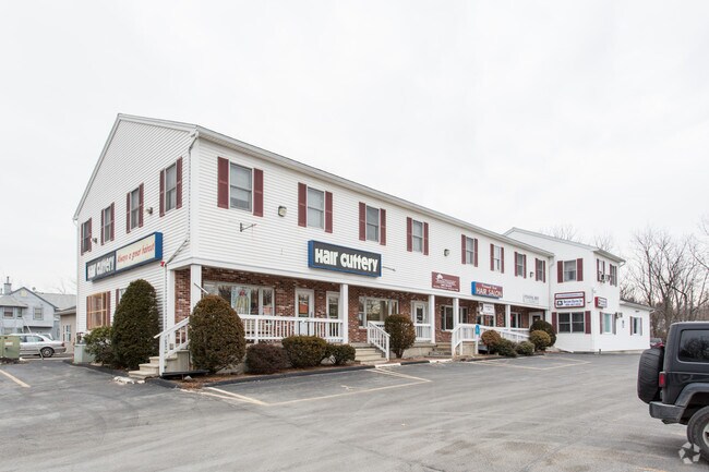
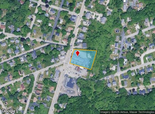
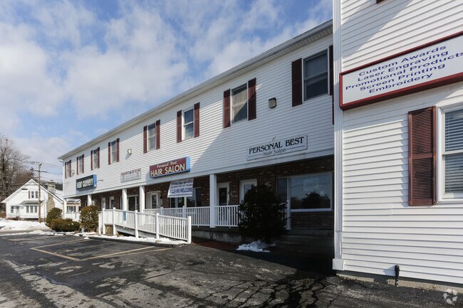
1078 W Boylston St
WORC-000032-000020-000033
West Boylston Gardens
Regionalshoppingcenterormallwithanchorstore
Worcester
X
Massachusetts
25027C0610F
33
2025
1.11 AC
2025
Worcester Metro
730200
Boston
14,320 SF
Worcester, MA-CT
DEMOGRAPHICS near 1078 W Boylston St
1 Mile
3 Mile
5 Mile
2024 Total Population
7,670
50,595
142,190
2029 Population
7,557
50,165
140,996
Pop Growth 2024-2029
(1.47%)
(0.85%)
(0.84%)
Average Age
43
41
40
2024 Total Households
3,104
19,826
55,619
HH Growth 2024-2029
(1.48%)
(0.92%)
(0.85%)
Median Household Inc
$90,465
$82,237
$79,403
Avg Household Size
2.30
2.40
2.40
2024 Avg HH Vehicles
2.00
2.00
2.00
Median Home Value
$321,646
$336,752
$376,605
Median Year Built
1958
1957
1958
Nearby Places
Map Layers
Map Styles
 Street
 Aerial
- Restaurants
- Banks
- Shops
- Fitness
- Groceries
PUBLIC TRANSPORTATION
COMMUTER RAIL
Worcester Union Station (Lake Shore Limited - Amtrak)
DRIVE
WALK
Distance
Worcester Union Station (Lake Shore Limited - Amtrak)
10 min
5.4 mi
Worcester (Framingham/Worcester Line - Massachusetts Bay Transportation Authority Commuter Rail (Purple Line))
DRIVE
WALK
Distance
Worcester (Framingham/Worcester Line - Massachusetts Bay Transportation Authority Commuter Rail (Purple Line))
10 min
5.4 mi
AIRPORT
Worcester Regional
DRIVE
WALK
Distance
Worcester Regional
19 min
9.0 mi
Freight Ports
Port of Boston
DRIVE
WALK
Distance
Port of Boston
68 min
45.3 mi
SALE & LEASE HISTORY
LISTING DATE
SALE/LEASE

May 26, 2020
For Lease
Jun 05, 2018
For Lease
Nearby Properties
Address
Land Use
TOTAL SIZE
Lot Size
Zoning
Address
Land Use
TOTAL SIZE
Lot Size
Zoning
155,421 SF
65.04 AC
RL-7
Address
Land Use
TOTAL SIZE
Lot Size
Zoning
524,527 SF
45.16 AC
BL-1
Address
Land Use
TOTAL SIZE
Lot Size
Zoning
51.05 AC
BO-1
Address
Land Use
TOTAL SIZE
Lot Size
Zoning
50.11 AC
RS-7
Address
Land Use
TOTAL SIZE
Lot Size
Zoning
126,849 SF
15.18 AC
R15
Address
Land Use
TOTAL SIZE
Lot Size
Zoning
30.93 AC
RG-5
Address
Land Use
TOTAL SIZE
Lot Size
Zoning
291,410 SF
21.73 AC
RL-7
Address
Land Use
TOTAL SIZE
Lot Size
Zoning
44,584 SF
90.22 AC
Address
Land Use
TOTAL SIZE
Lot Size
Zoning
15.37 AC
RS-7
Address
Land Use
TOTAL SIZE
Lot Size
Zoning
13.95 AC
RG-5
Address
Land Use
TOTAL SIZE
Lot Size
Zoning
286,338 SF
33.45 AC
RL-7
Address
Land Use
TOTAL SIZE
Lot Size
Zoning
153,482 SF
5.95 AC
MG-1
Address
Land Use
TOTAL SIZE
Lot Size
Zoning
6.70 AC
RG-5
Address
Land Use
TOTAL SIZE
Lot Size
Zoning
145,068 SF
16.35 AC
BG-3
Address
Land Use
TOTAL SIZE
Lot Size
Zoning
121,504 SF
3.75 AC
BG-3
Address
Land Use
TOTAL SIZE
Lot Size
Zoning
96,541 SF
5.24 AC
MG-5
Address
Land Use
TOTAL SIZE
Lot Size
Zoning
24,243 SF
168.59 AC
Address
Land Use
TOTAL SIZE
Lot Size
Zoning
29.20 AC
RS-7
Address
Land Use
TOTAL SIZE
Lot Size
Zoning
5.13 AC
RG-5
Address
Land Use
TOTAL SIZE
Lot Size
Zoning
5.67 AC
RG-5
Address
Land Use
TOTAL SIZE
Lot Size
Zoning
83,889 SF
12.47 AC
R20
Address
Land Use
TOTAL SIZE
Lot Size
Zoning
6.09 AC
RG-5
Address
Land Use
TOTAL SIZE
Lot Size
Zoning
83,148 SF
2.63 AC
ML-.5
Address
Land Use
TOTAL SIZE
Lot Size
Zoning
2,144 SF
8.14 AC
RG-5
Address
Land Use
TOTAL SIZE
Lot Size
Zoning
564,103 SF
27.39 AC
MG-1
Address
Land Use
TOTAL SIZE
Lot Size
Zoning
13 AC
RS-7
Address
Land Use
TOTAL SIZE
Lot Size
Zoning
47.19 AC
RL-7
Address
Land Use
TOTAL SIZE
Lot Size
Zoning
20.50 AC
LIM IN
Address
Land Use
TOTAL SIZE
Lot Size
Zoning
206,734 SF
13.49 AC
RS-7
Address
Land Use
TOTAL SIZE
Lot Size
Zoning
260,043 SF
15.23 AC
MG-1
The World's #1 Commercial Real Estate Marketplace
Connect with us
© 2025 CoStar Group
The information above has been obtained from sources believed reliable. While we do not doubt its accuracy we have not verified it and make no guarantee, warranty or representation about it. It is your responsibility to independently confirm its accuracy and completeness. Any projections, opinions, assumptions, or estimates used are for example only and do not represent the current or future performance of the property. The value of this transaction to you depends on tax and other factors which should be evaluated by your tax, financial, and legal advisors. You and your advisors should conduct a careful, independent investigation of the property to determine to your satisfaction the suitability of the property for your needs.