Property Record
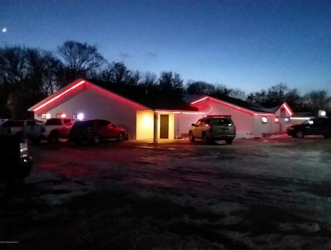
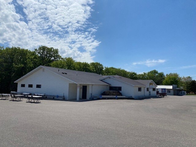
10790 County Highway 5, Pelican Rapids, MN 56572

Property Detail
10790 County Highway 5
R060497000
SEC 36 TWN 138 RNG 043 PT NW1/4 OF NW1/4 BEG 890' E & 736.19' S OF NW COR SEC 36; TH SW 130', SE 70', SW 71.82', SE 134.19',
Restaurantbuilding
Becker
COMMERCIAL
Minnesota
2026
0.92 AC
2025
Minnesota North Area
450900
Other Market Areas
5,537 SF
Detroit Lakes, MN
NEARBY LISTINGS FOR SALE OR LEASE
-
-
View all Pelican Rapids listings for sale on LoopNet.com
DEMOGRAPHICS near 10790 County Highway 5
1 mile
3 mile
5 mile
2025 Total Population
55
1,788
3,850
2030 Population
57
1,909
4,110
Pop Growth 2025-2030
+ 3.64%
+ 6.77%
+ 6.75%
Average Age
50
51
51
2025 Total Households
24
817
1,740
HH Growth 2025-2030
+ 4.17%
+ 6.98%
+ 7.01%
Median Household Inc
$96,874
$91,590
$91,235
Avg Household Size
2.10
2.20
2.20
2025 Avg HH Vehicles
2.00
2.00
2.00
Median Home Value
$613,636
$567,471
$556,233
Median Year Built
1994
1985
1986
Nearby Places
Map Layers
Map Styles
 Street
 Aerial
Layers
 Traffic
 Biking
Places
Listings with unknown addresses are not visible on the map
- Restaurants
- Banks
- Shops
- Fitness
- Groceries
SALE & LEASE HISTORY
LISTING DATE
SALE/LEASE

Oct 16, 2019
For Sale
Jun 15, 2020
For Sale
Jan 29, 2019
For Sale
Nearby Properties
Address
Land Use
TOTAL SIZE
Lot Size
Zoning
Address
Land Use
TOTAL SIZE
Lot Size
Zoning
62.43 AC
AGRICULTUR
Address
Land Use
TOTAL SIZE
Lot Size
Zoning
7,688 SF
10.26 AC
Address
Land Use
TOTAL SIZE
Lot Size
Zoning
2,528 SF
15.21 AC
COMMERCIAL
Address
Land Use
TOTAL SIZE
Lot Size
Zoning
3,072 SF
2.20 AC
COMMERCIAL
Address
Land Use
TOTAL SIZE
Lot Size
Zoning
21,600 SF
25.77 AC
Address
Land Use
TOTAL SIZE
Lot Size
Zoning
7,426 SF
1.42 AC
Address
Land Use
TOTAL SIZE
Lot Size
Zoning
7,465 SF
1.11 AC
AGRICULTUR
Address
Land Use
TOTAL SIZE
Lot Size
Zoning
7,000 SF
3.45 AC
AGRICULTUR
Address
Land Use
TOTAL SIZE
Lot Size
Zoning
11,480 SF
1.35 AC
Address
Land Use
TOTAL SIZE
Lot Size
Zoning
2,240 SF
40 AC
AGRICULTUR
Address
Land Use
TOTAL SIZE
Lot Size
Zoning
4,000 SF
0.69 AC
Address
Land Use
TOTAL SIZE
Lot Size
Zoning
5,608 SF
2.03 AC
COMMERCIAL
Address
Land Use
TOTAL SIZE
Lot Size
Zoning
Address
Land Use
TOTAL SIZE
Lot Size
Zoning
1,352 SF
5.95 AC
Address
Land Use
TOTAL SIZE
Lot Size
Zoning
336 SF
37.44 AC
AGRICULTUR
Address
Land Use
TOTAL SIZE
Lot Size
Zoning
Address
Land Use
TOTAL SIZE
Lot Size
Zoning
5.10 AC
AGRICULTUR
Address
Land Use
TOTAL SIZE
Lot Size
Zoning
12,330 SF
Address
Land Use
TOTAL SIZE
Lot Size
Zoning
72.73 AC
AGRICULTUR
Address
Land Use
TOTAL SIZE
Lot Size
Zoning
5.05 AC
AGRICULTUR
Address
Land Use
TOTAL SIZE
Lot Size
Zoning
2.30 AC
RESIDENTIA
Address
Land Use
TOTAL SIZE
Lot Size
Zoning
6,240 SF
38.12 AC
AGRICULTUR
Address
Land Use
TOTAL SIZE
Lot Size
Zoning
74.82 AC
AGRICULTUR
Address
Land Use
TOTAL SIZE
Lot Size
Zoning
8,820 SF
0.65 AC
AGRICULTUR
Address
Land Use
TOTAL SIZE
Lot Size
Zoning
320 SF
0.85 AC
AGRICULTUR
Address
Land Use
TOTAL SIZE
Lot Size
Zoning
60 AC
AGRICULTUR
Address
Land Use
TOTAL SIZE
Lot Size
Zoning
5,520 SF
3.64 AC
AGRICULTUR
Address
Land Use
TOTAL SIZE
Lot Size
Zoning
1,724 SF
24.94 AC
AGRICULTUR
Address
Land Use
TOTAL SIZE
Lot Size
Zoning
3,456 SF
0.53 AC
COMMERCIAL
The World's #1 Commercial Real Estate Marketplace
Connect with us
© 2026 CoStar Group
The information above has been obtained from sources believed reliable. While we do not doubt its accuracy we have not verified it and make no guarantee, warranty or representation about it. It is your responsibility to independently confirm its accuracy and completeness. Any projections, opinions, assumptions, or estimates used are for example only and do not represent the current or future performance of the property. The value of this transaction to you depends on tax and other factors which should be evaluated by your tax, financial, and legal advisors. You and your advisors should conduct a careful, independent investigation of the property to determine to your satisfaction the suitability of the property for your needs.