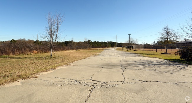
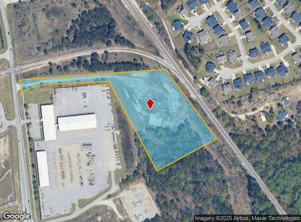
Property Record
10792 Farrow Rd, Blythewood, SC 29016

NEARBY LISTINGS FOR SALE OR LEASE
Property Detail
10792 Farrow Rd
Columbia, SC
4700 Acres
17600-02-54
LOT 1 96.2X959.6X561.5X440.7X811.8X 434.6X96.7X32.6X35.5 #SU
Commercialnec
Richland
X
South Carolina
45079C0137L
1,96
2025
6.47 AC
2024
Northeast Columbia
010106
Columbia
DEMOGRAPHICS near 10792 Farrow Rd
1 Mile
3 Mile
5 Mile
2024 Total Population
4,586
30,609
80,716
2029 Population
4,626
31,376
82,219
Pop Growth 2024-2029
+ 0.87%
+ 2.51%
+ 1.86%
Average Age
36
36
37
2024 Total Households
1,500
10,880
29,805
HH Growth 2024-2029
+ 0.93%
+ 2.65%
+ 1.88%
Median Household Inc
$77,373
$79,460
$73,712
Avg Household Size
3.00
2.80
2.70
2024 Avg HH Vehicles
2.00
2.00
2.00
Median Home Value
$204,683
$239,932
$220,564
Median Year Built
2007
2007
2004
Nearby Places
Map Layers
Map Styles
 Street
 Aerial
- Restaurants
- Banks
- Shops
- Fitness
- Groceries
PUBLIC TRANSPORTATION
AIRPORT
Columbia Metro
DRIVE
WALK
Distance
Columbia Metro
44 min
26.8 mi
Freight Ports
North Charleston Terminal
DRIVE
WALK
Distance
North Charleston Terminal
143 min
123.9 mi
SALE & LEASE HISTORY
LISTING DATE
SALE/LEASE

Sep 24, 2016
For Sale
Mar 03, 2017
For Sale
Nearby Properties
Address
Land Use
TOTAL SIZE
Lot Size
Zoning
Address
Land Use
TOTAL SIZE
Lot Size
Zoning
231,760 SF
23.84 AC
M-1
Address
Land Use
TOTAL SIZE
Lot Size
Zoning
18,000 SF
52.20 AC
GC
Address
Land Use
TOTAL SIZE
Lot Size
Zoning
33.32 AC
M-1
Address
Land Use
TOTAL SIZE
Lot Size
Zoning
306,612 SF
20.94 AC
GC
Address
Land Use
TOTAL SIZE
Lot Size
Zoning
349,845 SF
23.62 AC
HI
Address
Land Use
TOTAL SIZE
Lot Size
Zoning
232,148 SF
14.16 AC
PDD
Address
Land Use
TOTAL SIZE
Lot Size
Zoning
462,800 SF
104.82 AC
M-1
Address
Land Use
TOTAL SIZE
Lot Size
Zoning
253,136 SF
18.85 AC
PUD-1R
Address
Land Use
TOTAL SIZE
Lot Size
Zoning
269,200 SF
40.65 AC
M-1
Address
Land Use
TOTAL SIZE
Lot Size
Zoning
176,878 SF
15.48 AC
PDD
Address
Land Use
TOTAL SIZE
Lot Size
Zoning
51,803 SF
11.99 AC
M-1
Address
Land Use
TOTAL SIZE
Lot Size
Zoning
217,580 SF
32.47 AC
M-1
Address
Land Use
TOTAL SIZE
Lot Size
Zoning
65,665 SF
7.03 AC
GC
Address
Land Use
TOTAL SIZE
Lot Size
Zoning
184,000 SF
9.67 AC
M-1
Address
Land Use
TOTAL SIZE
Lot Size
Zoning
275,753 SF
26.21 AC
HI
Address
Land Use
TOTAL SIZE
Lot Size
Zoning
178,080 SF
10.48 AC
M-1
Address
Land Use
TOTAL SIZE
Lot Size
Zoning
148,809 SF
17.52 AC
M-1
Address
Land Use
TOTAL SIZE
Lot Size
Zoning
129,017 SF
14.70 AC
PDD
Address
Land Use
TOTAL SIZE
Lot Size
Zoning
75,893 SF
10 AC
PDD
Address
Land Use
TOTAL SIZE
Lot Size
Zoning
169,600 SF
10.80 AC
M-1
Address
Land Use
TOTAL SIZE
Lot Size
Zoning
52,568 SF
1.93 AC
D-1
Address
Land Use
TOTAL SIZE
Lot Size
Zoning
73,901 SF
8.83 AC
PUD
Address
Land Use
TOTAL SIZE
Lot Size
Zoning
72,549 SF
2.49 AC
PDD
Address
Land Use
TOTAL SIZE
Lot Size
Zoning
37,971 SF
8.40 AC
PDD
Address
Land Use
TOTAL SIZE
Lot Size
Zoning
42,938 SF
7.30 AC
HI
Address
Land Use
TOTAL SIZE
Lot Size
Zoning
103,719 SF
4.05 AC
RM-HD
Address
Land Use
TOTAL SIZE
Lot Size
Zoning
2,740 SF
5 AC
D-1
Address
Land Use
TOTAL SIZE
Lot Size
Zoning
74,014 SF
22.02 AC
HI
Address
Land Use
TOTAL SIZE
Lot Size
Zoning
7,700 SF
6.89 AC
PDD
Address
Land Use
TOTAL SIZE
Lot Size
Zoning
112,228 SF
20.34 AC
M-1
The World's #1 Commercial Real Estate Marketplace
Connect with us
© 2025 CoStar Group
The information above has been obtained from sources believed reliable. While we do not doubt its accuracy we have not verified it and make no guarantee, warranty or representation about it. It is your responsibility to independently confirm its accuracy and completeness. Any projections, opinions, assumptions, or estimates used are for example only and do not represent the current or future performance of the property. The value of this transaction to you depends on tax and other factors which should be evaluated by your tax, financial, and legal advisors. You and your advisors should conduct a careful, independent investigation of the property to determine to your satisfaction the suitability of the property for your needs.