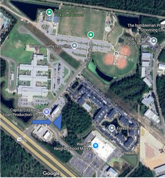
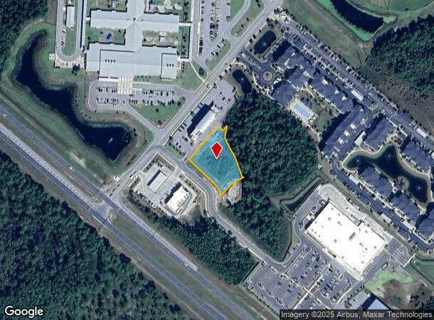
Property Record
108 Mc Davis Blvd, Santa Rosa Beach, FL 32459
Current Lease Availabilities
NEARBY LISTINGS FOR SALE OR LEASE
Property Detail
108 Mc Davis Blvd
Crestview-Fort Walton Beach-Destin, FL
COM NW/COR SEC 5-3S-18W,S 20 DEG 3557E 4344.81 FT FOR POB S 49 DEG 0941E 33.25 FT,N 40 DEG 5019E 27.50 FT,S 06 DEG 1422W 47.25 FT,S 25 DEG 11 12E 52.13 FT,S 27 DEG 1402E 49.68 FT,S 20 DEG 5424E 100.01 FT,S 28 DEG 5505E 6.87 FT,S 64 DEG 4151W 63.32 FT
05-3S-18-16000-001-0026
Walton
Vacantlandnec
Florida
A
26
12131C0677H
0.94 AC
2025
Florida Panhandle Area
2025
Other Market Areas
950610
DEMOGRAPHICS near 108 Mc Davis Blvd
1 Mile
3 Mile
5 Mile
2024 Total Population
311
3,563
14,016
2029 Population
362
4,358
17,161
Pop Growth 2024-2029
+ 16.40%
+ 22.31%
+ 22.44%
Average Age
40
45
46
2024 Total Households
118
1,494
5,947
HH Growth 2024-2029
+ 16.10%
+ 22.16%
+ 22.21%
Median Household Inc
$119,444
$121,407
$121,714
Avg Household Size
2.60
2.30
2.30
2024 Avg HH Vehicles
2.00
2.00
2.00
Median Home Value
$490,475
$837,871
$862,640
Median Year Built
2011
2009
2007
Nearby Places
- Restaurants
- Banks
- Shops
- Fitness
- Groceries
PUBLIC TRANSPORTATION
AIRPORT
Northwest Florida Beaches International
DRIVE
WALK
Distance
Northwest Florida Beaches International
38 min
26.4 mi
Eglin AFB/Destin-Ft Walton Beach
DRIVE
WALK
Distance
Eglin AFB/Destin-Ft Walton Beach
77 min
39.4 mi
Freight Ports
Port of Panama City
DRIVE
WALK
Distance
Port of Panama City
38 min
24.7 mi
Nearby Properties
Address
Land Use
TOTAL SIZE
Lot Size
Zoning
Address
Land Use
TOTAL SIZE
Lot Size
Zoning
750 SF
197.50 AC
Address
Land Use
TOTAL SIZE
Lot Size
Zoning
314,974 SF
12.95 AC
GC
Address
Land Use
TOTAL SIZE
Lot Size
Zoning
161,276 SF
33.57 AC
HWY 98
Address
Land Use
TOTAL SIZE
Lot Size
Zoning
143,381 SF
40 AC
Address
Land Use
TOTAL SIZE
Lot Size
Zoning
1,864 SF
287.23 AC
Address
Land Use
TOTAL SIZE
Lot Size
Zoning
125,112 SF
5.50 AC
CR21
Address
Land Use
TOTAL SIZE
Lot Size
Zoning
65,396 SF
17.87 AC
HWY 98
Address
Land Use
TOTAL SIZE
Lot Size
Zoning
86,940 SF
1.95 AC
Address
Land Use
TOTAL SIZE
Lot Size
Zoning
15,945 SF
1.57 AC
Address
Land Use
TOTAL SIZE
Lot Size
Zoning
Address
Land Use
TOTAL SIZE
Lot Size
Zoning
96,048 SF
65 AC
HWY 98
Address
Land Use
TOTAL SIZE
Lot Size
Zoning
29,513 SF
3.10 AC
Address
Land Use
TOTAL SIZE
Lot Size
Zoning
100,059 SF
2.01 AC
HWY 98
Address
Land Use
TOTAL SIZE
Lot Size
Zoning
6,948 SF
1.62 AC
NI
Address
Land Use
TOTAL SIZE
Lot Size
Zoning
2,947 SF
3.48 AC
SN
Address
Land Use
TOTAL SIZE
Lot Size
Zoning
Address
Land Use
TOTAL SIZE
Lot Size
Zoning
31,840 SF
5.99 AC
HWY 98
Address
Land Use
TOTAL SIZE
Lot Size
Zoning
21,490 SF
3.77 AC
Address
Land Use
TOTAL SIZE
Lot Size
Zoning
Address
Land Use
TOTAL SIZE
Lot Size
Zoning
42,341 SF
21.20 AC
HWY 98
Address
Land Use
TOTAL SIZE
Lot Size
Zoning
21,227 SF
1.20 AC
Address
Land Use
TOTAL SIZE
Lot Size
Zoning
14,130 SF
1.70 AC
HWY 98
Address
Land Use
TOTAL SIZE
Lot Size
Zoning
1,716 SF
402 AC
HWY 98
Address
Land Use
TOTAL SIZE
Lot Size
Zoning
29,255 SF
1.55 AC
BP
Address
Land Use
TOTAL SIZE
Lot Size
Zoning
561.96 AC
HWY 98
Address
Land Use
TOTAL SIZE
Lot Size
Zoning
587.80 AC
HWY 98
Address
Land Use
TOTAL SIZE
Lot Size
Zoning
11,463 SF
2.09 AC
HWY 98
Address
Land Use
TOTAL SIZE
Lot Size
Zoning
21,514 SF
1.96 AC
HWY 98
Address
Land Use
TOTAL SIZE
Lot Size
Zoning
19,638 SF
1.86 AC
Address
Land Use
TOTAL SIZE
Lot Size
Zoning
The World's #1 Commercial Real Estate Marketplace
Connect with us
© 2025 CoStar Group
The information above has been obtained from sources believed reliable. While we do not doubt its accuracy we have not verified it and make no guarantee, warranty or representation about it. It is your responsibility to independently confirm its accuracy and completeness. Any projections, opinions, assumptions, or estimates used are for example only and do not represent the current or future performance of the property. The value of this transaction to you depends on tax and other factors which should be evaluated by your tax, financial, and legal advisors. You and your advisors should conduct a careful, independent investigation of the property to determine to your satisfaction the suitability of the property for your needs.