Property Record
108 Milk St, Westborough, MA 01581
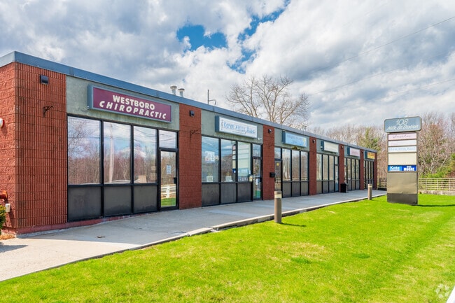
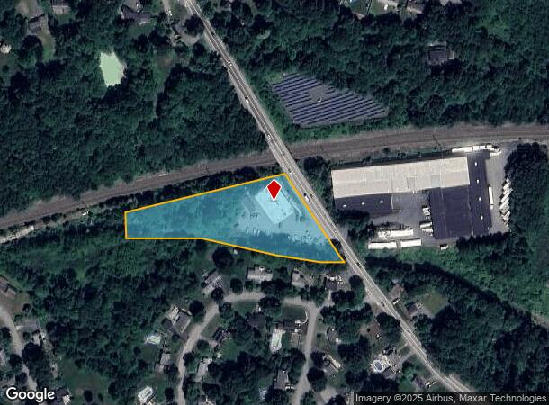
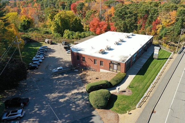
This Property Is For Sale
Current Lease Availabilities
NEARBY LISTINGS FOR SALE OR LEASE
Property Detail
108 Milk St
Regionalshoppingcenterormallwithanchorstore
Worcester
X
Massachusetts
25027C0644F
2.34 AC
2025
The Boroughs
2025
Boston
742300
Worcester, MA-CT
9,586 SF
WBOR-000027-000211
DEMOGRAPHICS near 108 Milk St
1 Mile
3 Mile
5 Mile
2024 Total Population
5,452
31,104
73,879
2029 Population
5,444
31,125
73,996
Pop Growth 2024-2029
(0.15%)
+ 0.07%
+ 0.16%
Average Age
43
40
40
2024 Total Households
2,283
11,310
26,964
HH Growth 2024-2029
(0.04%)
+ 0.08%
+ 0.22%
Median Household Inc
$105,967
$132,567
$135,821
Avg Household Size
2.20
2.70
2.70
2024 Avg HH Vehicles
2.00
2.00
2.00
Median Home Value
$454,174
$550,103
$584,633
Median Year Built
1955
1979
1982
Nearby Places
Map Layers
Map Styles
 Street
 Aerial
- Restaurants
- Banks
- Shops
- Fitness
- Groceries
PUBLIC TRANSPORTATION
COMMUTER RAIL
Westborough (Framingham/Worcester Line - Massachusetts Bay Transportation Authority Commuter Rail (Purple Line))
DRIVE
WALK
Distance
Westborough (Framingham/Worcester Line - Massachusetts Bay Transportation Authority Commuter Rail (Purple Line))
5 min
1.9 mi
Grafton (Framingham/Worcester Line - Massachusetts Bay Transportation Authority Commuter Rail (Purple Line))
DRIVE
WALK
Distance
Grafton (Framingham/Worcester Line - Massachusetts Bay Transportation Authority Commuter Rail (Purple Line))
11 min
4.8 mi
AIRPORT
Worcester Regional
DRIVE
WALK
Distance
Worcester Regional
28 min
15.0 mi
General Edward Lawrence Logan International
DRIVE
WALK
Distance
General Edward Lawrence Logan International
51 min
36.2 mi
Freight Ports
Port of Boston
DRIVE
WALK
Distance
Port of Boston
50 min
34.5 mi
Nearby Properties
Address
Land Use
TOTAL SIZE
Lot Size
Zoning
Address
Land Use
TOTAL SIZE
Lot Size
Zoning
42.01 AC
I
Address
Land Use
TOTAL SIZE
Lot Size
Zoning
274,000 SF
32 AC
M-1
Address
Land Use
TOTAL SIZE
Lot Size
Zoning
67.29 AC
IB
Address
Land Use
TOTAL SIZE
Lot Size
Zoning
23.65 AC
RUR A
Address
Land Use
TOTAL SIZE
Lot Size
Zoning
19.69 AC
BA
Address
Land Use
TOTAL SIZE
Lot Size
Zoning
205,712 SF
3.95 AC
BA
Address
Land Use
TOTAL SIZE
Lot Size
Zoning
320,540 SF
20.02 AC
BA
Address
Land Use
TOTAL SIZE
Lot Size
Zoning
201,818 SF
5.55 AC
BA
Address
Land Use
TOTAL SIZE
Lot Size
Zoning
205,712 SF
5.76 AC
BA
Address
Land Use
TOTAL SIZE
Lot Size
Zoning
107,308 SF
45.40 AC
M-1
Address
Land Use
TOTAL SIZE
Lot Size
Zoning
15.20 AC
BA
Address
Land Use
TOTAL SIZE
Lot Size
Zoning
677,238 SF
92.81 AC
IB
Address
Land Use
TOTAL SIZE
Lot Size
Zoning
260,605 SF
29 AC
I
Address
Land Use
TOTAL SIZE
Lot Size
Zoning
299,149 SF
28.81 AC
I
Address
Land Use
TOTAL SIZE
Lot Size
Zoning
43.90 AC
M-1
Address
Land Use
TOTAL SIZE
Lot Size
Zoning
21.04 AC
APT 99
Address
Land Use
TOTAL SIZE
Lot Size
Zoning
10.28 AC
R
Address
Land Use
TOTAL SIZE
Lot Size
Zoning
170,000 SF
27.66 AC
BA
Address
Land Use
TOTAL SIZE
Lot Size
Zoning
32.51 AC
IB
Address
Land Use
TOTAL SIZE
Lot Size
Zoning
296,330 SF
24.88 AC
IB
Address
Land Use
TOTAL SIZE
Lot Size
Zoning
108,038 SF
19.68 AC
M-1
Address
Land Use
TOTAL SIZE
Lot Size
Zoning
125,914 SF
111.02 AC
Address
Land Use
TOTAL SIZE
Lot Size
Zoning
19.05 AC
I
Address
Land Use
TOTAL SIZE
Lot Size
Zoning
22.06 AC
COM BU
Address
Land Use
TOTAL SIZE
Lot Size
Zoning
216,518 SF
6.64 AC
R
Address
Land Use
TOTAL SIZE
Lot Size
Zoning
97,171 SF
27.77 AC
M-1
Address
Land Use
TOTAL SIZE
Lot Size
Zoning
157,014 SF
111.02 AC
Address
Land Use
TOTAL SIZE
Lot Size
Zoning
184,960 SF
23.58 AC
IB
Address
Land Use
TOTAL SIZE
Lot Size
Zoning
124,262 SF
Address
Land Use
TOTAL SIZE
Lot Size
Zoning
7,387 SF
109.70 AC
M-1
The World's #1 Commercial Real Estate Marketplace
Connect with us
© 2025 CoStar Group
The information above has been obtained from sources believed reliable. While we do not doubt its accuracy we have not verified it and make no guarantee, warranty or representation about it. It is your responsibility to independently confirm its accuracy and completeness. Any projections, opinions, assumptions, or estimates used are for example only and do not represent the current or future performance of the property. The value of this transaction to you depends on tax and other factors which should be evaluated by your tax, financial, and legal advisors. You and your advisors should conduct a careful, independent investigation of the property to determine to your satisfaction the suitability of the property for your needs.