Property Record
108 N Lacy Dr, Waco, TX 76705

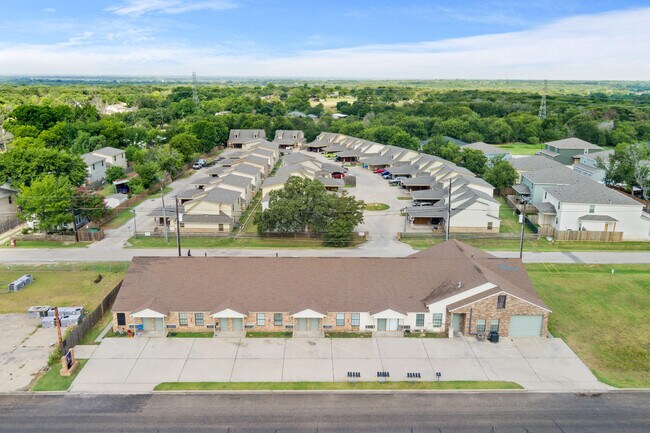
Property Detail
108 N Lacy Dr
20-021313-000102-0
BRISTOL TERRACE LOT 1 BLOCK 1 ACRES .1934
Apartment
McLennan
C
Texas
B and X Area of moderate flood hazard, usually the area between the limits of the 100-year and 500-year floods.
1
2024
0.20 AC
2025
Waco
003200
Other Market Areas
6,204 SF
Waco, TX
NEARBY LISTINGS FOR SALE OR LEASE
-
-
View all Waco listings for sale on LoopNet.com
DEMOGRAPHICS near 108 N Lacy Dr
1 mile
3 mile
5 mile
2025 Total Population
5,397
26,277
51,243
2030 Population
5,620
27,306
53,316
Pop Growth 2025-2030
+ 4.13%
+ 3.92%
+ 4.05%
Average Age
37
36
37
2025 Total Households
2,168
9,530
19,009
HH Growth 2025-2030
+ 4.20%
+ 3.99%
+ 4.18%
Median Household Inc
$44,562
$52,643
$45,682
Avg Household Size
2.40
2.60
2.50
2025 Avg HH Vehicles
2.00
2.00
2.00
Median Home Value
$163,108
$173,963
$180,930
Median Year Built
1981
1980
1977
Nearby Places
Map Layers
Map Styles
 Street
 Aerial
Layers
 Traffic
 Biking
Places
Listings with unknown addresses are not visible on the map
- Restaurants
- Banks
- Shops
- Fitness
- Groceries
PUBLIC TRANSPORTATION
AIRPORT
Waco Regional
Drive
Walk
Distance
Waco Regional
21 min
9.9 mi
Freight Ports
Port of Houston
Drive
Walk
Distance
Port of Houston
217 min
188.0 mi
SALE & LEASE HISTORY
LISTING DATE
SALE/LEASE

Jul 29, 2024
For Sale
Nearby Properties
Address
Land Use
TOTAL SIZE
Lot Size
Zoning
Address
Land Use
TOTAL SIZE
Lot Size
Zoning
821,607 SF
48.98 AC
Address
Land Use
TOTAL SIZE
Lot Size
Zoning
193,246 SF
144.87 AC
R
Address
Land Use
TOTAL SIZE
Lot Size
Zoning
215,433 SF
33.17 AC
R
Address
Land Use
TOTAL SIZE
Lot Size
Zoning
Address
Land Use
TOTAL SIZE
Lot Size
Zoning
Address
Land Use
TOTAL SIZE
Lot Size
Zoning
Address
Land Use
TOTAL SIZE
Lot Size
Zoning
30.89 AC
R1
Address
Land Use
TOTAL SIZE
Lot Size
Zoning
33,442 SF
2.80 AC
Address
Land Use
TOTAL SIZE
Lot Size
Zoning
127,979 SF
5.72 AC
R
Address
Land Use
TOTAL SIZE
Lot Size
Zoning
186,588 SF
10.28 AC
C1
Address
Land Use
TOTAL SIZE
Lot Size
Zoning
21.76 AC
R
Address
Land Use
TOTAL SIZE
Lot Size
Zoning
13.72 AC
R1
Address
Land Use
TOTAL SIZE
Lot Size
Zoning
8.86 AC
R1
Address
Land Use
TOTAL SIZE
Lot Size
Zoning
87,206 SF
2.80 AC
Address
Land Use
TOTAL SIZE
Lot Size
Zoning
202,787 SF
22.33 AC
B2
Address
Land Use
TOTAL SIZE
Lot Size
Zoning
Address
Land Use
TOTAL SIZE
Lot Size
Zoning
229,166 SF
14.18 AC
C
Address
Land Use
TOTAL SIZE
Lot Size
Zoning
Address
Land Use
TOTAL SIZE
Lot Size
Zoning
132,772 SF
27.36 AC
C
Address
Land Use
TOTAL SIZE
Lot Size
Zoning
125,412 SF
8.37 AC
R
Address
Land Use
TOTAL SIZE
Lot Size
Zoning
99,796 SF
11.13 AC
R
Address
Land Use
TOTAL SIZE
Lot Size
Zoning
102,480 SF
9.36 AC
R4
Address
Land Use
TOTAL SIZE
Lot Size
Zoning
Address
Land Use
TOTAL SIZE
Lot Size
Zoning
68,942 SF
2.13 AC
C1
Address
Land Use
TOTAL SIZE
Lot Size
Zoning
69,642 SF
27.76 AC
R1B
Address
Land Use
TOTAL SIZE
Lot Size
Zoning
99,124 SF
5 AC
B2
Address
Land Use
TOTAL SIZE
Lot Size
Zoning
Address
Land Use
TOTAL SIZE
Lot Size
Zoning
47.44 AC
Address
Land Use
TOTAL SIZE
Lot Size
Zoning
55,756 SF
7.72 AC
R
Address
Land Use
TOTAL SIZE
Lot Size
Zoning
67,229 SF
3.22 AC
R
The World's #1 Commercial Real Estate Marketplace
Connect with us
© 2026 CoStar Group
The information above has been obtained from sources believed reliable. While we do not doubt its accuracy we have not verified it and make no guarantee, warranty or representation about it. It is your responsibility to independently confirm its accuracy and completeness. Any projections, opinions, assumptions, or estimates used are for example only and do not represent the current or future performance of the property. The value of this transaction to you depends on tax and other factors which should be evaluated by your tax, financial, and legal advisors. You and your advisors should conduct a careful, independent investigation of the property to determine to your satisfaction the suitability of the property for your needs.