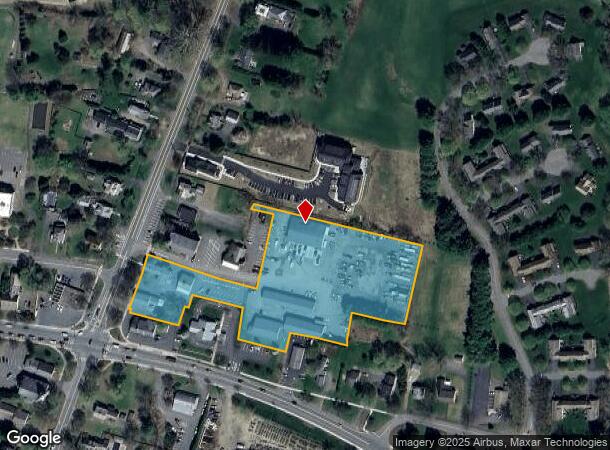
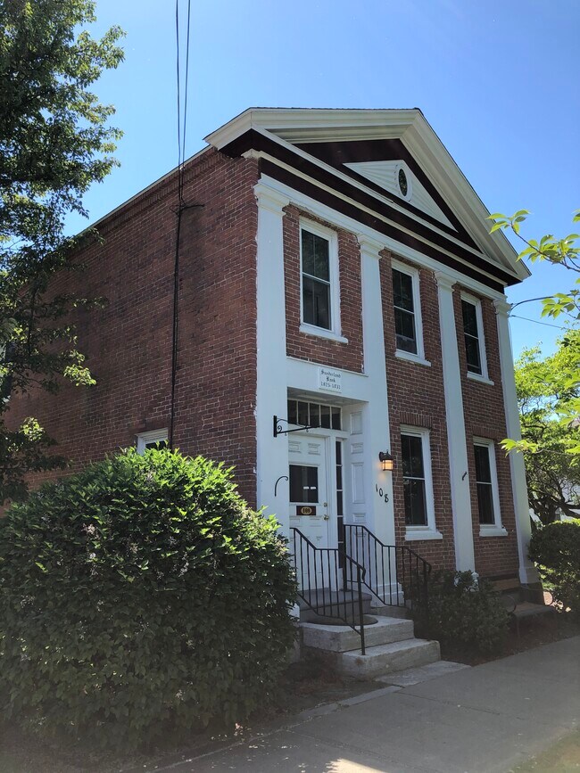
Property Record
108 N Main St, Sunderland, MA 01375

NEARBY LISTINGS FOR SALE OR LEASE
Property Detail
108 N Main St
Greenfield Town, MA
Franklin
SUND-000006-000000-000052
Massachusetts
Commercialnec
52
2025
4.12 AC
2025
Franklin County
040800
Hartford
1,170 SF
DEMOGRAPHICS near 108 N Main St
1 Mile
3 Mile
5 Mile
2024 Total Population
1,583
6,317
14,793
2029 Population
1,580
6,219
13,644
Pop Growth 2024-2029
(0.19%)
(1.55%)
(7.77%)
Average Age
40
43
42
2024 Total Households
749
2,860
6,344
HH Growth 2024-2029
(0.27%)
(1.50%)
(7.63%)
Median Household Inc
$57,039
$74,857
$78,192
Avg Household Size
2.10
2.20
2.20
2024 Avg HH Vehicles
2.00
2.00
2.00
Median Home Value
$370,992
$371,535
$384,172
Median Year Built
1974
1974
1975
Nearby Places
Map Layers
Map Styles
 Street
 Aerial
- Restaurants
- Banks
- Shops
- Fitness
- Groceries
SALE & LEASE HISTORY
LISTING DATE
SALE/LEASE

Jun 26, 2020
For Lease
Nearby Properties
Address
Land Use
TOTAL SIZE
Lot Size
Zoning
Address
Land Use
TOTAL SIZE
Lot Size
Zoning
168,500 SF
18.25 AC
C+I
Address
Land Use
TOTAL SIZE
Lot Size
Zoning
28.93 AC
C1WD
Address
Land Use
TOTAL SIZE
Lot Size
Zoning
20.89 AC
CVR
Address
Land Use
TOTAL SIZE
Lot Size
Zoning
256,340 SF
31.71 AC
I
Address
Land Use
TOTAL SIZE
Lot Size
Zoning
9.23 AC
CII
Address
Land Use
TOTAL SIZE
Lot Size
Zoning
18 AC
CVR
Address
Land Use
TOTAL SIZE
Lot Size
Zoning
9.12 AC
VR
Address
Land Use
TOTAL SIZE
Lot Size
Zoning
5.93 AC
VR
Address
Land Use
TOTAL SIZE
Lot Size
Zoning
208,790 SF
44 AC
CI
Address
Land Use
TOTAL SIZE
Lot Size
Zoning
71,742 SF
11.70 AC
CVR
Address
Land Use
TOTAL SIZE
Lot Size
Zoning
9.65 AC
C+I
Address
Land Use
TOTAL SIZE
Lot Size
Zoning
81,138 SF
10.21 AC
I
Address
Land Use
TOTAL SIZE
Lot Size
Zoning
243,750 SF
15.80 AC
MMO
Address
Land Use
TOTAL SIZE
Lot Size
Zoning
12.14 AC
I
Address
Land Use
TOTAL SIZE
Lot Size
Zoning
8.82 AC
MMO
Address
Land Use
TOTAL SIZE
Lot Size
Zoning
142,167 SF
10 AC
Address
Land Use
TOTAL SIZE
Lot Size
Zoning
61,950 SF
5.59 AC
CII
Address
Land Use
TOTAL SIZE
Lot Size
Zoning
4.99 AC
C+I
Address
Land Use
TOTAL SIZE
Lot Size
Zoning
3,444 SF
2.21 AC
RA
Address
Land Use
TOTAL SIZE
Lot Size
Zoning
42,903 SF
22.73 AC
C+I
Address
Land Use
TOTAL SIZE
Lot Size
Zoning
100,072 SF
7.97 AC
EP
Address
Land Use
TOTAL SIZE
Lot Size
Zoning
726.31 AC
RR
Address
Land Use
TOTAL SIZE
Lot Size
Zoning
7.64 AC
MMO
Address
Land Use
TOTAL SIZE
Lot Size
Zoning
7.95 AC
I
Address
Land Use
TOTAL SIZE
Lot Size
Zoning
14.79 AC
R4
Address
Land Use
TOTAL SIZE
Lot Size
Zoning
99,595 SF
47 AC
R4
Address
Land Use
TOTAL SIZE
Lot Size
Zoning
1,476 SF
43.50 AC
RRWD
Address
Land Use
TOTAL SIZE
Lot Size
Zoning
12.70 AC
CVR
Address
Land Use
TOTAL SIZE
Lot Size
Zoning
990 SF
RRPA
Address
Land Use
TOTAL SIZE
Lot Size
Zoning
6.10 AC
CI
The World's #1 Commercial Real Estate Marketplace
Connect with us
© 2026 CoStar Group
The information above has been obtained from sources believed reliable. While we do not doubt its accuracy we have not verified it and make no guarantee, warranty or representation about it. It is your responsibility to independently confirm its accuracy and completeness. Any projections, opinions, assumptions, or estimates used are for example only and do not represent the current or future performance of the property. The value of this transaction to you depends on tax and other factors which should be evaluated by your tax, financial, and legal advisors. You and your advisors should conduct a careful, independent investigation of the property to determine to your satisfaction the suitability of the property for your needs.