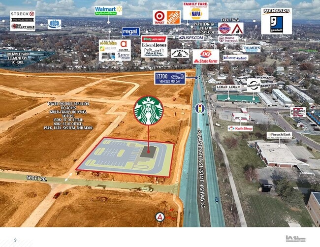
Property Record
108 Scott Rd, Papillion, NE 68046


Save to a Folder
{{folder.Name}}
{{folder.ListingIds.length}} Properties
{{folder.ListingIds.length}} Property
Create a New Folder
Property Detail
108 Scott Rd
Omaha, NE-IA
LOT 1 HIGHWAY 370 MIXED-USE DEVELOPMENT REPLAT 1
011617462
SARPY
Commercialnec
Nebraska
B and X Area of moderate flood hazard, usually the area between the limits of the 100-year and 500-year floods.
1
2024
0.91 AC
2025
Sarpy East
010623
Omaha/Council Bluffs
NEARBY LISTINGS FOR SALE OR LEASE
DEMOGRAPHICS near 108 Scott Rd
1 mile
3 mile
5 mile
2025 Total Population
11,802
57,117
134,492
2030 Population
12,516
61,255
142,384
Pop Growth 2025-2030
+ 6.05%
+ 7.24%
+ 5.87%
Average Age
38
38
38
2025 Total Households
4,378
20,913
52,067
HH Growth 2025-2030
+ 6.37%
+ 7.45%
+ 5.90%
Median Household Inc
$96,921
$108,777
$93,579
Avg Household Size
2.60
2.70
2.50
2025 Avg HH Vehicles
2.00
2.00
2.00
Median Home Value
$292,216
$350,451
$302,297
Median Year Built
1987
1998
1990
Nearby Places
Map Layers
Map Styles
 Street
 Aerial
Layers
 Traffic
 Biking
Places
Listings with unknown addresses are not visible on the map
- Restaurants
- Banks
- Shops
- Fitness
- Groceries
PUBLIC TRANSPORTATION
AIRPORT
Eppley Airfield
Drive
Walk
Distance
Eppley Airfield
30 min
19.4 mi
Freight Ports
Tulsa Port Of Catoosa
Drive
Walk
Distance
Tulsa Port Of Catoosa
460 min
415.4 mi
SALE & LEASE HISTORY
LISTING DATE
SALE/LEASE

Jan 30, 2025
For Sale
Jan 14, 2025
For Sale
Jan 06, 2025
For Sale
Nearby Properties
Address
Land Use
TOTAL SIZE
Lot Size
Zoning
Address
Land Use
TOTAL SIZE
Lot Size
Zoning
483,925 SF
42.06 AC
Address
Land Use
TOTAL SIZE
Lot Size
Zoning
28,401 SF
27.31 AC
Address
Land Use
TOTAL SIZE
Lot Size
Zoning
25,204 SF
2.34 AC
R4
Address
Land Use
TOTAL SIZE
Lot Size
Zoning
28,820 SF
16.81 AC
Address
Land Use
TOTAL SIZE
Lot Size
Zoning
46,886 SF
19.29 AC
Address
Land Use
TOTAL SIZE
Lot Size
Zoning
28,913 SF
2.04 AC
Address
Land Use
TOTAL SIZE
Lot Size
Zoning
294,672 SF
15.06 AC
Address
Land Use
TOTAL SIZE
Lot Size
Zoning
13,930 SF
1.04 AC
Address
Land Use
TOTAL SIZE
Lot Size
Zoning
88,545 SF
9.58 AC
Address
Land Use
TOTAL SIZE
Lot Size
Zoning
6,210 SF
8.28 AC
Address
Land Use
TOTAL SIZE
Lot Size
Zoning
2,610 SF
9.96 AC
Address
Land Use
TOTAL SIZE
Lot Size
Zoning
1,356 SF
415.31 AC
Address
Land Use
TOTAL SIZE
Lot Size
Zoning
8,649 SF
17.76 AC
Address
Land Use
TOTAL SIZE
Lot Size
Zoning
37,196 SF
13.96 AC
MU
Address
Land Use
TOTAL SIZE
Lot Size
Zoning
18,484 SF
5.47 AC
Address
Land Use
TOTAL SIZE
Lot Size
Zoning
11,244 SF
6.91 AC
Address
Land Use
TOTAL SIZE
Lot Size
Zoning
217,511 SF
25.06 AC
Address
Land Use
TOTAL SIZE
Lot Size
Zoning
149,713 SF
10.46 AC
Address
Land Use
TOTAL SIZE
Lot Size
Zoning
11,889 SF
5.58 AC
Address
Land Use
TOTAL SIZE
Lot Size
Zoning
196,746 SF
10.22 AC
Address
Land Use
TOTAL SIZE
Lot Size
Zoning
96,970 SF
9.68 AC
Address
Land Use
TOTAL SIZE
Lot Size
Zoning
6,472 SF
4.58 AC
Address
Land Use
TOTAL SIZE
Lot Size
Zoning
130,245 SF
6.93 AC
Address
Land Use
TOTAL SIZE
Lot Size
Zoning
7,448 SF
4.71 AC
Address
Land Use
TOTAL SIZE
Lot Size
Zoning
7,448 SF
2.89 AC
Address
Land Use
TOTAL SIZE
Lot Size
Zoning
200,793 SF
20.66 AC
Address
Land Use
TOTAL SIZE
Lot Size
Zoning
92,567 SF
2.43 AC
Address
Land Use
TOTAL SIZE
Lot Size
Zoning
34,104 SF
6.55 AC
Address
Land Use
TOTAL SIZE
Lot Size
Zoning
135,252 SF
7.07 AC
Address
Land Use
TOTAL SIZE
Lot Size
Zoning
0.01 AC
The World's #1 Commercial Real Estate Marketplace
Connect with us
© 2026 CoStar Group
The information above has been obtained from sources believed reliable. While we do not doubt its accuracy we have not verified it and make no guarantee, warranty or representation about it. It is your responsibility to independently confirm its accuracy and completeness. Any projections, opinions, assumptions, or estimates used are for example only and do not represent the current or future performance of the property. The value of this transaction to you depends on tax and other factors which should be evaluated by your tax, financial, and legal advisors. You and your advisors should conduct a careful, independent investigation of the property to determine to your satisfaction the suitability of the property for your needs.