Property Record
1080 E Main St, El Cajon, CA 92021


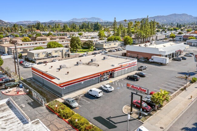
Property Detail
1080 E Main St
San Diego-Chula Vista-Carlsbad, CA
BLK 1 LOT 9 /EXC ST OP/ SLY 198.50 FT OF WLY 171.50 FT OF TR 000355
489-130-29
San Diego
Storesoffices
California
C-G
9
B and X Area of moderate flood hazard, usually the area between the limits of the 100-year and 500-year floods.
0.72 AC
2024
El Cajon
2025
San Diego
015701
NEARBY LISTINGS FOR SALE OR LEASE
DEMOGRAPHICS near 1080 E Main St
1 mile
3 mile
5 mile
2024 Total Population
46,137
151,301
312,874
2029 Population
46,288
151,294
312,587
Pop Growth 2024-2029
+ 0.33%
0.00%
(0.09%)
Average Age
37
39
40
2024 Total Households
15,247
50,567
108,996
HH Growth 2024-2029
+ 0.16%
(0.17%)
(0.25%)
Median Household Inc
$56,785
$81,243
$93,436
Avg Household Size
2.90
2.90
2.80
2024 Avg HH Vehicles
2.00
2.00
2.00
Median Home Value
$550,765
$729,690
$741,742
Median Year Built
1975
1973
1974
Nearby Places
Map Layers
Map Styles
 Street
 Aerial
Transit
 Traffic
 Biking
Places
Listings with unknown addresses are not visible on the map
- Restaurants
- Banks
- Shops
- Fitness
- Groceries
PUBLIC TRANSPORTATION
AIRPORT
San Diego International
Drive
Walk
Distance
San Diego International
26 min
17.6 mi
Freight Ports
Port of San Diego
Drive
Walk
Distance
Port of San Diego
24 min
16.5 mi
SALE & LEASE HISTORY
LISTING DATE
SALE/LEASE

Oct 19, 2023
For Sale
Nearby Properties
Address
Land Use
TOTAL SIZE
Lot Size
Zoning
Address
Land Use
TOTAL SIZE
Lot Size
Zoning
6.84 AC
M
Address
Land Use
TOTAL SIZE
Lot Size
Zoning
8.24 AC
RU
Address
Land Use
TOTAL SIZE
Lot Size
Zoning
7.46 AC
RM-2200
Address
Land Use
TOTAL SIZE
Lot Size
Zoning
5.90 AC
RM-2200
Address
Land Use
TOTAL SIZE
Lot Size
Zoning
39.17 AC
C-R
Address
Land Use
TOTAL SIZE
Lot Size
Zoning
8.82 AC
RM-2200
Address
Land Use
TOTAL SIZE
Lot Size
Zoning
6.12 AC
RM-2200
Address
Land Use
TOTAL SIZE
Lot Size
Zoning
5.83 AC
RM-2200
Address
Land Use
TOTAL SIZE
Lot Size
Zoning
9.38 AC
RU
Address
Land Use
TOTAL SIZE
Lot Size
Zoning
5.17 AC
R3
Address
Land Use
TOTAL SIZE
Lot Size
Zoning
5.77 AC
RM-2200
Address
Land Use
TOTAL SIZE
Lot Size
Zoning
64,900 SF
4.55 AC
RM-2200
Address
Land Use
TOTAL SIZE
Lot Size
Zoning
5.45 AC
R14
Address
Land Use
TOTAL SIZE
Lot Size
Zoning
4.39 AC
RM-2200
Address
Land Use
TOTAL SIZE
Lot Size
Zoning
3.80 AC
NC/R14
Address
Land Use
TOTAL SIZE
Lot Size
Zoning
4.75 AC
C-6
Address
Land Use
TOTAL SIZE
Lot Size
Zoning
4.69 AC
RU
Address
Land Use
TOTAL SIZE
Lot Size
Zoning
81,896 SF
3.74 AC
RM-2200
Address
Land Use
TOTAL SIZE
Lot Size
Zoning
95,024 SF
2.89 AC
RM-2200
Address
Land Use
TOTAL SIZE
Lot Size
Zoning
3.51 AC
RM-2200
Address
Land Use
TOTAL SIZE
Lot Size
Zoning
3.33 AC
R22
Address
Land Use
TOTAL SIZE
Lot Size
Zoning
77,930 SF
2.34 AC
O-P
Address
Land Use
TOTAL SIZE
Lot Size
Zoning
16.33 AC
C-R
Address
Land Use
TOTAL SIZE
Lot Size
Zoning
1.89 AC
C-R
Address
Land Use
TOTAL SIZE
Lot Size
Zoning
86,578 SF
4.26 AC
M
Address
Land Use
TOTAL SIZE
Lot Size
Zoning
8.81 AC
C-R
Address
Land Use
TOTAL SIZE
Lot Size
Zoning
82,752 SF
4.24 AC
RM-2200
Address
Land Use
TOTAL SIZE
Lot Size
Zoning
70,656 SF
2.67 AC
RM-2200
Address
Land Use
TOTAL SIZE
Lot Size
Zoning
4.76 AC
RM-1450
Address
Land Use
TOTAL SIZE
Lot Size
Zoning
74,882 SF
3.45 AC
RU
The World's #1 Commercial Real Estate Marketplace
Connect with us
© 2026 CoStar Group
The information above has been obtained from sources believed reliable. While we do not doubt its accuracy we have not verified it and make no guarantee, warranty or representation about it. It is your responsibility to independently confirm its accuracy and completeness. Any projections, opinions, assumptions, or estimates used are for example only and do not represent the current or future performance of the property. The value of this transaction to you depends on tax and other factors which should be evaluated by your tax, financial, and legal advisors. You and your advisors should conduct a careful, independent investigation of the property to determine to your satisfaction the suitability of the property for your needs.