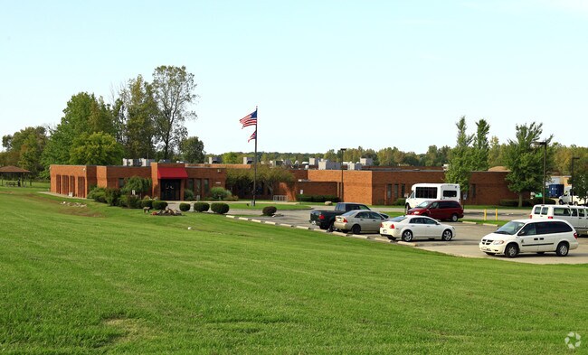
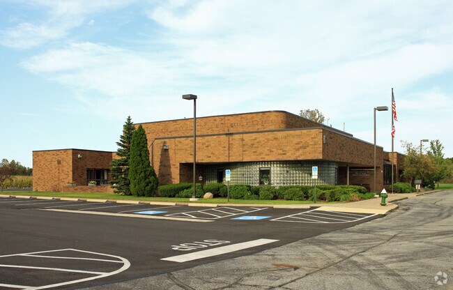
Property Record
1080 Infirmary Rd, Elyria, OH 44035

Save to a Folder
{{folder.Name}}
{{folder.ListingIds.length}} Properties
{{folder.ListingIds.length}} Property
Create a New Folder
Property Detail
1080 Infirmary Rd
10-00-002-000-023
JAIL-HEALTH DEPT TB CLINIC-DETENTION HOME MRDD-ADULT WORKSHOP
Commercialnec
LORAIN
B and X Area of moderate flood hazard, usually the area between the limits of the 100-year and 500-year floods.
Ohio
2025
160.58 AC
2024
Lorain/Avon Lake
070901
Cleveland
423,598 SF
Cleveland-Elyria, OH
NEARBY LISTINGS FOR SALE OR LEASE
DEMOGRAPHICS near 1080 Infirmary Rd
1 mile
3 mile
5 mile
2025 Total Population
2,156
39,142
74,042
2030 Population
2,218
40,042
75,782
Pop Growth 2025-2030
+ 2.88%
+ 2.30%
+ 2.35%
Average Age
37
41
43
2025 Total Households
867
16,522
31,627
HH Growth 2025-2030
+ 3.11%
+ 2.35%
+ 2.43%
Median Household Inc
$45,078
$52,543
$65,389
Avg Household Size
2.30
2.30
2.30
2025 Avg HH Vehicles
1.00
2.00
2.00
Median Home Value
$105,652
$148,008
$177,162
Median Year Built
1972
1962
1966
Nearby Places
Map Layers
Map Styles
 Street
 Aerial
Layers
 Traffic
 Biking
Places
Listings with unknown addresses are not visible on the map
- Restaurants
- Banks
- Shops
- Fitness
- Groceries
PUBLIC TRANSPORTATION
COMMUTER RAIL
Elyria Amtrak (Capitol Limited - Amtrak, Lake Shore Limited - Amtrak)
Drive
Walk
Distance
Elyria Amtrak (Capitol Limited - Amtrak, Lake Shore Limited - Amtrak)
6 min
2.8 mi
AIRPORT
Cleveland-Hopkins International
Drive
Walk
Distance
Cleveland-Hopkins International
31 min
21.0 mi
Freight Ports
Port of Toledo
Drive
Walk
Distance
Port of Toledo
110 min
90.9 mi
Nearby Properties
Address
Land Use
TOTAL SIZE
Lot Size
Zoning
Address
Land Use
TOTAL SIZE
Lot Size
Zoning
427,871 SF
6.24 AC
Address
Land Use
TOTAL SIZE
Lot Size
Zoning
351,623 SF
3.13 AC
Address
Land Use
TOTAL SIZE
Lot Size
Zoning
199,200 SF
1.77 AC
Address
Land Use
TOTAL SIZE
Lot Size
Zoning
264,274 SF
15.03 AC
Address
Land Use
TOTAL SIZE
Lot Size
Zoning
61,570 SF
0.20 AC
Address
Land Use
TOTAL SIZE
Lot Size
Zoning
150,180 SF
20.21 AC
Address
Land Use
TOTAL SIZE
Lot Size
Zoning
68,786 SF
33.55 AC
Address
Land Use
TOTAL SIZE
Lot Size
Zoning
Address
Land Use
TOTAL SIZE
Lot Size
Zoning
106,938 SF
1.12 AC
Address
Land Use
TOTAL SIZE
Lot Size
Zoning
32,784 SF
0.25 AC
Address
Land Use
TOTAL SIZE
Lot Size
Zoning
115,898 SF
8.67 AC
Address
Land Use
TOTAL SIZE
Lot Size
Zoning
158,510 SF
6.01 AC
Address
Land Use
TOTAL SIZE
Lot Size
Zoning
61,278 SF
8.25 AC
Address
Land Use
TOTAL SIZE
Lot Size
Zoning
57,634 SF
4.73 AC
Address
Land Use
TOTAL SIZE
Lot Size
Zoning
151,565 SF
0.11 AC
Address
Land Use
TOTAL SIZE
Lot Size
Zoning
39,249 SF
0.74 AC
Address
Land Use
TOTAL SIZE
Lot Size
Zoning
76,610 SF
2.49 AC
Address
Land Use
TOTAL SIZE
Lot Size
Zoning
141,945 SF
7.80 AC
Address
Land Use
TOTAL SIZE
Lot Size
Zoning
80,160 SF
4.67 AC
Address
Land Use
TOTAL SIZE
Lot Size
Zoning
52,685 SF
12.67 AC
Address
Land Use
TOTAL SIZE
Lot Size
Zoning
21,693 SF
1.27 AC
Address
Land Use
TOTAL SIZE
Lot Size
Zoning
42,095 SF
2.34 AC
Address
Land Use
TOTAL SIZE
Lot Size
Zoning
47,277 SF
54.68 AC
Address
Land Use
TOTAL SIZE
Lot Size
Zoning
174,353 SF
13.54 AC
Address
Land Use
TOTAL SIZE
Lot Size
Zoning
56,244 SF
0.17 AC
Address
Land Use
TOTAL SIZE
Lot Size
Zoning
108,512 SF
9.28 AC
Address
Land Use
TOTAL SIZE
Lot Size
Zoning
57,776 SF
4.18 AC
Address
Land Use
TOTAL SIZE
Lot Size
Zoning
25,122 SF
8 AC
Address
Land Use
TOTAL SIZE
Lot Size
Zoning
24,124 SF
3.82 AC
Address
Land Use
TOTAL SIZE
Lot Size
Zoning
117,369 SF
9.78 AC
The World's #1 Commercial Real Estate Marketplace
Connect with us
© 2026 CoStar Group
The information above has been obtained from sources believed reliable. While we do not doubt its accuracy we have not verified it and make no guarantee, warranty or representation about it. It is your responsibility to independently confirm its accuracy and completeness. Any projections, opinions, assumptions, or estimates used are for example only and do not represent the current or future performance of the property. The value of this transaction to you depends on tax and other factors which should be evaluated by your tax, financial, and legal advisors. You and your advisors should conduct a careful, independent investigation of the property to determine to your satisfaction the suitability of the property for your needs.