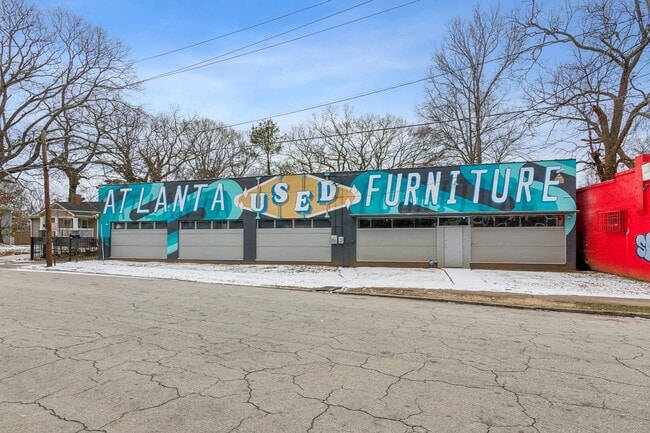
Property Record
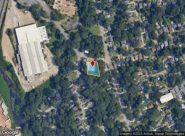
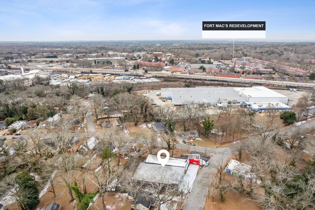
1080 Katherwood Dr Sw, Atlanta, GA 30310
NEARBY LISTINGS FOR SALE OR LEASE
Property Detail
1080 Katherwood Dr Sw
Atlanta-Sandy Springs-Roswell, GA
Bob Gottlieb
14-0121-0005-049-7
KA VACANT BLDG KA ? GARAGE/ AUTO SALES
Warehouse
Fulton
X
Georgia
13121C0358F
60
2024
0.40 AC
2025
Central Atlanta
006601
Atlanta
8,384 SF
DEMOGRAPHICS near 1080 Katherwood Dr Sw
1 Mile
3 Mile
5 Mile
2024 Total Population
8,930
102,461
277,497
2029 Population
9,336
107,044
290,143
Pop Growth 2024-2029
+ 4.55%
+ 4.47%
+ 4.56%
Average Age
39
38
37
2024 Total Households
3,834
42,043
115,723
HH Growth 2024-2029
+ 4.64%
+ 4.68%
+ 4.92%
Median Household Inc
$49,967
$40,452
$51,898
Avg Household Size
2.20
2.20
2.10
2024 Avg HH Vehicles
1.00
1.00
1.00
Median Home Value
$248,501
$256,363
$288,192
Median Year Built
1953
1964
1974
Nearby Places
Map Layers
Map Styles
 Street
 Aerial
- Restaurants
- Banks
- Shops
- Fitness
- Groceries
PUBLIC TRANSPORTATION
TRANSIT/SUBWAY
Oakland City (Gold Line - Metropolitan Atlanta Rapid Transit Authority (MARTA), Red Line - Metropolitan Atlanta Rapid Transit Authority (MARTA))
DRIVE
WALK
Distance
Oakland City (Gold Line - Metropolitan Atlanta Rapid Transit Authority (MARTA), Red Line - Metropolitan Atlanta Rapid Transit Authority (MARTA))
2 min
14 min
0.7 mi
Lakewood/Ft Mcpherson (Gold Line - Metropolitan Atlanta Rapid Transit Authority (MARTA), Red Line - Metropolitan Atlanta Rapid Transit Authority (MARTA))
DRIVE
WALK
Distance
Lakewood/Ft Mcpherson (Gold Line - Metropolitan Atlanta Rapid Transit Authority (MARTA), Red Line - Metropolitan Atlanta Rapid Transit Authority (MARTA))
3 min
19 min
0.9 mi
COMMUTER RAIL
Atlanta (Crescent - Amtrak)
DRIVE
WALK
Distance
Atlanta (Crescent - Amtrak)
15 min
8.8 mi
AIRPORT
Hartsfield - Jackson Atlanta International
DRIVE
WALK
Distance
Hartsfield - Jackson Atlanta International
14 min
6.9 mi
Freight Ports
Georgia Ports - Savannah
DRIVE
WALK
Distance
Georgia Ports - Savannah
277 min
246.2 mi
SALE & LEASE HISTORY
LISTING DATE
SALE/LEASE

Mar 12, 2025
For Sale
Jun 26, 2017
For Sale
Aug 03, 2017
For Sale
Nearby Properties
Address
Land Use
TOTAL SIZE
Lot Size
Zoning
Address
Land Use
TOTAL SIZE
Lot Size
Zoning
11.74 AC
I1
Address
Land Use
TOTAL SIZE
Lot Size
Zoning
7 AC
C3
Address
Land Use
TOTAL SIZE
Lot Size
Zoning
34 AC
OI
Address
Land Use
TOTAL SIZE
Lot Size
Zoning
498,515 SF
3.41 AC
C1
Address
Land Use
TOTAL SIZE
Lot Size
Zoning
469,344 SF
3.62 AC
C3
Address
Land Use
TOTAL SIZE
Lot Size
Zoning
330,125 SF
7.16 AC
I1
Address
Land Use
TOTAL SIZE
Lot Size
Zoning
541,508 SF
110.88 AC
I1
Address
Land Use
TOTAL SIZE
Lot Size
Zoning
1,128,762 SF
10.39 AC
I2
Address
Land Use
TOTAL SIZE
Lot Size
Zoning
857,294 SF
101.10 AC
I1
Address
Land Use
TOTAL SIZE
Lot Size
Zoning
293,935 SF
8.47 AC
I2
Address
Land Use
TOTAL SIZE
Lot Size
Zoning
3,411,710 SF
25.97 AC
RG3
Address
Land Use
TOTAL SIZE
Lot Size
Zoning
425,270 SF
201.84 AC
I1
Address
Land Use
TOTAL SIZE
Lot Size
Zoning
6.12 AC
OI
Address
Land Use
TOTAL SIZE
Lot Size
Zoning
191,217 SF
1.63 AC
RG3
Address
Land Use
TOTAL SIZE
Lot Size
Zoning
5.51 AC
OI
Address
Land Use
TOTAL SIZE
Lot Size
Zoning
396,330 SF
7.02 AC
RG3
Address
Land Use
TOTAL SIZE
Lot Size
Zoning
1,170,962 SF
38.32 AC
C3
Address
Land Use
TOTAL SIZE
Lot Size
Zoning
563,256 SF
22.69 AC
I1
Address
Land Use
TOTAL SIZE
Lot Size
Zoning
4.25 AC
R3
Address
Land Use
TOTAL SIZE
Lot Size
Zoning
164,664 SF
4.93 AC
I1
Address
Land Use
TOTAL SIZE
Lot Size
Zoning
18.43 AC
OI
Address
Land Use
TOTAL SIZE
Lot Size
Zoning
6,834,480 SF
9.85 AC
RG3
Address
Land Use
TOTAL SIZE
Lot Size
Zoning
689,523 SF
34.32 AC
I1
Address
Land Use
TOTAL SIZE
Lot Size
Zoning
1,352,250 SF
3.18 AC
C2
Address
Land Use
TOTAL SIZE
Lot Size
Zoning
427,450 SF
3 AC
C3
Address
Land Use
TOTAL SIZE
Lot Size
Zoning
35.10 AC
R1
Address
Land Use
TOTAL SIZE
Lot Size
Zoning
1,680 SF
2.45 AC
I2
Address
Land Use
TOTAL SIZE
Lot Size
Zoning
54.47 AC
OI
Address
Land Use
TOTAL SIZE
Lot Size
Zoning
154,200 SF
3.09 AC
I2
Address
Land Use
TOTAL SIZE
Lot Size
Zoning
94,134 SF
3.30 AC
I2
The World's #1 Commercial Real Estate Marketplace
Connect with us
© 2025 CoStar Group
The information above has been obtained from sources believed reliable. While we do not doubt its accuracy we have not verified it and make no guarantee, warranty or representation about it. It is your responsibility to independently confirm its accuracy and completeness. Any projections, opinions, assumptions, or estimates used are for example only and do not represent the current or future performance of the property. The value of this transaction to you depends on tax and other factors which should be evaluated by your tax, financial, and legal advisors. You and your advisors should conduct a careful, independent investigation of the property to determine to your satisfaction the suitability of the property for your needs.