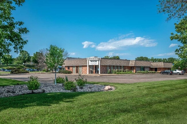
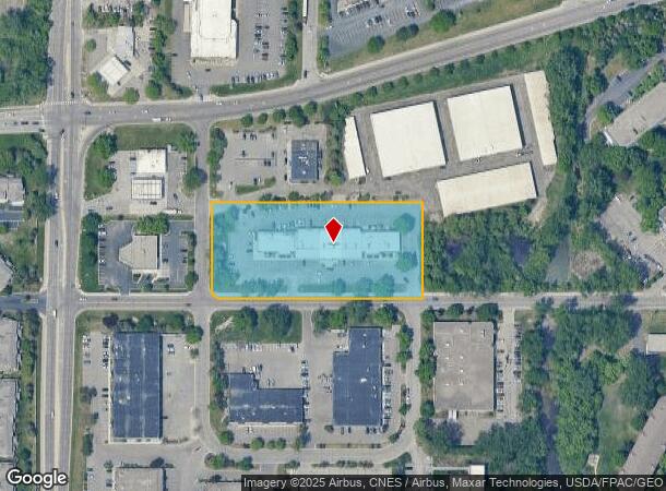
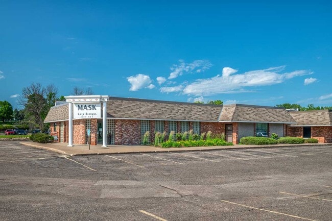
Property Record
10800 Greenbrier Rd, Hopkins, MN 55305
Current Lease Availabilities
NEARBY LISTINGS FOR SALE OR LEASE
Property Detail
10800 Greenbrier Rd
Minneapolis-St. Paul-Bloomington, MN-WI
Hedberg Minnetonka 2Nd Addn
12-117-22-33-0017
LOT 003 BLOCK 001 T HEDBERG MINNETONKA 2ND ADDN S 515X255X535X244
Commercialnec
Hennepin
X
Minnesota
27053C0333F
3
2024
3 AC
2024
Ridgedale
026404
Minneapolis/St Paul
21,924 SF
DEMOGRAPHICS near 10800 Greenbrier Rd
1 Mile
3 Mile
5 Mile
2024 Total Population
8,174
77,741
197,542
2029 Population
8,075
76,633
194,813
Pop Growth 2024-2029
(1.21%)
(1.43%)
(1.38%)
Average Age
44
41
42
2024 Total Households
4,051
34,945
89,192
HH Growth 2024-2029
(1.60%)
(1.57%)
(1.42%)
Median Household Inc
$87,286
$89,916
$96,400
Avg Household Size
1.90
2.10
2.10
2024 Avg HH Vehicles
2.00
2.00
2.00
Median Home Value
$352,736
$364,962
$393,613
Median Year Built
1981
1972
1973
Nearby Places
- Restaurants
- Banks
- Shops
- Fitness
- Groceries
PUBLIC TRANSPORTATION
COMMUTER RAIL
Target Field Station (Northstar Corridor - Northstar Commuter Rail)
DRIVE
WALK
Distance
Target Field Station (Northstar Corridor - Northstar Commuter Rail)
12 min
9.1 mi
AIRPORT
Minneapolis-St Paul International/Wold-Chamberlain
DRIVE
WALK
Distance
Minneapolis-St Paul International/Wold-Chamberlain
22 min
17.8 mi
Freight Ports
Port of Shreveport
DRIVE
WALK
Distance
Port of Shreveport
1 min
870.4 mi
Nearby Properties
Address
Land Use
TOTAL SIZE
Lot Size
Zoning
Address
Land Use
TOTAL SIZE
Lot Size
Zoning
18.27 AC
Address
Land Use
TOTAL SIZE
Lot Size
Zoning
0.90 AC
Address
Land Use
TOTAL SIZE
Lot Size
Zoning
20,710 SF
7.69 AC
PID
Address
Land Use
TOTAL SIZE
Lot Size
Zoning
20,710 SF
7.69 AC
PID
Address
Land Use
TOTAL SIZE
Lot Size
Zoning
6.47 AC
Address
Land Use
TOTAL SIZE
Lot Size
Zoning
19.75 AC
Address
Land Use
TOTAL SIZE
Lot Size
Zoning
224,581 SF
13.72 AC
PUD
Address
Land Use
TOTAL SIZE
Lot Size
Zoning
19.46 AC
PUD
Address
Land Use
TOTAL SIZE
Lot Size
Zoning
202,718 SF
14.37 AC
PID
Address
Land Use
TOTAL SIZE
Lot Size
Zoning
Address
Land Use
TOTAL SIZE
Lot Size
Zoning
196,498 SF
13.13 AC
PID
Address
Land Use
TOTAL SIZE
Lot Size
Zoning
38.20 AC
Address
Land Use
TOTAL SIZE
Lot Size
Zoning
11.93 AC
PID
Address
Land Use
TOTAL SIZE
Lot Size
Zoning
2.58 AC
Address
Land Use
TOTAL SIZE
Lot Size
Zoning
2.38 AC
Address
Land Use
TOTAL SIZE
Lot Size
Zoning
Address
Land Use
TOTAL SIZE
Lot Size
Zoning
171,900 SF
39.17 AC
B1
Address
Land Use
TOTAL SIZE
Lot Size
Zoning
127,084 SF
17.21 AC
Address
Land Use
TOTAL SIZE
Lot Size
Zoning
244,941 SF
5.24 AC
Address
Land Use
TOTAL SIZE
Lot Size
Zoning
Address
Land Use
TOTAL SIZE
Lot Size
Zoning
13.80 AC
Address
Land Use
TOTAL SIZE
Lot Size
Zoning
4.34 AC
Address
Land Use
TOTAL SIZE
Lot Size
Zoning
94,155 SF
2.06 AC
PUD
Address
Land Use
TOTAL SIZE
Lot Size
Zoning
1.55 AC
Address
Land Use
TOTAL SIZE
Lot Size
Zoning
10.57 AC
PID
Address
Land Use
TOTAL SIZE
Lot Size
Zoning
7.06 AC
Address
Land Use
TOTAL SIZE
Lot Size
Zoning
12.06 AC
PID
Address
Land Use
TOTAL SIZE
Lot Size
Zoning
2.69 AC
Address
Land Use
TOTAL SIZE
Lot Size
Zoning
255,931 SF
3.79 AC
Address
Land Use
TOTAL SIZE
Lot Size
Zoning
7.32 AC
The World's #1 Commercial Real Estate Marketplace
Connect with us
© 2025 CoStar Group
The information above has been obtained from sources believed reliable. While we do not doubt its accuracy we have not verified it and make no guarantee, warranty or representation about it. It is your responsibility to independently confirm its accuracy and completeness. Any projections, opinions, assumptions, or estimates used are for example only and do not represent the current or future performance of the property. The value of this transaction to you depends on tax and other factors which should be evaluated by your tax, financial, and legal advisors. You and your advisors should conduct a careful, independent investigation of the property to determine to your satisfaction the suitability of the property for your needs.