Property Record
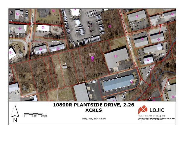
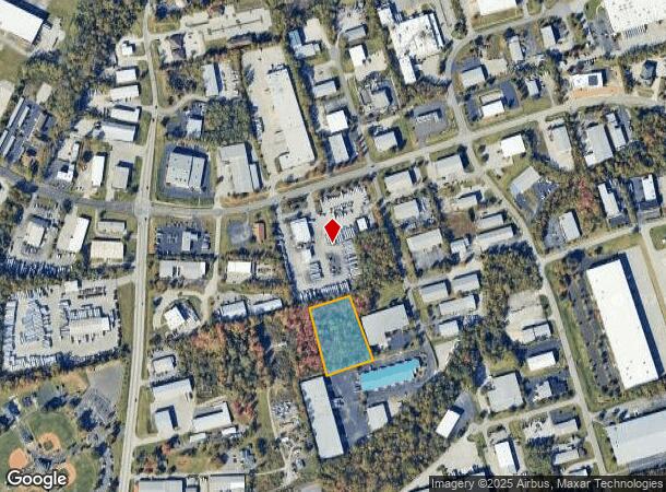
10800 Plantside Dr, Louisville, KY 40299
This Property Is For Sale
NEARBY LISTINGS FOR SALE OR LEASE
Property Detail
10800 Plantside Dr
Louisville-Jefferson County, KY-IN
Midway Farm
003900990000
2.16 AC +/- R PLANTSIDE DR
Industrialacreage
Jefferson
X
Kentucky
21111C0064F
2.16 AC
2024
Southeast
2024
Louisville
011116
DEMOGRAPHICS near 10800 Plantside Dr
1 Mile
3 Mile
5 Mile
2024 Total Population
2,164
65,191
161,980
2029 Population
2,112
63,967
159,225
Pop Growth 2024-2029
(2.40%)
(1.88%)
(1.70%)
Average Age
41
42
41
2024 Total Households
932
27,770
69,277
HH Growth 2024-2029
(2.47%)
(1.89%)
(1.67%)
Median Household Inc
$76,474
$82,152
$79,221
Avg Household Size
2.20
2.30
2.30
2024 Avg HH Vehicles
2.00
2.00
2.00
Median Home Value
$212,313
$267,622
$260,582
Median Year Built
1969
1984
1981
Nearby Places
- Restaurants
- Banks
- Shops
- Fitness
- Groceries
PUBLIC TRANSPORTATION
AIRPORT
Louisville Muhammad Ali International
DRIVE
WALK
Distance
Louisville Muhammad Ali International
30 min
15.1 mi
Freight Ports
Port of Toledo
DRIVE
WALK
Distance
Port of Toledo
356 min
302.2 mi
Nearby Properties
Address
Land Use
TOTAL SIZE
Lot Size
Zoning
Address
Land Use
TOTAL SIZE
Lot Size
Zoning
115.43 AC
R4-RESIDEN
Address
Land Use
TOTAL SIZE
Lot Size
Zoning
2,776 SF
34.17 AC
R4-RESIDEN
Address
Land Use
TOTAL SIZE
Lot Size
Zoning
1,194 SF
38.74 AC
R4-RESIDEN
Address
Land Use
TOTAL SIZE
Lot Size
Zoning
Address
Land Use
TOTAL SIZE
Lot Size
Zoning
1,334 SF
24.71 AC
R4-RESIDEN
Address
Land Use
TOTAL SIZE
Lot Size
Zoning
8.47 AC
R1-RESIDEN
Address
Land Use
TOTAL SIZE
Lot Size
Zoning
45.92 AC
Address
Land Use
TOTAL SIZE
Lot Size
Zoning
2,140 SF
18.35 AC
R4-RESIDEN
Address
Land Use
TOTAL SIZE
Lot Size
Zoning
19.57 AC
Address
Land Use
TOTAL SIZE
Lot Size
Zoning
18,394 SF
22.09 AC
C1-COMMERC
Address
Land Use
TOTAL SIZE
Lot Size
Zoning
202,557 SF
6.06 AC
C2-COMMERC
Address
Land Use
TOTAL SIZE
Lot Size
Zoning
19,568 SF
24.23 AC
R7-RESIDEN
Address
Land Use
TOTAL SIZE
Lot Size
Zoning
175,971 SF
18.54 AC
PEC-PLANNE
Address
Land Use
TOTAL SIZE
Lot Size
Zoning
10,026 SF
13.45 AC
R6-RESIDEN
Address
Land Use
TOTAL SIZE
Lot Size
Zoning
18,784 SF
16.80 AC
R6-RESIDEN
Address
Land Use
TOTAL SIZE
Lot Size
Zoning
9,844 SF
15.11 AC
R6-RESIDEN
Address
Land Use
TOTAL SIZE
Lot Size
Zoning
910 SF
9.77 AC
R6-RESIDEN
Address
Land Use
TOTAL SIZE
Lot Size
Zoning
28.91 AC
R4-RESIDEN
Address
Land Use
TOTAL SIZE
Lot Size
Zoning
115,168 SF
8.59 AC
C1-COMMERC
Address
Land Use
TOTAL SIZE
Lot Size
Zoning
31,968 SF
15.34 AC
R4-RESIDEN
Address
Land Use
TOTAL SIZE
Lot Size
Zoning
4,267 SF
10.13 AC
R6-RESIDEN
Address
Land Use
TOTAL SIZE
Lot Size
Zoning
Address
Land Use
TOTAL SIZE
Lot Size
Zoning
9,560 SF
20.31 AC
C1-COMMERC
Address
Land Use
TOTAL SIZE
Lot Size
Zoning
159,847 SF
5.23 AC
PEC-PLANNE
Address
Land Use
TOTAL SIZE
Lot Size
Zoning
110,088 SF
8.69 AC
PEC-PLANNE
Address
Land Use
TOTAL SIZE
Lot Size
Zoning
10,358 SF
17.01 AC
R6-RESIDEN
Address
Land Use
TOTAL SIZE
Lot Size
Zoning
30.45 AC
Address
Land Use
TOTAL SIZE
Lot Size
Zoning
19.91 AC
Address
Land Use
TOTAL SIZE
Lot Size
Zoning
48,000 SF
29.85 AC
PEC-PLANNE
Address
Land Use
TOTAL SIZE
Lot Size
Zoning
13,810 SF
12.69 AC
R6-RESIDEN
The World's #1 Commercial Real Estate Marketplace
Connect with us
© 2025 CoStar Group
The information above has been obtained from sources believed reliable. While we do not doubt its accuracy we have not verified it and make no guarantee, warranty or representation about it. It is your responsibility to independently confirm its accuracy and completeness. Any projections, opinions, assumptions, or estimates used are for example only and do not represent the current or future performance of the property. The value of this transaction to you depends on tax and other factors which should be evaluated by your tax, financial, and legal advisors. You and your advisors should conduct a careful, independent investigation of the property to determine to your satisfaction the suitability of the property for your needs.