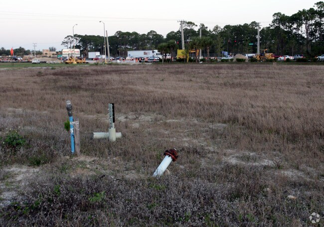
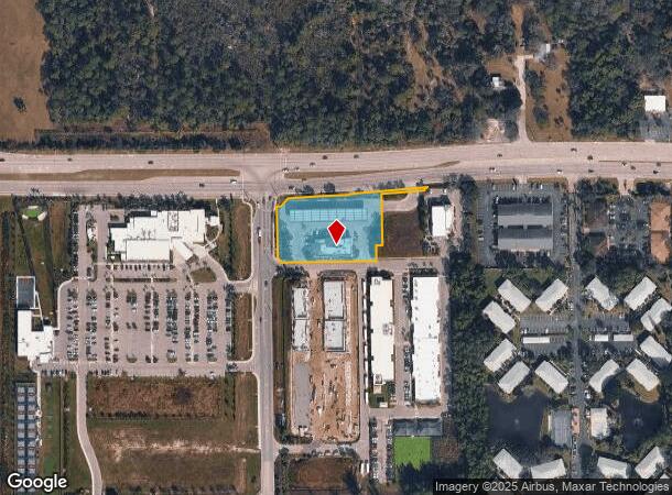
Property Record
10801 Furlong St, Bonita Springs, FL 34135

NEARBY LISTINGS FOR SALE OR LEASE
Property Detail
10801 Furlong St
02-48-25-B2-02700.0001
Bonita Bch Rd Corridor
Supermarket
GREYHOUND SQUARE LAND CONDO AS DESC IN INST # 2010000166241 UNIT 1 LESS PT DESC IN 2012000126981
X
Lee
12071C0659G
Florida
2024
1.56 AC
2025
Bonita Springs
050502
Southwest Florida
5,928 SF
Cape Coral-Fort Myers, FL
DEMOGRAPHICS near 10801 Furlong St
1 Mile
3 Mile
5 Mile
2024 Total Population
8,391
52,508
109,161
2029 Population
10,016
62,350
128,538
Pop Growth 2024-2029
+ 19.37%
+ 18.74%
+ 17.75%
Average Age
41
51
54
2024 Total Households
3,184
23,259
50,722
HH Growth 2024-2029
+ 18.94%
+ 18.37%
+ 17.53%
Median Household Inc
$65,267
$74,486
$84,083
Avg Household Size
2.50
2.10
2.10
2024 Avg HH Vehicles
2.00
2.00
2.00
Median Home Value
$291,837
$360,186
$425,913
Median Year Built
1991
1996
1997
Nearby Places
Map Layers
Map Styles
 Street
 Aerial
- Restaurants
- Banks
- Shops
- Fitness
- Groceries
PUBLIC TRANSPORTATION
AIRPORT
Southwest Florida International
DRIVE
WALK
Distance
Southwest Florida International
28 min
20.3 mi
Nearby Properties
Address
Land Use
TOTAL SIZE
Lot Size
Zoning
Address
Land Use
TOTAL SIZE
Lot Size
Zoning
993,493 SF
86.10 AC
PUD
Address
Land Use
TOTAL SIZE
Lot Size
Zoning
313,544 SF
60 AC
A
Address
Land Use
TOTAL SIZE
Lot Size
Zoning
325,993 SF
35.92 AC
A
Address
Land Use
TOTAL SIZE
Lot Size
Zoning
406,601 SF
19.88 AC
RPD
Address
Land Use
TOTAL SIZE
Lot Size
Zoning
311,416 SF
17.06 AC
Address
Land Use
TOTAL SIZE
Lot Size
Zoning
339,402 SF
21.19 AC
CPD
Address
Land Use
TOTAL SIZE
Lot Size
Zoning
331,056 SF
8 AC
CPD
Address
Land Use
TOTAL SIZE
Lot Size
Zoning
252,506 SF
36.27 AC
PUD
Address
Land Use
TOTAL SIZE
Lot Size
Zoning
221,244 SF
65.55 AC
MPD
Address
Land Use
TOTAL SIZE
Lot Size
Zoning
435,724 SF
64.61 AC
PUD
Address
Land Use
TOTAL SIZE
Lot Size
Zoning
227,264 SF
8.72 AC
A
Address
Land Use
TOTAL SIZE
Lot Size
Zoning
366,884 SF
30.65 AC
RM-2
Address
Land Use
TOTAL SIZE
Lot Size
Zoning
128,681 SF
49.55 AC
A
Address
Land Use
TOTAL SIZE
Lot Size
Zoning
253,108 SF
32.47 AC
PUD
Address
Land Use
TOTAL SIZE
Lot Size
Zoning
230,920 SF
7.80 AC
C-4
Address
Land Use
TOTAL SIZE
Lot Size
Zoning
286,416 SF
28.78 AC
CG
Address
Land Use
TOTAL SIZE
Lot Size
Zoning
214,836 SF
24.50 AC
CPD
Address
Land Use
TOTAL SIZE
Lot Size
Zoning
464,234 SF
22.53 AC
CPD
Address
Land Use
TOTAL SIZE
Lot Size
Zoning
106,929 SF
23.05 AC
A
Address
Land Use
TOTAL SIZE
Lot Size
Zoning
182,802 SF
18.08 AC
CC
Address
Land Use
TOTAL SIZE
Lot Size
Zoning
63,235 SF
22.36 AC
PUD
Address
Land Use
TOTAL SIZE
Lot Size
Zoning
145,881 SF
142.48 AC
PUD
Address
Land Use
TOTAL SIZE
Lot Size
Zoning
133,571 SF
18.86 AC
C-4
Address
Land Use
TOTAL SIZE
Lot Size
Zoning
144,993 SF
8.73 AC
PUD
Address
Land Use
TOTAL SIZE
Lot Size
Zoning
63,768 SF
8.73 AC
Address
Land Use
TOTAL SIZE
Lot Size
Zoning
52,150 SF
136.13 AC
PUD
Address
Land Use
TOTAL SIZE
Lot Size
Zoning
1.50 AC
RPD
Address
Land Use
TOTAL SIZE
Lot Size
Zoning
96,875 SF
5.52 AC
I
Address
Land Use
TOTAL SIZE
Lot Size
Zoning
111,478 SF
15.76 AC
AG-2
Address
Land Use
TOTAL SIZE
Lot Size
Zoning
117,766 SF
4.48 AC
RPD
The World's #1 Commercial Real Estate Marketplace
Connect with us
© 2025 CoStar Group
The information above has been obtained from sources believed reliable. While we do not doubt its accuracy we have not verified it and make no guarantee, warranty or representation about it. It is your responsibility to independently confirm its accuracy and completeness. Any projections, opinions, assumptions, or estimates used are for example only and do not represent the current or future performance of the property. The value of this transaction to you depends on tax and other factors which should be evaluated by your tax, financial, and legal advisors. You and your advisors should conduct a careful, independent investigation of the property to determine to your satisfaction the suitability of the property for your needs.