Property Record
10801 Pleasant Valley Rd, Cedarburg, WI 53012


NEARBY LISTINGS FOR SALE OR LEASE
-
-
View all Cedarburg listings for sale on LoopNet.com
Property Detail
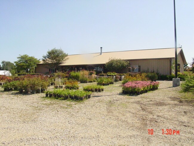
10801 Pleasant Valley Rd
Milwaukee-Waukesha-West Allis, WI
1144583 PART NE NE 3.18 ACS COMM 461 FT W & 33 FT S OF NE COR BEING #3489 CSM LOT 1 DOC 0795172 SEC 7 T 10 R 21
30070100600
Ozaukee
Commercialnec
Wisconsin
X
1
55089C0156G
3.03 AC
2024
North Ozaukee
2024
Milwaukee/Madison
650300
DEMOGRAPHICS near 10801 Pleasant Valley Rd
1 Mile
3 Mile
5 Mile
2024 Total Population
483
4,119
22,646
2029 Population
506
4,268
23,236
Pop Growth 2024-2029
+ 4.76%
+ 3.62%
+ 2.61%
Average Age
44
44
43
2024 Total Households
180
1,497
8,734
HH Growth 2024-2029
+ 4.44%
+ 3.54%
+ 2.53%
Median Household Inc
$91,249
$111,040
$91,813
Avg Household Size
2.70
2.70
2.50
2024 Avg HH Vehicles
2.00
2.00
2.00
Median Home Value
$381,745
$384,893
$338,701
Median Year Built
1978
1978
1975
Nearby Places
Map Layers
Map Styles
 Street
 Aerial
- Restaurants
- Banks
- Shops
- Fitness
- Groceries
PUBLIC TRANSPORTATION
AIRPORT
General Mitchell International
DRIVE
WALK
Distance
General Mitchell International
50 min
34.3 mi
Nearby Properties
Address
Land Use
TOTAL SIZE
Lot Size
Zoning
Address
Land Use
TOTAL SIZE
Lot Size
Zoning
Address
Land Use
TOTAL SIZE
Lot Size
Zoning
Address
Land Use
TOTAL SIZE
Lot Size
Zoning
Address
Land Use
TOTAL SIZE
Lot Size
Zoning
Address
Land Use
TOTAL SIZE
Lot Size
Zoning
Address
Land Use
TOTAL SIZE
Lot Size
Zoning
10.94 AC
Address
Land Use
TOTAL SIZE
Lot Size
Zoning
Address
Land Use
TOTAL SIZE
Lot Size
Zoning
Address
Land Use
TOTAL SIZE
Lot Size
Zoning
Address
Land Use
TOTAL SIZE
Lot Size
Zoning
Address
Land Use
TOTAL SIZE
Lot Size
Zoning
Address
Land Use
TOTAL SIZE
Lot Size
Zoning
Address
Land Use
TOTAL SIZE
Lot Size
Zoning
Address
Land Use
TOTAL SIZE
Lot Size
Zoning
Address
Land Use
TOTAL SIZE
Lot Size
Zoning
Address
Land Use
TOTAL SIZE
Lot Size
Zoning
21,600 SF
7.76 AC
Address
Land Use
TOTAL SIZE
Lot Size
Zoning
Address
Land Use
TOTAL SIZE
Lot Size
Zoning
Address
Land Use
TOTAL SIZE
Lot Size
Zoning
2.51 AC
Address
Land Use
TOTAL SIZE
Lot Size
Zoning
Address
Land Use
TOTAL SIZE
Lot Size
Zoning
21.07 AC
Address
Land Use
TOTAL SIZE
Lot Size
Zoning
4,408 SF
0.83 AC
Address
Land Use
TOTAL SIZE
Lot Size
Zoning
14.18 AC
Address
Land Use
TOTAL SIZE
Lot Size
Zoning
39.30 AC
Address
Land Use
TOTAL SIZE
Lot Size
Zoning
Address
Land Use
TOTAL SIZE
Lot Size
Zoning
Address
Land Use
TOTAL SIZE
Lot Size
Zoning
Address
Land Use
TOTAL SIZE
Lot Size
Zoning
12.89 AC
Address
Land Use
TOTAL SIZE
Lot Size
Zoning
12.23 AC
Address
Land Use
TOTAL SIZE
Lot Size
Zoning
11.60 AC
The World's #1 Commercial Real Estate Marketplace
Connect with us
© 2026 CoStar Group
The information above has been obtained from sources believed reliable. While we do not doubt its accuracy we have not verified it and make no guarantee, warranty or representation about it. It is your responsibility to independently confirm its accuracy and completeness. Any projections, opinions, assumptions, or estimates used are for example only and do not represent the current or future performance of the property. The value of this transaction to you depends on tax and other factors which should be evaluated by your tax, financial, and legal advisors. You and your advisors should conduct a careful, independent investigation of the property to determine to your satisfaction the suitability of the property for your needs.