Property Record
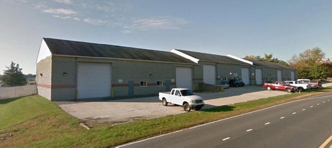
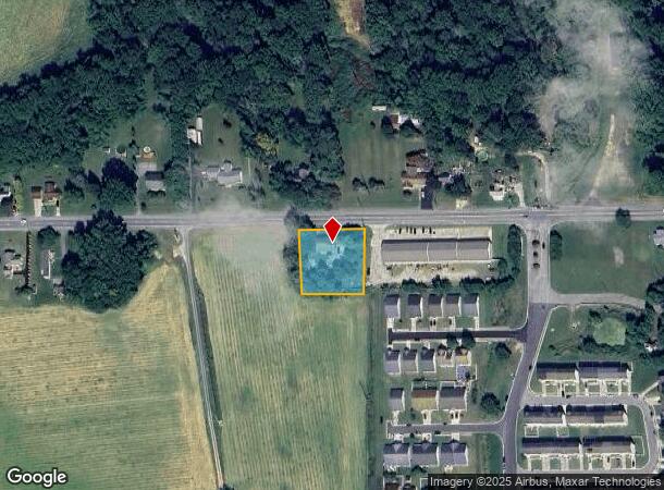
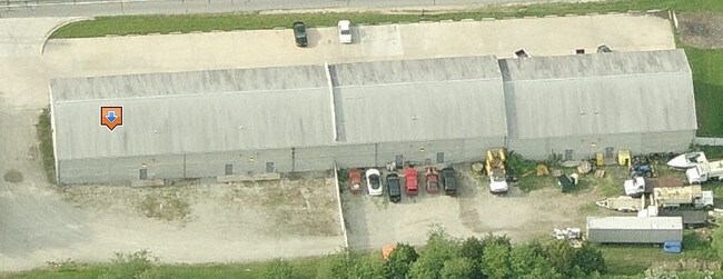
10770 Westville Rd, Camden Wyoming, DE 19934
Current Lease Availabilities
NEARBY LISTINGS FOR SALE OR LEASE
-
-
View all Camden Wyoming listings for lease on LoopNet.com
Property Detail
10770 Westville Rd
Dover, DE
Kent
7-00-09300-02-2300-000
Delaware
Sfr
0.71 AC
X
Kent County
10001C0227J
Philadelphia
1,952 SF
DEMOGRAPHICS near 10770 Westville Rd
1 Mile
3 Mile
5 Mile
2024 Total Population
2,605
29,689
79,847
2029 Population
2,813
31,846
85,590
Pop Growth 2024-2029
+ 7.98%
+ 7.27%
+ 7.19%
Average Age
40
40
39
2024 Total Households
1,006
11,204
30,170
HH Growth 2024-2029
+ 8.15%
+ 7.48%
+ 7.46%
Median Household Inc
$66,280
$66,601
$64,109
Avg Household Size
2.60
2.60
2.50
2024 Avg HH Vehicles
2.00
2.00
2.00
Median Home Value
$280,630
$274,567
$278,936
Median Year Built
1990
1989
1989
Nearby Places
Map Layers
Map Styles
 Street
 Aerial
- Restaurants
- Banks
- Shops
- Fitness
- Groceries
Nearby Properties
Address
Land Use
TOTAL SIZE
Lot Size
Zoning
Address
Land Use
TOTAL SIZE
Lot Size
Zoning
308,750 SF
102.10 AC
R10
Address
Land Use
TOTAL SIZE
Lot Size
Zoning
494,672 SF
35.80 AC
NA
Address
Land Use
TOTAL SIZE
Lot Size
Zoning
95,706 SF
22.94 AC
R10
Address
Land Use
TOTAL SIZE
Lot Size
Zoning
93,186 SF
89.27 AC
IPM
Address
Land Use
TOTAL SIZE
Lot Size
Zoning
228,076 SF
15.50 AC
BG
Address
Land Use
TOTAL SIZE
Lot Size
Zoning
108,450 SF
11 AC
RM
Address
Land Use
TOTAL SIZE
Lot Size
Zoning
109,262 SF
15.03 AC
NA
Address
Land Use
TOTAL SIZE
Lot Size
Zoning
188,100 SF
9.70 AC
RG2
Address
Land Use
TOTAL SIZE
Lot Size
Zoning
136,440 SF
6.60 AC
RM1
Address
Land Use
TOTAL SIZE
Lot Size
Zoning
52,250 SF
8.50 AC
RG2
Address
Land Use
TOTAL SIZE
Lot Size
Zoning
5,529 SF
83.30 AC
NA
Address
Land Use
TOTAL SIZE
Lot Size
Zoning
190,988 SF
19.90 AC
NA
Address
Land Use
TOTAL SIZE
Lot Size
Zoning
37,779 SF
5.90 AC
RM1
Address
Land Use
TOTAL SIZE
Lot Size
Zoning
62,572 SF
53 AC
RS1
Address
Land Use
TOTAL SIZE
Lot Size
Zoning
Address
Land Use
TOTAL SIZE
Lot Size
Zoning
91,738 SF
22.17 AC
R1
Address
Land Use
TOTAL SIZE
Lot Size
Zoning
125,394 SF
19.10 AC
RS1
Address
Land Use
TOTAL SIZE
Lot Size
Zoning
19,147 SF
189.40 AC
AC
Address
Land Use
TOTAL SIZE
Lot Size
Zoning
70,500 SF
7 AC
RM2
Address
Land Use
TOTAL SIZE
Lot Size
Zoning
93,452 SF
5 AC
IPM
Address
Land Use
TOTAL SIZE
Lot Size
Zoning
34,020 SF
20.46 AC
BN
Address
Land Use
TOTAL SIZE
Lot Size
Zoning
111,121 SF
8.40 AC
IPM
Address
Land Use
TOTAL SIZE
Lot Size
Zoning
94,050 SF
5.60 AC
RG2
Address
Land Use
TOTAL SIZE
Lot Size
Zoning
58,026 SF
17 AC
NA
Address
Land Use
TOTAL SIZE
Lot Size
Zoning
41,588 SF
19.64 AC
AP/10
Address
Land Use
TOTAL SIZE
Lot Size
Zoning
27,804 SF
5.73 AC
R10
Address
Land Use
TOTAL SIZE
Lot Size
Zoning
60,878 SF
6.80 AC
BG
Address
Land Use
TOTAL SIZE
Lot Size
Zoning
54,621 SF
20 AC
IO
Address
Land Use
TOTAL SIZE
Lot Size
Zoning
75,742 SF
6.10 AC
IPM
Address
Land Use
TOTAL SIZE
Lot Size
Zoning
23,924 SF
17.70 AC
RS1
The World's #1 Commercial Real Estate Marketplace
Connect with us
© 2025 CoStar Group
The information above has been obtained from sources believed reliable. While we do not doubt its accuracy we have not verified it and make no guarantee, warranty or representation about it. It is your responsibility to independently confirm its accuracy and completeness. Any projections, opinions, assumptions, or estimates used are for example only and do not represent the current or future performance of the property. The value of this transaction to you depends on tax and other factors which should be evaluated by your tax, financial, and legal advisors. You and your advisors should conduct a careful, independent investigation of the property to determine to your satisfaction the suitability of the property for your needs.