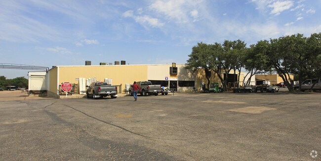
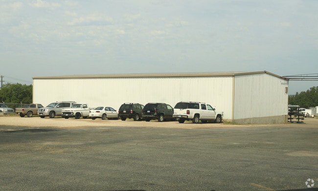
Property Record
10806 N Ranch Rd 620 Rd, Austin, TX 78726

Current Lease Availabilities
Property Detail
10806 N Ranch Rd 620 Rd
440978
ABS 478 SUR 455 LIVINGSTON A E ACR 16.38
Industrialgeneral
TRAVIS
B and X Area of moderate flood hazard, usually the area between the limits of the 100-year and 500-year floods.
Texas
2025
16.38 AC
2025
Far Northwest
034600
Austin
76,029 SF
Austin-Round Rock-San Marcos, TX
NEARBY LISTINGS FOR SALE OR LEASE
DEMOGRAPHICS near 10806 N Ranch Rd 620 Rd
1 mile
3 mile
5 mile
2025 Total Population
7,283
72,758
173,512
2030 Population
7,694
78,997
190,782
Pop Growth 2025-2030
+ 5.64%
+ 8.58%
+ 9.95%
Average Age
39
39
38
2025 Total Households
2,834
29,251
70,915
HH Growth 2025-2030
+ 6.14%
+ 9.57%
+ 10.79%
Median Household Inc
$116,872
$116,360
$113,033
Avg Household Size
2.50
2.50
2.40
2025 Avg HH Vehicles
2.00
2.00
2.00
Median Home Value
$633,550
$596,345
$606,607
Median Year Built
1998
1998
1999
Nearby Places
Map Layers
Map Styles
 Street
 Aerial
Layers
 Traffic
 Biking
Places
Listings with unknown addresses are not visible on the map
- Restaurants
- Banks
- Shops
- Fitness
- Groceries
PUBLIC TRANSPORTATION
AIRPORT
Austin-Bergstrom International
Drive
Walk
Distance
Austin-Bergstrom International
43 min
29.1 mi
Freight Ports
Calhoun Port
Drive
Walk
Distance
Calhoun Port
208 min
172.6 mi
Nearby Properties
Address
Land Use
TOTAL SIZE
Lot Size
Zoning
Address
Land Use
TOTAL SIZE
Lot Size
Zoning
676,868 SF
13.54 AC
3-PD
Address
Land Use
TOTAL SIZE
Lot Size
Zoning
557,037 SF
29.48 AC
Address
Land Use
TOTAL SIZE
Lot Size
Zoning
423,057 SF
21.90 AC
4-GRMUCO
Address
Land Use
TOTAL SIZE
Lot Size
Zoning
369,192 SF
78.87 AC
Address
Land Use
TOTAL SIZE
Lot Size
Zoning
411,288 SF
27.68 AC
Address
Land Use
TOTAL SIZE
Lot Size
Zoning
576,996 SF
38.77 AC
Address
Land Use
TOTAL SIZE
Lot Size
Zoning
610,326 SF
43.30 AC
Address
Land Use
TOTAL SIZE
Lot Size
Zoning
557,037 SF
32.48 AC
Address
Land Use
TOTAL SIZE
Lot Size
Zoning
687,401 SF
20.47 AC
Address
Land Use
TOTAL SIZE
Lot Size
Zoning
468,870 SF
22 AC
4-GRMUCO
Address
Land Use
TOTAL SIZE
Lot Size
Zoning
388,673 SF
30.98 AC
Address
Land Use
TOTAL SIZE
Lot Size
Zoning
306,900 SF
34.50 AC
Address
Land Use
TOTAL SIZE
Lot Size
Zoning
320,454 SF
19.56 AC
Address
Land Use
TOTAL SIZE
Lot Size
Zoning
338,434 SF
40.57 AC
3-PD
Address
Land Use
TOTAL SIZE
Lot Size
Zoning
365,955 SF
22.84 AC
Address
Land Use
TOTAL SIZE
Lot Size
Zoning
172,975 SF
33.88 AC
Address
Land Use
TOTAL SIZE
Lot Size
Zoning
395,632 SF
20.25 AC
Address
Land Use
TOTAL SIZE
Lot Size
Zoning
306,445 SF
23.59 AC
Address
Land Use
TOTAL SIZE
Lot Size
Zoning
349,200 SF
28.91 AC
Address
Land Use
TOTAL SIZE
Lot Size
Zoning
275,271 SF
14.14 AC
Address
Land Use
TOTAL SIZE
Lot Size
Zoning
264,559 SF
12.23 AC
Address
Land Use
TOTAL SIZE
Lot Size
Zoning
474,472 SF
9.22 AC
Address
Land Use
TOTAL SIZE
Lot Size
Zoning
289,330 SF
25.35 AC
Address
Land Use
TOTAL SIZE
Lot Size
Zoning
356,885 SF
20.70 AC
Address
Land Use
TOTAL SIZE
Lot Size
Zoning
299,893 SF
23.10 AC
Address
Land Use
TOTAL SIZE
Lot Size
Zoning
341,389 SF
12.19 AC
4-GRMUCO
Address
Land Use
TOTAL SIZE
Lot Size
Zoning
320,712 SF
35.56 AC
Address
Land Use
TOTAL SIZE
Lot Size
Zoning
285,768 SF
23.77 AC
Address
Land Use
TOTAL SIZE
Lot Size
Zoning
253,387 SF
12.87 AC
4-GRMUCO
Address
Land Use
TOTAL SIZE
Lot Size
Zoning
262,480 SF
27.52 AC
The World's #1 Commercial Real Estate Marketplace
Connect with us
© 2026 CoStar Group
The information above has been obtained from sources believed reliable. While we do not doubt its accuracy we have not verified it and make no guarantee, warranty or representation about it. It is your responsibility to independently confirm its accuracy and completeness. Any projections, opinions, assumptions, or estimates used are for example only and do not represent the current or future performance of the property. The value of this transaction to you depends on tax and other factors which should be evaluated by your tax, financial, and legal advisors. You and your advisors should conduct a careful, independent investigation of the property to determine to your satisfaction the suitability of the property for your needs.