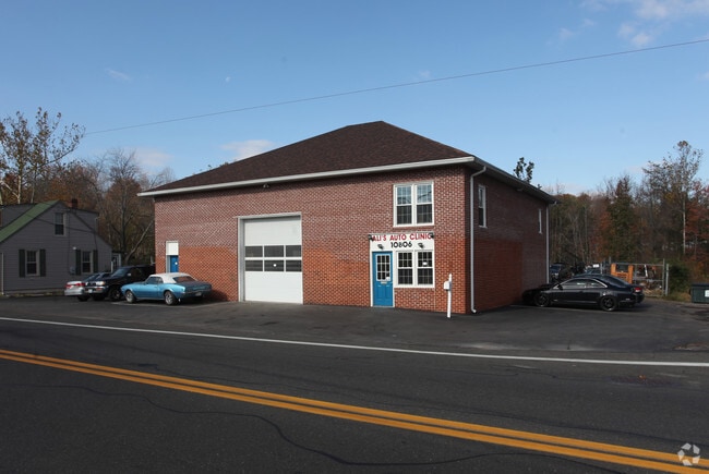
Property Record
10806 Lanham Severn Rd, Lanham, MD 20706
NEARBY LISTINGS FOR SALE OR LEASE
Property Detail
10806 Lanham Severn Rd
14-1623883
GLENDALE
Autorepair
Prince George's
A
Maryland
24033C0155E
0.29 AC
2024
Greenbelt
2025
Washington, DC
800413
Washington-Arlington-Alexandria, DC-VA-MD-WV
2,484 SF
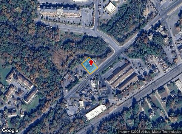
DEMOGRAPHICS near 10806 Lanham Severn Rd
1 mile
3 mile
5 mile
2024 Total Population
11,673
70,009
187,542
2029 Population
11,529
68,299
183,265
Pop Growth 2024-2029
(1.23%)
(2.44%)
(2.28%)
Average Age
39
40
40
2024 Total Households
3,803
22,426
61,263
HH Growth 2024-2029
(1.21%)
(2.58%)
(2.39%)
Median Household Inc
$99,115
$110,652
$106,000
Avg Household Size
3.00
3.00
2.90
2024 Avg HH Vehicles
2.00
2.00
2.00
Median Home Value
$445,980
$414,717
$404,802
Median Year Built
1983
1982
1976
Nearby Places
Map Layers
Map Styles
 Street
 Aerial
Transit
 Traffic
 Biking
Places
Listings with unknown addresses are not visible on the map
- Restaurants
- Banks
- Shops
- Fitness
- Groceries
PUBLIC TRANSPORTATION
COMMUTER RAIL
Seabrook (Penn Line - Maryland Area Regional Commuter Trains (The MARC))
Drive
Walk
Distance
Seabrook (Penn Line - Maryland Area Regional Commuter Trains (The MARC))
3 min
1.5 mi
New Carrollton (Penn Line - Maryland Area Regional Commuter Trains (The MARC))
Drive
Walk
Distance
New Carrollton (Penn Line - Maryland Area Regional Commuter Trains (The MARC))
8 min
4.0 mi
AIRPORT
Ronald Reagan Washington Ntl
Drive
Walk
Distance
Ronald Reagan Washington Ntl
33 min
18.9 mi
Baltimore/Washington International Thurgood Marshall
Drive
Walk
Distance
Baltimore/Washington International Thurgood Marshall
35 min
21.6 mi
Washington Dulles International
Drive
Walk
Distance
Washington Dulles International
62 min
41.9 mi
Freight Ports
Port of Baltimore
Drive
Walk
Distance
Port of Baltimore
43 min
27.9 mi
Nearby Properties
Address
Land Use
TOTAL SIZE
Lot Size
Zoning
Address
Land Use
TOTAL SIZE
Lot Size
Zoning
452.74 AC
ROS
Address
Land Use
TOTAL SIZE
Lot Size
Zoning
413,915 SF
39.86 AC
IE
Address
Land Use
TOTAL SIZE
Lot Size
Zoning
290,728 SF
29.27 AC
RSF95
Address
Land Use
TOTAL SIZE
Lot Size
Zoning
264,093 SF
22.74 AC
CGO
Address
Land Use
TOTAL SIZE
Lot Size
Zoning
27.07 AC
RMF20
Address
Land Use
TOTAL SIZE
Lot Size
Zoning
21.35 AC
RMF20
Address
Land Use
TOTAL SIZE
Lot Size
Zoning
1,849.51 AC
ROS
Address
Land Use
TOTAL SIZE
Lot Size
Zoning
305,375 SF
39.83 AC
RSF65
Address
Land Use
TOTAL SIZE
Lot Size
Zoning
20.50 AC
RMF20
Address
Land Use
TOTAL SIZE
Lot Size
Zoning
104,397 SF
27.71 AC
AG
Address
Land Use
TOTAL SIZE
Lot Size
Zoning
19.97 AC
RMF12
Address
Land Use
TOTAL SIZE
Lot Size
Zoning
17.68 AC
RMF20
Address
Land Use
TOTAL SIZE
Lot Size
Zoning
7.65 AC
RMF20
Address
Land Use
TOTAL SIZE
Lot Size
Zoning
329,080 SF
15.31 AC
IE
Address
Land Use
TOTAL SIZE
Lot Size
Zoning
317 SF
14.09 AC
RMF20
Address
Land Use
TOTAL SIZE
Lot Size
Zoning
1,296 SF
10.78 AC
RMF20
Address
Land Use
TOTAL SIZE
Lot Size
Zoning
192,270 SF
16.35 AC
CGO
Address
Land Use
TOTAL SIZE
Lot Size
Zoning
212,073 SF
32.80 AC
RSF95
Address
Land Use
TOTAL SIZE
Lot Size
Zoning
11.49 AC
RMF12
Address
Land Use
TOTAL SIZE
Lot Size
Zoning
13.54 AC
RMF20
Address
Land Use
TOTAL SIZE
Lot Size
Zoning
73,340 SF
10.72 AC
IE
Address
Land Use
TOTAL SIZE
Lot Size
Zoning
111,684 SF
10.93 AC
CGO
Address
Land Use
TOTAL SIZE
Lot Size
Zoning
88,440 SF
1.54 AC
IE
Address
Land Use
TOTAL SIZE
Lot Size
Zoning
85,477 SF
10.17 AC
RSF95
Address
Land Use
TOTAL SIZE
Lot Size
Zoning
71,904 SF
0.48 AC
RSF95
Address
Land Use
TOTAL SIZE
Lot Size
Zoning
129,573 SF
2.49 AC
IE
Address
Land Use
TOTAL SIZE
Lot Size
Zoning
47,132 SF
3.53 AC
LMXC
Address
Land Use
TOTAL SIZE
Lot Size
Zoning
113,902 SF
4.08 AC
IE
Address
Land Use
TOTAL SIZE
Lot Size
Zoning
103,636 SF
20.61 AC
RSF95
Address
Land Use
TOTAL SIZE
Lot Size
Zoning
99,492 SF
9.20 AC
CGO
The World's #1 Commercial Real Estate Marketplace
Connect with us
© 2026 CoStar Group
The information above has been obtained from sources believed reliable. While we do not doubt its accuracy we have not verified it and make no guarantee, warranty or representation about it. It is your responsibility to independently confirm its accuracy and completeness. Any projections, opinions, assumptions, or estimates used are for example only and do not represent the current or future performance of the property. The value of this transaction to you depends on tax and other factors which should be evaluated by your tax, financial, and legal advisors. You and your advisors should conduct a careful, independent investigation of the property to determine to your satisfaction the suitability of the property for your needs.