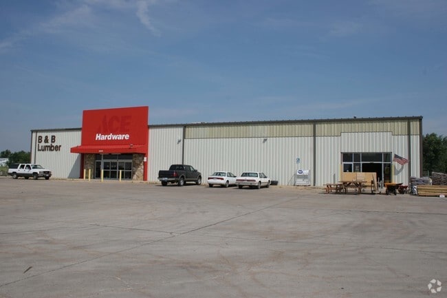
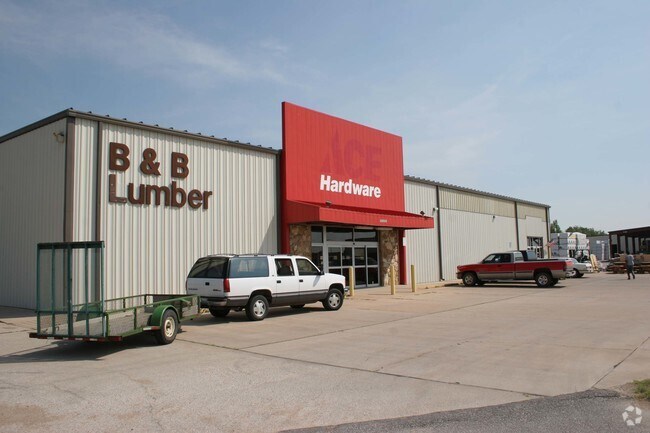
Property Record
10808 W Macarthur Rd, Wichita, KS 67215
NEARBY LISTINGS FOR SALE OR LEASE
-
-
View all Wichita listings for sale on LoopNet.com
Property Detail
10808 W Macarthur Rd
Wichita, KS
Baalmann 3Rd Add
203-07-0-44-01-001.00
LOT 1 BAALMANN 3RD. ADD.
Warehouse
Sedgwick
X
Kansas
20173C0477G
1
2024
4.87 AC
2025
Airport
009605
Wichita
59,250 SF
DEMOGRAPHICS near 10808 W Macarthur Rd
1 Mile
3 Mile
5 Mile
2024 Total Population
566
10,827
38,204
2029 Population
565
10,846
38,432
Pop Growth 2024-2029
(0.18%)
+ 0.18%
+ 0.60%
Average Age
36
36
40
2024 Total Households
189
3,659
13,955
HH Growth 2024-2029
(0.53%)
+ 0.14%
+ 0.54%
Median Household Inc
$108,654
$95,976
$85,538
Avg Household Size
3.00
2.90
2.70
2024 Avg HH Vehicles
2.00
2.00
2.00
Median Home Value
$198,809
$173,319
$193,995
Median Year Built
1996
1995
1991
Nearby Places
Map Layers
Map Styles
 Street
 Aerial
- Restaurants
- Banks
- Shops
- Fitness
- Groceries
PUBLIC TRANSPORTATION
AIRPORT
Wichita Dwight D Eisenhower Ntl
DRIVE
WALK
Distance
Wichita Dwight D Eisenhower Ntl
13 min
6.3 mi
Freight Ports
Tulsa Port Of Catoosa
DRIVE
WALK
Distance
Tulsa Port Of Catoosa
210 min
195.9 mi
Nearby Properties
Address
Land Use
TOTAL SIZE
Lot Size
Zoning
Address
Land Use
TOTAL SIZE
Lot Size
Zoning
395,143 SF
3.58 AC
LI
Address
Land Use
TOTAL SIZE
Lot Size
Zoning
1,677,015 SF
49.80 AC
LI,SF-20
Address
Land Use
TOTAL SIZE
Lot Size
Zoning
60,900 SF
281.77 AC
SF-5
Address
Land Use
TOTAL SIZE
Lot Size
Zoning
58,588 SF
11.08 AC
SF-5
Address
Land Use
TOTAL SIZE
Lot Size
Zoning
53,402 SF
26.35 AC
SF-5
Address
Land Use
TOTAL SIZE
Lot Size
Zoning
34,848 SF
8.24 AC
SF-5
Address
Land Use
TOTAL SIZE
Lot Size
Zoning
24,767 SF
8.96 AC
SF-5
Address
Land Use
TOTAL SIZE
Lot Size
Zoning
419,955 SF
52.55 AC
LI
Address
Land Use
TOTAL SIZE
Lot Size
Zoning
495,563 SF
72.04 AC
LI
Address
Land Use
TOTAL SIZE
Lot Size
Zoning
25,144 SF
3.91 AC
LI
Address
Land Use
TOTAL SIZE
Lot Size
Zoning
5,396 SF
138.07 AC
SF-5
Address
Land Use
TOTAL SIZE
Lot Size
Zoning
78,920 SF
22.15 AC
LI
Address
Land Use
TOTAL SIZE
Lot Size
Zoning
241,237 SF
28.46 AC
LI
Address
Land Use
TOTAL SIZE
Lot Size
Zoning
31,771 SF
1.16 AC
LC
Address
Land Use
TOTAL SIZE
Lot Size
Zoning
28,015 SF
24.72 AC
LI
Address
Land Use
TOTAL SIZE
Lot Size
Zoning
116,415 SF
11.14 AC
LI
Address
Land Use
TOTAL SIZE
Lot Size
Zoning
37,100 SF
1.03 AC
LI
Address
Land Use
TOTAL SIZE
Lot Size
Zoning
68,374 SF
6.96 AC
LI
Address
Land Use
TOTAL SIZE
Lot Size
Zoning
36,780 SF
13.61 AC
GC,LI
Address
Land Use
TOTAL SIZE
Lot Size
Zoning
71,316 SF
10 AC
LI
Address
Land Use
TOTAL SIZE
Lot Size
Zoning
60,708 SF
13.01 AC
LI
Address
Land Use
TOTAL SIZE
Lot Size
Zoning
86,090 SF
3.03 AC
LI
Address
Land Use
TOTAL SIZE
Lot Size
Zoning
42,612 SF
8.80 AC
LI
Address
Land Use
TOTAL SIZE
Lot Size
Zoning
26,220 SF
1.71 AC
LI
Address
Land Use
TOTAL SIZE
Lot Size
Zoning
90,438 SF
4.97 AC
LI
Address
Land Use
TOTAL SIZE
Lot Size
Zoning
70.73 AC
SF-5
Address
Land Use
TOTAL SIZE
Lot Size
Zoning
78.69 AC
SF-5
Address
Land Use
TOTAL SIZE
Lot Size
Zoning
47,196 SF
0.45 AC
LI
Address
Land Use
TOTAL SIZE
Lot Size
Zoning
73,740 SF
5.99 AC
LI
Address
Land Use
TOTAL SIZE
Lot Size
Zoning
54,430 SF
3.03 AC
LI
The World's #1 Commercial Real Estate Marketplace
Connect with us
© 2026 CoStar Group
The information above has been obtained from sources believed reliable. While we do not doubt its accuracy we have not verified it and make no guarantee, warranty or representation about it. It is your responsibility to independently confirm its accuracy and completeness. Any projections, opinions, assumptions, or estimates used are for example only and do not represent the current or future performance of the property. The value of this transaction to you depends on tax and other factors which should be evaluated by your tax, financial, and legal advisors. You and your advisors should conduct a careful, independent investigation of the property to determine to your satisfaction the suitability of the property for your needs.