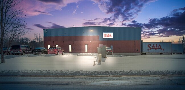
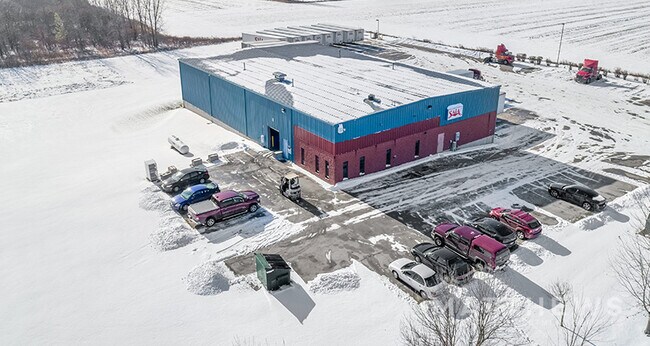
Property Record
1081 Flightway Dr, De Pere, WI 54115
NEARBY LISTINGS FOR SALE OR LEASE
Property Detail
1081 Flightway Dr
Green Bay
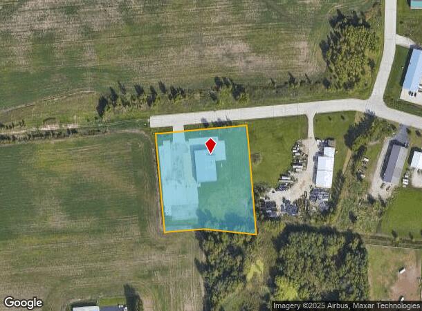
Certified Survey Map
Green Bay, WI
152,784 SQ FT LOT 1 OF 40 CSM 276 MAP 6126 IN 1750427 BNG PRT OF NE1/4 SW1/4 & BNG PRT OF SE1/4 SW1/4 SEC 24 T23N R19E & PART IN 1754807
HB-328-5
Brown
Commercialnec
Wisconsin
2024
1
2024
3.51 AC
940008
Ashwaubenon
DEMOGRAPHICS near 1081 Flightway Dr
1 mile
3 mile
5 mile
2024 Total Population
1,803
16,066
56,034
2029 Population
1,856
16,497
57,212
Pop Growth 2024-2029
+ 2.94%
+ 2.68%
+ 2.10%
Average Age
36
39
40
2024 Total Households
843
6,689
22,714
HH Growth 2024-2029
+ 3.20%
+ 2.72%
+ 2.24%
Median Household Inc
$73,392
$88,586
$76,186
Avg Household Size
2.10
2.40
2.40
2024 Avg HH Vehicles
2.00
2.00
2.00
Median Home Value
$285,673
$285,491
$260,578
Median Year Built
2010
2001
1986
Nearby Places
Map Layers
Map Styles
 Street
 Aerial
Transit
 Traffic
 Biking
Places
Listings with unknown addresses are not visible on the map
- Restaurants
- Banks
- Shops
- Fitness
- Groceries
PUBLIC TRANSPORTATION
AIRPORT
Green Bay/Austin Straubel International
Drive
Walk
Distance
Green Bay/Austin Straubel International
10 min
4.0 mi
Appleton International
Drive
Walk
Distance
Appleton International
41 min
31.6 mi
SALE & LEASE HISTORY
LISTING DATE
SALE/LEASE

May 05, 2020
For Sale
Feb 22, 2021
For Lease
Feb 19, 2021
For Lease
Feb 19, 2021
For Lease
Nearby Properties
Address
Land Use
TOTAL SIZE
Lot Size
Zoning
Address
Land Use
TOTAL SIZE
Lot Size
Zoning
175,271 SF
17.86 AC
Address
Land Use
TOTAL SIZE
Lot Size
Zoning
452,950 SF
34.59 AC
Address
Land Use
TOTAL SIZE
Lot Size
Zoning
25.31 AC
Address
Land Use
TOTAL SIZE
Lot Size
Zoning
20.53 AC
Address
Land Use
TOTAL SIZE
Lot Size
Zoning
71.85 AC
Address
Land Use
TOTAL SIZE
Lot Size
Zoning
35.24 AC
Address
Land Use
TOTAL SIZE
Lot Size
Zoning
53.92 AC
Address
Land Use
TOTAL SIZE
Lot Size
Zoning
487,996 SF
23.04 AC
Address
Land Use
TOTAL SIZE
Lot Size
Zoning
339,679 SF
56.88 AC
Address
Land Use
TOTAL SIZE
Lot Size
Zoning
18.98 AC
Address
Land Use
TOTAL SIZE
Lot Size
Zoning
26.42 AC
Address
Land Use
TOTAL SIZE
Lot Size
Zoning
37.22 AC
Address
Land Use
TOTAL SIZE
Lot Size
Zoning
174,436 SF
12.23 AC
Address
Land Use
TOTAL SIZE
Lot Size
Zoning
98,000 SF
10.84 AC
Address
Land Use
TOTAL SIZE
Lot Size
Zoning
43.27 AC
Address
Land Use
TOTAL SIZE
Lot Size
Zoning
14.02 AC
Address
Land Use
TOTAL SIZE
Lot Size
Zoning
240,000 SF
12.56 AC
Address
Land Use
TOTAL SIZE
Lot Size
Zoning
189,186 SF
17.54 AC
Address
Land Use
TOTAL SIZE
Lot Size
Zoning
17.84 AC
Address
Land Use
TOTAL SIZE
Lot Size
Zoning
245,300 SF
17.28 AC
Address
Land Use
TOTAL SIZE
Lot Size
Zoning
200,000 SF
15.27 AC
Address
Land Use
TOTAL SIZE
Lot Size
Zoning
12.08 AC
Address
Land Use
TOTAL SIZE
Lot Size
Zoning
84,818 SF
4.73 AC
Address
Land Use
TOTAL SIZE
Lot Size
Zoning
12.44 AC
Address
Land Use
TOTAL SIZE
Lot Size
Zoning
181,298 SF
10.02 AC
Address
Land Use
TOTAL SIZE
Lot Size
Zoning
9.33 AC
Address
Land Use
TOTAL SIZE
Lot Size
Zoning
3.42 AC
Address
Land Use
TOTAL SIZE
Lot Size
Zoning
180,760 SF
14.98 AC
Address
Land Use
TOTAL SIZE
Lot Size
Zoning
61,800 SF
7.60 AC
Address
Land Use
TOTAL SIZE
Lot Size
Zoning
16.45 AC
The World's #1 Commercial Real Estate Marketplace
Connect with us
© 2026 CoStar Group
The information above has been obtained from sources believed reliable. While we do not doubt its accuracy we have not verified it and make no guarantee, warranty or representation about it. It is your responsibility to independently confirm its accuracy and completeness. Any projections, opinions, assumptions, or estimates used are for example only and do not represent the current or future performance of the property. The value of this transaction to you depends on tax and other factors which should be evaluated by your tax, financial, and legal advisors. You and your advisors should conduct a careful, independent investigation of the property to determine to your satisfaction the suitability of the property for your needs.