Property Record
10815 Hames Rd, Pilot Point, TX 76258

Save to a Folder
{{folder.Name}}
{{folder.ListingIds.length}} Properties
{{folder.ListingIds.length}} Property
Create a New Folder
Property Detail
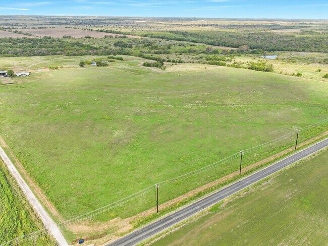
10815 Hames Rd
R149155
A0522A J. HARRIS, TR 27, 48.963 ACRES
Agriculturalland
DENTON
A Areas with a 1% annual chance of flooding and a 26% chance of flooding over the life of a 30-year mortgage.
Texas
2025
48.96 AC
2025
Outlying Denton County
020129
Dallas/Ft Worth
2,913 SF
Dallas-Fort Worth-Arlington, TX
NEARBY LISTINGS FOR SALE OR LEASE
DEMOGRAPHICS near 10815 Hames Rd
1 mile
3 mile
5 mile
2025 Total Population
38
399
4,084
2030 Population
47
471
4,826
Pop Growth 2025-2030
+ 23.68%
+ 18.05%
+ 18.17%
Average Age
34
40
39
2025 Total Households
12
135
1,345
HH Growth 2025-2030
+ 25.00%
+ 18.52%
+ 17.70%
Median Household Inc
$137,500
$115,277
$116,340
Avg Household Size
3.30
2.90
2.90
2025 Avg HH Vehicles
3.00
3.00
3.00
Median Home Value
$550,000
$669,355
$610,559
Median Year Built
2011
2010
2010
Nearby Places
Map Layers
Map Styles
 Street
 Aerial
Layers
 Traffic
 Biking
Places
Listings with unknown addresses are not visible on the map
- Restaurants
- Banks
- Shops
- Fitness
- Groceries
SALE & LEASE HISTORY
LISTING DATE
SALE/LEASE

Oct 01, 2024
For Sale
Nearby Properties
Address
Land Use
TOTAL SIZE
Lot Size
Zoning
Address
Land Use
TOTAL SIZE
Lot Size
Zoning
29.12 AC
Address
Land Use
TOTAL SIZE
Lot Size
Zoning
87.08 AC
AG
Address
Land Use
TOTAL SIZE
Lot Size
Zoning
21.45 AC
Address
Land Use
TOTAL SIZE
Lot Size
Zoning
51.62 AC
AG
Address
Land Use
TOTAL SIZE
Lot Size
Zoning
14.57 AC
Address
Land Use
TOTAL SIZE
Lot Size
Zoning
7,084 SF
116.89 AC
Address
Land Use
TOTAL SIZE
Lot Size
Zoning
13.75 AC
COMM
Address
Land Use
TOTAL SIZE
Lot Size
Zoning
5,628 SF
34 AC
Address
Land Use
TOTAL SIZE
Lot Size
Zoning
88.12 AC
Address
Land Use
TOTAL SIZE
Lot Size
Zoning
118.80 AC
Address
Land Use
TOTAL SIZE
Lot Size
Zoning
8,146 SF
4.75 AC
Address
Land Use
TOTAL SIZE
Lot Size
Zoning
12,878 SF
1 AC
Address
Land Use
TOTAL SIZE
Lot Size
Zoning
6,400 SF
12.10 AC
Address
Land Use
TOTAL SIZE
Lot Size
Zoning
13,075 SF
368.74 AC
Address
Land Use
TOTAL SIZE
Lot Size
Zoning
14.03 AC
AG
Address
Land Use
TOTAL SIZE
Lot Size
Zoning
6,265 SF
21.69 AC
Address
Land Use
TOTAL SIZE
Lot Size
Zoning
8,340 SF
46.50 AC
Address
Land Use
TOTAL SIZE
Lot Size
Zoning
10.65 AC
Address
Land Use
TOTAL SIZE
Lot Size
Zoning
2,880 SF
9.57 AC
Address
Land Use
TOTAL SIZE
Lot Size
Zoning
3,120 SF
5 AC
Address
Land Use
TOTAL SIZE
Lot Size
Zoning
2,688 SF
7.79 AC
Address
Land Use
TOTAL SIZE
Lot Size
Zoning
11,940 SF
4.72 AC
Address
Land Use
TOTAL SIZE
Lot Size
Zoning
3,488 SF
5.25 AC
Address
Land Use
TOTAL SIZE
Lot Size
Zoning
3,300 SF
2.86 AC
Address
Land Use
TOTAL SIZE
Lot Size
Zoning
6,869 SF
5 AC
Address
Land Use
TOTAL SIZE
Lot Size
Zoning
2,720 SF
5 AC
The World's #1 Commercial Real Estate Marketplace
Connect with us
© 2026 CoStar Group
The information above has been obtained from sources believed reliable. While we do not doubt its accuracy we have not verified it and make no guarantee, warranty or representation about it. It is your responsibility to independently confirm its accuracy and completeness. Any projections, opinions, assumptions, or estimates used are for example only and do not represent the current or future performance of the property. The value of this transaction to you depends on tax and other factors which should be evaluated by your tax, financial, and legal advisors. You and your advisors should conduct a careful, independent investigation of the property to determine to your satisfaction the suitability of the property for your needs.