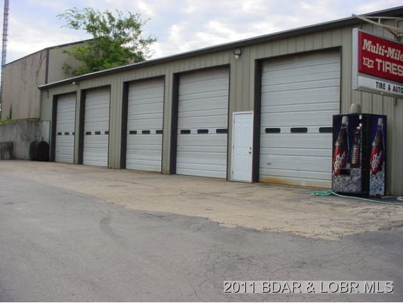
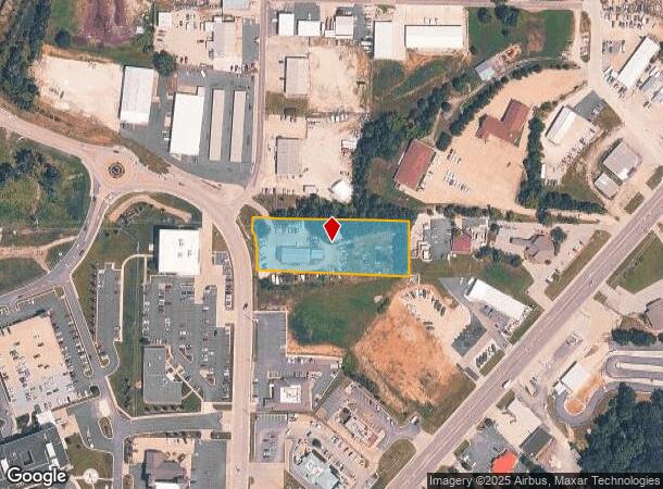
Property Record
1082 Nichols Rd, Osage Beach, MO 65065
NEARBY LISTINGS FOR SALE OR LEASE
Property Detail
1082 Nichols Rd
Commercialnec
PT SW NW TH W 450' OF N 150' OF SW NW LESS RD RW
X
Camden
29029C0235C
Missouri
2025
1.60 AC
2025
Missouri South Central Area
950201
Other Market Areas
5,568 SF
08-5.0-15.0-000.0-002-008.000
DEMOGRAPHICS near 1082 Nichols Rd
1 Mile
3 Mile
5 Mile
2024 Total Population
198
6,275
13,232
2029 Population
213
6,704
14,155
Pop Growth 2024-2029
+ 7.58%
+ 6.84%
+ 6.98%
Average Age
47
47
48
2024 Total Households
90
2,882
5,988
HH Growth 2024-2029
+ 6.67%
+ 6.04%
+ 6.21%
Median Household Inc
$55,999
$59,895
$66,555
Avg Household Size
2.10
2.10
2.10
2024 Avg HH Vehicles
2.00
2.00
2.00
Median Home Value
$257,142
$240,641
$292,319
Median Year Built
1984
1985
1986
Nearby Places
Map Layers
Map Styles
 Street
 Aerial
- Restaurants
- Banks
- Shops
- Fitness
- Groceries
SALE & LEASE HISTORY
LISTING DATE
SALE/LEASE

Sep 24, 2016
For Sale
Nearby Properties
Address
Land Use
TOTAL SIZE
Lot Size
Zoning
Address
Land Use
TOTAL SIZE
Lot Size
Zoning
Address
Land Use
TOTAL SIZE
Lot Size
Zoning
Address
Land Use
TOTAL SIZE
Lot Size
Zoning
4.36 AC
Address
Land Use
TOTAL SIZE
Lot Size
Zoning
34,804 SF
1.60 AC
Address
Land Use
TOTAL SIZE
Lot Size
Zoning
26,640 SF
2.01 AC
Address
Land Use
TOTAL SIZE
Lot Size
Zoning
11,360 SF
7.50 AC
Address
Land Use
TOTAL SIZE
Lot Size
Zoning
53,260 SF
7.26 AC
Address
Land Use
TOTAL SIZE
Lot Size
Zoning
4,508 SF
2.38 AC
Address
Land Use
TOTAL SIZE
Lot Size
Zoning
Address
Land Use
TOTAL SIZE
Lot Size
Zoning
Address
Land Use
TOTAL SIZE
Lot Size
Zoning
11.23 AC
Address
Land Use
TOTAL SIZE
Lot Size
Zoning
8,123 SF
0.85 AC
Address
Land Use
TOTAL SIZE
Lot Size
Zoning
10,246 SF
0.71 AC
Address
Land Use
TOTAL SIZE
Lot Size
Zoning
7,527 SF
1.30 AC
Address
Land Use
TOTAL SIZE
Lot Size
Zoning
Address
Land Use
TOTAL SIZE
Lot Size
Zoning
Address
Land Use
TOTAL SIZE
Lot Size
Zoning
Address
Land Use
TOTAL SIZE
Lot Size
Zoning
968 SF
1.90 AC
Address
Land Use
TOTAL SIZE
Lot Size
Zoning
16,752 SF
1.90 AC
Address
Land Use
TOTAL SIZE
Lot Size
Zoning
Address
Land Use
TOTAL SIZE
Lot Size
Zoning
19,950 SF
1.70 AC
Address
Land Use
TOTAL SIZE
Lot Size
Zoning
16,975 SF
1.50 AC
Address
Land Use
TOTAL SIZE
Lot Size
Zoning
18,368 SF
0.95 AC
Address
Land Use
TOTAL SIZE
Lot Size
Zoning
5,395 SF
0.97 AC
Address
Land Use
TOTAL SIZE
Lot Size
Zoning
Address
Land Use
TOTAL SIZE
Lot Size
Zoning
5,158 SF
1.50 AC
Address
Land Use
TOTAL SIZE
Lot Size
Zoning
Address
Land Use
TOTAL SIZE
Lot Size
Zoning
Address
Land Use
TOTAL SIZE
Lot Size
Zoning
2,176 SF
7.12 AC
Address
Land Use
TOTAL SIZE
Lot Size
Zoning
The World's #1 Commercial Real Estate Marketplace
Connect with us
© 2025 CoStar Group
The information above has been obtained from sources believed reliable. While we do not doubt its accuracy we have not verified it and make no guarantee, warranty or representation about it. It is your responsibility to independently confirm its accuracy and completeness. Any projections, opinions, assumptions, or estimates used are for example only and do not represent the current or future performance of the property. The value of this transaction to you depends on tax and other factors which should be evaluated by your tax, financial, and legal advisors. You and your advisors should conduct a careful, independent investigation of the property to determine to your satisfaction the suitability of the property for your needs.