Property Record
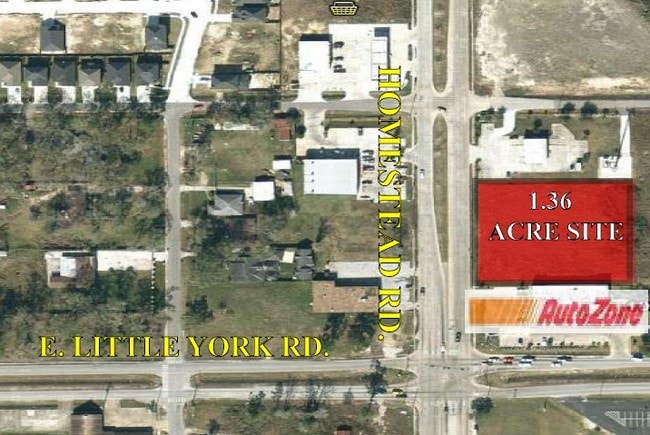
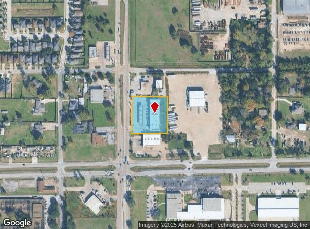
10820 Homestead Rd, Houston, TX 77016

NEARBY LISTINGS FOR SALE OR LEASE
Property Detail
10820 Homestead Rd
1388260010001
Homestead Express
Servicestationmarket
RES A BLK 1 HOMESTEAD EXPRESS
X
Harris
48201C0685L
Texas
2024
1.36 AC
2025
Northeast Near
231900
Houston
12,000 SF
Houston-The Woodlands-Sugar Land, TX
DEMOGRAPHICS near 10820 Homestead Rd
1 Mile
3 Mile
5 Mile
2024 Total Population
12,884
87,207
206,675
2029 Population
13,131
89,215
211,188
Pop Growth 2024-2029
+ 1.92%
+ 2.30%
+ 2.18%
Average Age
39
36
35
2024 Total Households
4,216
26,604
63,006
HH Growth 2024-2029
+ 1.90%
+ 2.32%
+ 2.20%
Median Household Inc
$39,187
$35,540
$37,202
Avg Household Size
3.00
3.20
3.20
2024 Avg HH Vehicles
2.00
2.00
2.00
Median Home Value
$95,680
$103,373
$121,960
Median Year Built
1966
1967
1969
Nearby Places
- Restaurants
- Banks
- Shops
- Fitness
- Groceries
PUBLIC TRANSPORTATION
AIRPORT
George Bush Intcntl/Houston
DRIVE
WALK
Distance
George Bush Intcntl/Houston
15 min
9.4 mi
William P Hobby
DRIVE
WALK
Distance
William P Hobby
35 min
20.1 mi
Freight Ports
Port of Houston
DRIVE
WALK
Distance
Port of Houston
22 min
12.1 mi
SALE & LEASE HISTORY
LISTING DATE
SALE/LEASE

Sep 24, 2016
For Sale
Nearby Properties
Address
Land Use
TOTAL SIZE
Lot Size
Zoning
Address
Land Use
TOTAL SIZE
Lot Size
Zoning
144,823 SF
80 AC
Address
Land Use
TOTAL SIZE
Lot Size
Zoning
215,705 SF
39.58 AC
Address
Land Use
TOTAL SIZE
Lot Size
Zoning
139,252 SF
4.55 AC
Address
Land Use
TOTAL SIZE
Lot Size
Zoning
132,902 SF
6.12 AC
Address
Land Use
TOTAL SIZE
Lot Size
Zoning
91,623 SF
9.09 AC
Address
Land Use
TOTAL SIZE
Lot Size
Zoning
200,186 SF
13.20 AC
Address
Land Use
TOTAL SIZE
Lot Size
Zoning
261,236 SF
11.57 AC
Address
Land Use
TOTAL SIZE
Lot Size
Zoning
81,067 SF
35.13 AC
Address
Land Use
TOTAL SIZE
Lot Size
Zoning
219,230 SF
9.92 AC
Address
Land Use
TOTAL SIZE
Lot Size
Zoning
148,981 SF
6.53 AC
Address
Land Use
TOTAL SIZE
Lot Size
Zoning
230,024 SF
15.34 AC
Address
Land Use
TOTAL SIZE
Lot Size
Zoning
130,309 SF
13.28 AC
Address
Land Use
TOTAL SIZE
Lot Size
Zoning
1,500 SF
106.21 AC
Address
Land Use
TOTAL SIZE
Lot Size
Zoning
102,214 SF
11.26 AC
Address
Land Use
TOTAL SIZE
Lot Size
Zoning
103,817 SF
11.29 AC
Address
Land Use
TOTAL SIZE
Lot Size
Zoning
352,503 SF
20.41 AC
Address
Land Use
TOTAL SIZE
Lot Size
Zoning
102,252 SF
5.93 AC
Address
Land Use
TOTAL SIZE
Lot Size
Zoning
210,869 SF
8.43 AC
Address
Land Use
TOTAL SIZE
Lot Size
Zoning
149,910 SF
6.57 AC
Address
Land Use
TOTAL SIZE
Lot Size
Zoning
288,992 SF
6.56 AC
Address
Land Use
TOTAL SIZE
Lot Size
Zoning
164,377 SF
32.46 AC
Address
Land Use
TOTAL SIZE
Lot Size
Zoning
120,288 SF
9.30 AC
Address
Land Use
TOTAL SIZE
Lot Size
Zoning
68,140 SF
8.49 AC
Address
Land Use
TOTAL SIZE
Lot Size
Zoning
148,266 SF
9.16 AC
Address
Land Use
TOTAL SIZE
Lot Size
Zoning
62,031 SF
22.59 AC
Address
Land Use
TOTAL SIZE
Lot Size
Zoning
132,508 SF
5.78 AC
Address
Land Use
TOTAL SIZE
Lot Size
Zoning
111,892 SF
6.51 AC
Address
Land Use
TOTAL SIZE
Lot Size
Zoning
104,553 SF
11.28 AC
Address
Land Use
TOTAL SIZE
Lot Size
Zoning
61,200 SF
5.25 AC
Address
Land Use
TOTAL SIZE
Lot Size
Zoning
169,148 SF
11.15 AC
The World's #1 Commercial Real Estate Marketplace
Connect with us
© 2025 CoStar Group
The information above has been obtained from sources believed reliable. While we do not doubt its accuracy we have not verified it and make no guarantee, warranty or representation about it. It is your responsibility to independently confirm its accuracy and completeness. Any projections, opinions, assumptions, or estimates used are for example only and do not represent the current or future performance of the property. The value of this transaction to you depends on tax and other factors which should be evaluated by your tax, financial, and legal advisors. You and your advisors should conduct a careful, independent investigation of the property to determine to your satisfaction the suitability of the property for your needs.