Property Record
10821 Plantside Dr, Louisville, KY 40299
Current Lease Availabilities
NEARBY LISTINGS FOR SALE OR LEASE
Property Detail
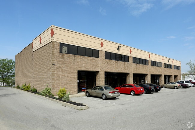
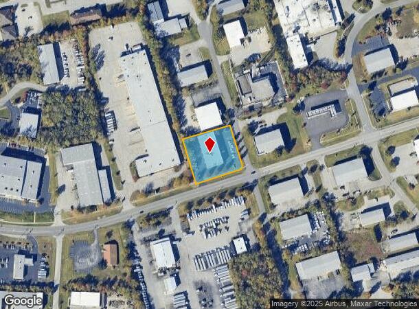
10821 Plantside Dr
Louisville/Jefferson County, KY-IN
Holloway Industrial Park
252100150000
LOT 15 HOLLOWAY INDUSTRIAL PARK SUBDIVISION, SEC. 1, PB. 37, PG. 41, 0.9918 AC +/-
Warehouse
Jefferson
X
Kentucky
21111C0064F
15
2025
0.99 AC
2025
Southeast
011116
Louisville
17,140 SF
DEMOGRAPHICS near 10821 Plantside Dr
1 Mile
3 Mile
5 Mile
2024 Total Population
1,477
65,852
162,383
2029 Population
1,446
64,862
159,918
Pop Growth 2024-2029
(2.10%)
(1.50%)
(1.52%)
Average Age
41
42
41
2024 Total Households
655
28,146
69,673
HH Growth 2024-2029
(2.14%)
(1.55%)
(1.52%)
Median Household Inc
$77,644
$81,601
$78,397
Avg Household Size
2.20
2.30
2.30
2024 Avg HH Vehicles
2.00
2.00
2.00
Median Home Value
$187,974
$268,932
$259,317
Median Year Built
1969
1983
1981
Nearby Places
Map Layers
Map Styles
 Street
 Aerial
- Restaurants
- Banks
- Shops
- Fitness
- Groceries
PUBLIC TRANSPORTATION
AIRPORT
Louisville Muhammad Ali International
DRIVE
WALK
Distance
Louisville Muhammad Ali International
31 min
15.1 mi
Nearby Properties
Address
Land Use
TOTAL SIZE
Lot Size
Zoning
Address
Land Use
TOTAL SIZE
Lot Size
Zoning
115.43 AC
R4-RESIDEN
Address
Land Use
TOTAL SIZE
Lot Size
Zoning
2,776 SF
34.17 AC
R4-RESIDEN
Address
Land Use
TOTAL SIZE
Lot Size
Zoning
1,194 SF
38.74 AC
R4-RESIDEN
Address
Land Use
TOTAL SIZE
Lot Size
Zoning
Address
Land Use
TOTAL SIZE
Lot Size
Zoning
1,334 SF
24.71 AC
R4-RESIDEN
Address
Land Use
TOTAL SIZE
Lot Size
Zoning
2,140 SF
18.35 AC
R4-RESIDEN
Address
Land Use
TOTAL SIZE
Lot Size
Zoning
8.47 AC
R1-RESIDEN
Address
Land Use
TOTAL SIZE
Lot Size
Zoning
45.92 AC
Address
Land Use
TOTAL SIZE
Lot Size
Zoning
19.57 AC
Address
Land Use
TOTAL SIZE
Lot Size
Zoning
18,394 SF
22.09 AC
C1-COMMERC
Address
Land Use
TOTAL SIZE
Lot Size
Zoning
202,557 SF
6.06 AC
C2-COMMERC
Address
Land Use
TOTAL SIZE
Lot Size
Zoning
31,968 SF
15.34 AC
R4-RESIDEN
Address
Land Use
TOTAL SIZE
Lot Size
Zoning
175,971 SF
18.54 AC
PEC-PLANNE
Address
Land Use
TOTAL SIZE
Lot Size
Zoning
19,568 SF
24.23 AC
R7-RESIDEN
Address
Land Use
TOTAL SIZE
Lot Size
Zoning
9,560 SF
20.31 AC
C1-COMMERC
Address
Land Use
TOTAL SIZE
Lot Size
Zoning
10,026 SF
13.45 AC
R6-RESIDEN
Address
Land Use
TOTAL SIZE
Lot Size
Zoning
10,800 SF
18.70 AC
R6-RESIDEN
Address
Land Use
TOTAL SIZE
Lot Size
Zoning
18,784 SF
16.80 AC
R6-RESIDEN
Address
Land Use
TOTAL SIZE
Lot Size
Zoning
6,846 SF
18.36 AC
R4-RESIDEN
Address
Land Use
TOTAL SIZE
Lot Size
Zoning
910 SF
9.77 AC
R6-RESIDEN
Address
Land Use
TOTAL SIZE
Lot Size
Zoning
28.91 AC
R4-RESIDEN
Address
Land Use
TOTAL SIZE
Lot Size
Zoning
115,168 SF
8.59 AC
C1-COMMERC
Address
Land Use
TOTAL SIZE
Lot Size
Zoning
335,400 SF
18.84 AC
PEC-PLANNE
Address
Land Use
TOTAL SIZE
Lot Size
Zoning
19.91 AC
Address
Land Use
TOTAL SIZE
Lot Size
Zoning
Address
Land Use
TOTAL SIZE
Lot Size
Zoning
2,028 SF
39.89 AC
R4-RESIDEN
Address
Land Use
TOTAL SIZE
Lot Size
Zoning
4,267 SF
10.13 AC
R6-RESIDEN
Address
Land Use
TOTAL SIZE
Lot Size
Zoning
18,084 SF
10.68 AC
R7-RESIDEN
Address
Land Use
TOTAL SIZE
Lot Size
Zoning
Address
Land Use
TOTAL SIZE
Lot Size
Zoning
2,665 SF
6.72 AC
R4-RESIDEN
The World's #1 Commercial Real Estate Marketplace
Connect with us
© 2026 CoStar Group
The information above has been obtained from sources believed reliable. While we do not doubt its accuracy we have not verified it and make no guarantee, warranty or representation about it. It is your responsibility to independently confirm its accuracy and completeness. Any projections, opinions, assumptions, or estimates used are for example only and do not represent the current or future performance of the property. The value of this transaction to you depends on tax and other factors which should be evaluated by your tax, financial, and legal advisors. You and your advisors should conduct a careful, independent investigation of the property to determine to your satisfaction the suitability of the property for your needs.