Property Record
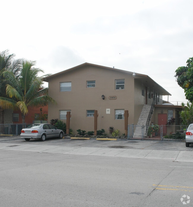
10832 Sw 4Th St, Miami, FL 33174


NEARBY LISTINGS FOR SALE OR LEASE
-
-
View all Miami listings for sale on LoopNet.com
Property Detail
10832 Sw 4Th St
Miami-Miami Beach-Kendall, FL
Sweetwater Groves
25-4006-001-1425
SWEETWATER GROVES PB 8-50 W60FT OF E265FT OF N1/2 OF W1/2 OF LOT 5 BLK 22 AKA LOT 4 NORRIS SUB UR LOT SIZE 60.000 X 100
Multifamilydwelling
Miami/Dade
AH
Florida
12086C0288L
5,4
2024
0.14 AC
2025
Sweetwater Groves
009020
South Florida
4,004 SF
DEMOGRAPHICS near 10832 Sw 4Th St
1 Mile
3 Mile
5 Mile
2024 Total Population
34,189
177,192
385,870
2029 Population
33,156
172,057
375,917
Pop Growth 2024-2029
(3.02%)
(2.90%)
(2.58%)
Average Age
41
43
43
2024 Total Households
10,289
57,880
127,487
HH Growth 2024-2029
(3.72%)
(3.32%)
(2.93%)
Median Household Inc
$49,796
$59,245
$66,211
Avg Household Size
2.90
2.90
2.90
2024 Avg HH Vehicles
2.00
2.00
2.00
Median Home Value
$254,878
$350,274
$383,809
Median Year Built
1978
1979
1982
Nearby Places
Map Layers
Map Styles
 Street
 Aerial
- Restaurants
- Banks
- Shops
- Fitness
- Groceries
PUBLIC TRANSPORTATION
COMMUTER RAIL
Dadeland South (Metrorail Green Line - Miami-Dade Transit (Metrorail/Metromover))
DRIVE
WALK
Distance
Dadeland South (Metrorail Green Line - Miami-Dade Transit (Metrorail/Metromover))
15 min
9.1 mi
Palmetto (Metrorail Green Line - Miami-Dade Transit (Metrorail/Metromover))
DRIVE
WALK
Distance
Palmetto (Metrorail Green Line - Miami-Dade Transit (Metrorail/Metromover))
16 min
9.2 mi
AIRPORT
Miami International
DRIVE
WALK
Distance
Miami International
17 min
7.3 mi
Fort Lauderdale/Hollywood International
DRIVE
WALK
Distance
Fort Lauderdale/Hollywood International
44 min
34.2 mi
Nearby Properties
Address
Land Use
TOTAL SIZE
Lot Size
Zoning
Address
Land Use
TOTAL SIZE
Lot Size
Zoning
2,512,642 SF
100.78 AC
6400
Address
Land Use
TOTAL SIZE
Lot Size
Zoning
4,384,261 SF
343.66 AC
6400
Address
Land Use
TOTAL SIZE
Lot Size
Zoning
784,416 SF
1.72 AC
6480
Address
Land Use
TOTAL SIZE
Lot Size
Zoning
1,680,493 SF
23.71 AC
4100
Address
Land Use
TOTAL SIZE
Lot Size
Zoning
465,663 SF
11.29 AC
4100
Address
Land Use
TOTAL SIZE
Lot Size
Zoning
1,275,460 SF
15.30 AC
6400
Address
Land Use
TOTAL SIZE
Lot Size
Zoning
671,088 SF
19.84 AC
6400
Address
Land Use
TOTAL SIZE
Lot Size
Zoning
448,531 SF
37 AC
6400
Address
Land Use
TOTAL SIZE
Lot Size
Zoning
868,154 SF
1.71 AC
6480
Address
Land Use
TOTAL SIZE
Lot Size
Zoning
762,624 SF
1.70 AC
6480
Address
Land Use
TOTAL SIZE
Lot Size
Zoning
145.77 AC
7700
Address
Land Use
TOTAL SIZE
Lot Size
Zoning
755,156 SF
29.44 AC
7100
Address
Land Use
TOTAL SIZE
Lot Size
Zoning
438,387 SF
16.20 AC
3900
Address
Land Use
TOTAL SIZE
Lot Size
Zoning
428,212 SF
17.56 AC
3900
Address
Land Use
TOTAL SIZE
Lot Size
Zoning
468,411 SF
21.36 AC
7100
Address
Land Use
TOTAL SIZE
Lot Size
Zoning
366,237 SF
9.24 AC
4100
Address
Land Use
TOTAL SIZE
Lot Size
Zoning
476,094 SF
1.09 AC
6480
Address
Land Use
TOTAL SIZE
Lot Size
Zoning
353,267 SF
30.40 AC
6400
Address
Land Use
TOTAL SIZE
Lot Size
Zoning
229,154 SF
9.02 AC
3900
Address
Land Use
TOTAL SIZE
Lot Size
Zoning
540,199 SF
24.93 AC
6400
Address
Land Use
TOTAL SIZE
Lot Size
Zoning
251,834 SF
31.85 AC
6200
Address
Land Use
TOTAL SIZE
Lot Size
Zoning
1,182,342 SF
14.60 AC
7100
Address
Land Use
TOTAL SIZE
Lot Size
Zoning
267,129 SF
16.55 AC
3800
Address
Land Use
TOTAL SIZE
Lot Size
Zoning
318,842 SF
22.14 AC
7100
Address
Land Use
TOTAL SIZE
Lot Size
Zoning
349,295 SF
25.16 AC
6061
Address
Land Use
TOTAL SIZE
Lot Size
Zoning
312,456 SF
15.66 AC
7100
Address
Land Use
TOTAL SIZE
Lot Size
Zoning
197,776 SF
20.15 AC
6600
Address
Land Use
TOTAL SIZE
Lot Size
Zoning
400,278 SF
18.37 AC
7100
Address
Land Use
TOTAL SIZE
Lot Size
Zoning
305,718 SF
3.26 AC
6400
The World's #1 Commercial Real Estate Marketplace
Connect with us
© 2025 CoStar Group
The information above has been obtained from sources believed reliable. While we do not doubt its accuracy we have not verified it and make no guarantee, warranty or representation about it. It is your responsibility to independently confirm its accuracy and completeness. Any projections, opinions, assumptions, or estimates used are for example only and do not represent the current or future performance of the property. The value of this transaction to you depends on tax and other factors which should be evaluated by your tax, financial, and legal advisors. You and your advisors should conduct a careful, independent investigation of the property to determine to your satisfaction the suitability of the property for your needs.