Property Record
10833 Steele Creek Rd, Charlotte, NC 28273
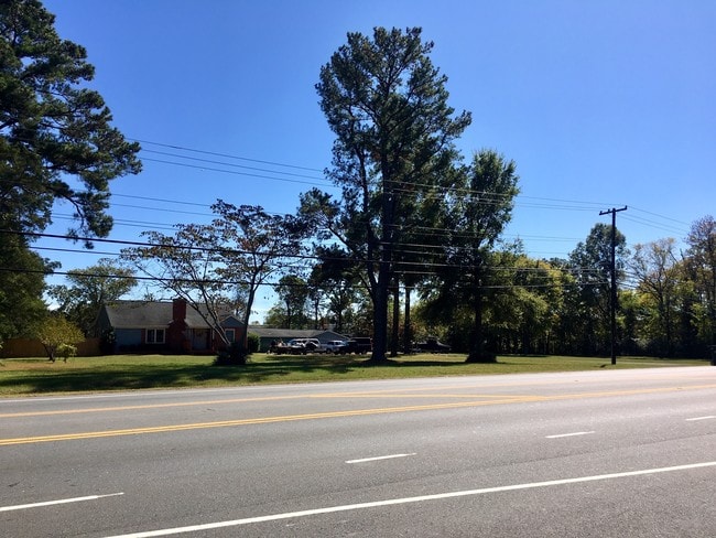

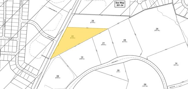
Property Detail
10833 Steele Creek Rd
201-141-01
L1 M71-122
Multifamilydwelling
Mecklenburg
R17MF
North Carolina
B and X Area of moderate flood hazard, usually the area between the limits of the 100-year and 500-year floods.
1
2024
5.65 AC
2025
Airport
005913
Charlotte
163,002 SF
Charlotte-Concord-Gastonia, NC-SC
NEARBY LISTINGS FOR SALE OR LEASE
-
-
No Photo
-
-
View all Charlotte listings for sale on LoopNet.com
DEMOGRAPHICS near 10833 Steele Creek Rd
1 mile
3 mile
5 mile
2025 Total Population
8,882
58,138
110,873
2030 Population
9,675
63,208
120,762
Pop Growth 2025-2030
+ 8.93%
+ 8.72%
+ 8.92%
Average Age
37
37
37
2025 Total Households
3,269
23,416
43,603
HH Growth 2025-2030
+ 8.99%
+ 8.76%
+ 8.99%
Median Household Inc
$99,542
$90,023
$89,059
Avg Household Size
2.60
2.40
2.50
2025 Avg HH Vehicles
2.00
2.00
2.00
Median Home Value
$373,395
$377,724
$397,082
Median Year Built
2010
2005
2004
Nearby Places
Map Layers
Map Styles
 Street
 Aerial
Layers
 Traffic
 Biking
Places
Listings with unknown addresses are not visible on the map
- Restaurants
- Banks
- Shops
- Fitness
- Groceries
PUBLIC TRANSPORTATION
AIRPORT
Charlotte/Douglas International
Drive
Walk
Distance
Charlotte/Douglas International
16 min
6.9 mi
Concord-Padgett Regional
Drive
Walk
Distance
Concord-Padgett Regional
36 min
28.2 mi
SALE & LEASE HISTORY
LISTING DATE
SALE/LEASE

Oct 28, 2019
For Sale
Nearby Properties
Address
Land Use
TOTAL SIZE
Lot Size
Zoning
Address
Land Use
TOTAL SIZE
Lot Size
Zoning
432,123 SF
36.75 AC
R17MFCD
Address
Land Use
TOTAL SIZE
Lot Size
Zoning
459,020 SF
42 AC
R3
Address
Land Use
TOTAL SIZE
Lot Size
Zoning
1,255,063 SF
292.46 AC
I2
Address
Land Use
TOTAL SIZE
Lot Size
Zoning
393,779 SF
26.71 AC
R17MF
Address
Land Use
TOTAL SIZE
Lot Size
Zoning
315,386 SF
26.83 AC
MX1
Address
Land Use
TOTAL SIZE
Lot Size
Zoning
395,382 SF
9.84 AC
MUDDO
Address
Land Use
TOTAL SIZE
Lot Size
Zoning
298,298 SF
16.60 AC
R17MFCD
Address
Land Use
TOTAL SIZE
Lot Size
Zoning
399,178 SF
17.59 AC
Address
Land Use
TOTAL SIZE
Lot Size
Zoning
283,424 SF
24.95 AC
R17MFCD
Address
Land Use
TOTAL SIZE
Lot Size
Zoning
369,622 SF
26.29 AC
R17MFCD
Address
Land Use
TOTAL SIZE
Lot Size
Zoning
289,148 SF
17.12 AC
Address
Land Use
TOTAL SIZE
Lot Size
Zoning
292,097 SF
16.26 AC
CC
Address
Land Use
TOTAL SIZE
Lot Size
Zoning
293,943 SF
12.90 AC
Address
Land Use
TOTAL SIZE
Lot Size
Zoning
272,801 SF
12.90 AC
Address
Land Use
TOTAL SIZE
Lot Size
Zoning
280,293 SF
25.47 AC
R3
Address
Land Use
TOTAL SIZE
Lot Size
Zoning
250,307 SF
15.53 AC
R17MFCD
Address
Land Use
TOTAL SIZE
Lot Size
Zoning
229,094 SF
7.29 AC
R3
Address
Land Use
TOTAL SIZE
Lot Size
Zoning
1,396,936 SF
68.78 AC
I2
Address
Land Use
TOTAL SIZE
Lot Size
Zoning
899,731 SF
73.49 AC
Address
Land Use
TOTAL SIZE
Lot Size
Zoning
136,576 SF
4.75 AC
Address
Land Use
TOTAL SIZE
Lot Size
Zoning
254,393 SF
12.48 AC
Address
Land Use
TOTAL SIZE
Lot Size
Zoning
857,532 SF
73.57 AC
I1
Address
Land Use
TOTAL SIZE
Lot Size
Zoning
218,322 SF
15.93 AC
R17MFCD
Address
Land Use
TOTAL SIZE
Lot Size
Zoning
269,639 SF
15.32 AC
R17MFCD
Address
Land Use
TOTAL SIZE
Lot Size
Zoning
245,573 SF
23.62 AC
R12MFCD
Address
Land Use
TOTAL SIZE
Lot Size
Zoning
415,871 SF
66.17 AC
R3
Address
Land Use
TOTAL SIZE
Lot Size
Zoning
32.80 AC
MUDD-O
Address
Land Use
TOTAL SIZE
Lot Size
Zoning
254,214 SF
15.39 AC
Address
Land Use
TOTAL SIZE
Lot Size
Zoning
395,788 SF
8.73 AC
Address
Land Use
TOTAL SIZE
Lot Size
Zoning
200,765 SF
7.71 AC
The World's #1 Commercial Real Estate Marketplace
Connect with us
© 2026 CoStar Group
The information above has been obtained from sources believed reliable. While we do not doubt its accuracy we have not verified it and make no guarantee, warranty or representation about it. It is your responsibility to independently confirm its accuracy and completeness. Any projections, opinions, assumptions, or estimates used are for example only and do not represent the current or future performance of the property. The value of this transaction to you depends on tax and other factors which should be evaluated by your tax, financial, and legal advisors. You and your advisors should conduct a careful, independent investigation of the property to determine to your satisfaction the suitability of the property for your needs.