Property Record
10835 Avon Belden Rd, Grafton, OH 44044
NEARBY LISTINGS FOR SALE OR LEASE
-
-
View all Grafton listings for lease on LoopNet.com
Property Detail
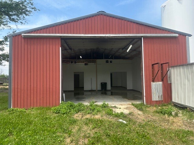
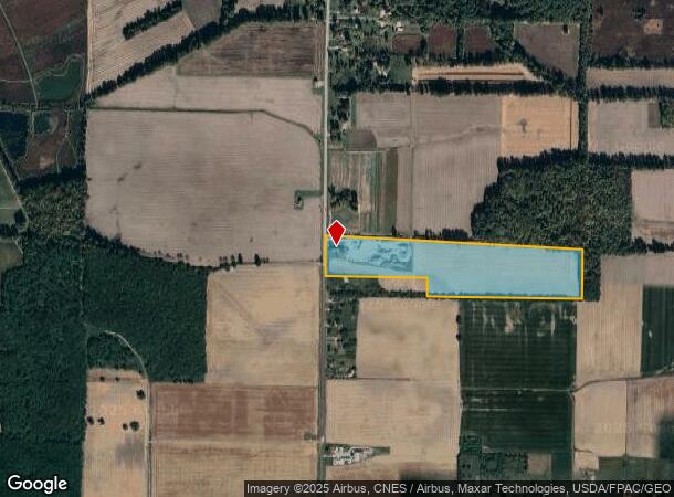
10835 Avon Belden Rd
11-00-048-000-026
Merger
Agriculturalland
MERGER 12/1/09 20090318311 33.64 AC
X
Lorain
39093C0234D
Ohio
2024
33.64 AC
2024
Outlying Lorain
091100
Cleveland
2,864 SF
Cleveland-Elyria, OH
DEMOGRAPHICS near 10835 Avon Belden Rd
1 Mile
3 Mile
5 Mile
2024 Total Population
273
18,304
81,464
2029 Population
286
19,091
84,121
Pop Growth 2024-2029
+ 4.76%
+ 4.30%
+ 3.26%
Average Age
46
44
42
2024 Total Households
110
7,257
32,212
HH Growth 2024-2029
+ 5.45%
+ 4.35%
+ 3.34%
Median Household Inc
$71,999
$83,465
$69,602
Avg Household Size
2.50
2.40
2.40
2024 Avg HH Vehicles
2.00
2.00
2.00
Median Home Value
$191,999
$226,148
$187,521
Median Year Built
1962
1998
1975
Nearby Places
Map Layers
Map Styles
 Street
 Aerial
- Restaurants
- Banks
- Shops
- Fitness
- Groceries
PUBLIC TRANSPORTATION
COMMUTER RAIL
Elyria Amtrak (Capitol Limited - Amtrak, Lake Shore Limited - Amtrak)
DRIVE
WALK
Distance
Elyria Amtrak (Capitol Limited - Amtrak, Lake Shore Limited - Amtrak)
12 min
7.8 mi
AIRPORT
Cleveland-Hopkins International
DRIVE
WALK
Distance
Cleveland-Hopkins International
21 min
13.7 mi
Freight Ports
Port of Toledo
DRIVE
WALK
Distance
Port of Toledo
119 min
98.1 mi
SALE & LEASE HISTORY
LISTING DATE
SALE/LEASE

Jul 01, 2024
For Lease
Nearby Properties
Address
Land Use
TOTAL SIZE
Lot Size
Zoning
Address
Land Use
TOTAL SIZE
Lot Size
Zoning
107,576 SF
14.79 AC
Address
Land Use
TOTAL SIZE
Lot Size
Zoning
206,128 SF
19.97 AC
Address
Land Use
TOTAL SIZE
Lot Size
Zoning
40,000 SF
4.20 AC
Address
Land Use
TOTAL SIZE
Lot Size
Zoning
47,968 SF
5.40 AC
Address
Land Use
TOTAL SIZE
Lot Size
Zoning
47,700 SF
6.13 AC
Address
Land Use
TOTAL SIZE
Lot Size
Zoning
33,400 SF
13.90 AC
Address
Land Use
TOTAL SIZE
Lot Size
Zoning
39,212 SF
25 AC
Address
Land Use
TOTAL SIZE
Lot Size
Zoning
21,599 SF
1 AC
Address
Land Use
TOTAL SIZE
Lot Size
Zoning
8,526 SF
5.19 AC
Address
Land Use
TOTAL SIZE
Lot Size
Zoning
59,120 SF
80.37 AC
Address
Land Use
TOTAL SIZE
Lot Size
Zoning
10,370 SF
4.75 AC
Address
Land Use
TOTAL SIZE
Lot Size
Zoning
14,760 SF
3.14 AC
Address
Land Use
TOTAL SIZE
Lot Size
Zoning
99,880 SF
7.94 AC
Address
Land Use
TOTAL SIZE
Lot Size
Zoning
5,842 SF
3.15 AC
Address
Land Use
TOTAL SIZE
Lot Size
Zoning
11,000 SF
28.37 AC
Address
Land Use
TOTAL SIZE
Lot Size
Zoning
16,831 SF
8.40 AC
Address
Land Use
TOTAL SIZE
Lot Size
Zoning
26,048 SF
2.21 AC
Address
Land Use
TOTAL SIZE
Lot Size
Zoning
15,822 SF
20.01 AC
Address
Land Use
TOTAL SIZE
Lot Size
Zoning
18,072 SF
1.88 AC
Address
Land Use
TOTAL SIZE
Lot Size
Zoning
7,823 SF
2.36 AC
Address
Land Use
TOTAL SIZE
Lot Size
Zoning
124,109 SF
21.44 AC
Address
Land Use
TOTAL SIZE
Lot Size
Zoning
8,752 SF
1.92 AC
Address
Land Use
TOTAL SIZE
Lot Size
Zoning
9,764 SF
56.20 AC
Address
Land Use
TOTAL SIZE
Lot Size
Zoning
10,400 SF
0.25 AC
Address
Land Use
TOTAL SIZE
Lot Size
Zoning
64,180 SF
13.03 AC
Address
Land Use
TOTAL SIZE
Lot Size
Zoning
48,000 SF
6.32 AC
Address
Land Use
TOTAL SIZE
Lot Size
Zoning
79,543 SF
4.30 AC
Address
Land Use
TOTAL SIZE
Lot Size
Zoning
4,771 SF
1.44 AC
Address
Land Use
TOTAL SIZE
Lot Size
Zoning
2,380 SF
1.20 AC
Address
Land Use
TOTAL SIZE
Lot Size
Zoning
72,800 SF
5.35 AC
The World's #1 Commercial Real Estate Marketplace
Connect with us
© 2026 CoStar Group
The information above has been obtained from sources believed reliable. While we do not doubt its accuracy we have not verified it and make no guarantee, warranty or representation about it. It is your responsibility to independently confirm its accuracy and completeness. Any projections, opinions, assumptions, or estimates used are for example only and do not represent the current or future performance of the property. The value of this transaction to you depends on tax and other factors which should be evaluated by your tax, financial, and legal advisors. You and your advisors should conduct a careful, independent investigation of the property to determine to your satisfaction the suitability of the property for your needs.