Property Record
1084 Loganville Hwy, Bethlehem, GA 30620
NEARBY LISTINGS FOR SALE OR LEASE
Property Detail
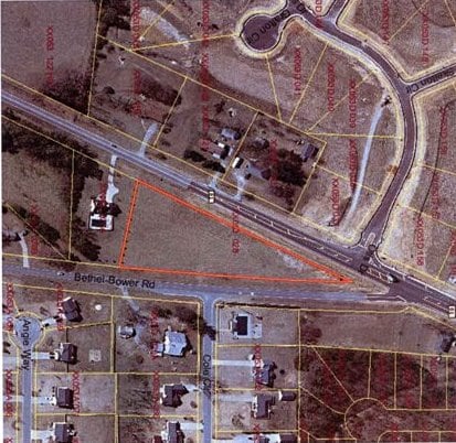
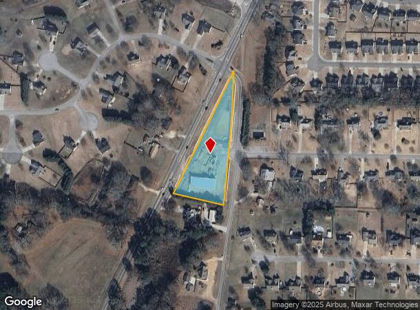
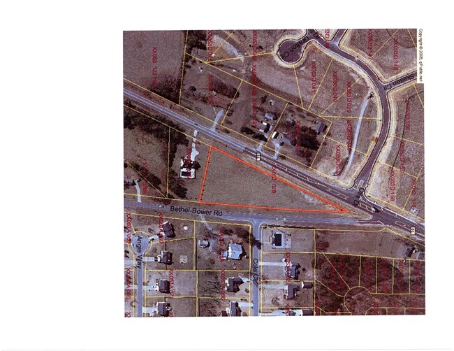
1084 Loganville Hwy
Atlanta-Sandy Springs-Roswell, GA
Jackson Park
XX053-028
BETHEL CHURCH RD & GA HWY 81
Commercialacreage
Barrow
X
Georgia
13297C0020F
2 AC
2024
Barrow County
2024
Atlanta
180503
DEMOGRAPHICS near 1084 Loganville Hwy
1 Mile
3 Mile
5 Mile
2024 Total Population
4,109
19,934
43,074
2029 Population
4,832
23,144
49,614
Pop Growth 2024-2029
+ 17.60%
+ 16.10%
+ 15.18%
Average Age
34
35
37
2024 Total Households
1,319
6,468
14,281
HH Growth 2024-2029
+ 17.74%
+ 16.23%
+ 15.45%
Median Household Inc
$65,903
$71,722
$71,258
Avg Household Size
3.00
3.00
3.00
2024 Avg HH Vehicles
2.00
2.00
2.00
Median Home Value
$214,881
$222,602
$231,330
Median Year Built
2004
2003
2000
Nearby Places
Map Layers
Map Styles
 Street
 Aerial
- Restaurants
- Banks
- Shops
- Fitness
- Groceries
SALE & LEASE HISTORY
LISTING DATE
SALE/LEASE

Sep 24, 2016
For Sale
Nearby Properties
Address
Land Use
TOTAL SIZE
Lot Size
Zoning
Address
Land Use
TOTAL SIZE
Lot Size
Zoning
10,128 SF
28.20 AC
R-3
Address
Land Use
TOTAL SIZE
Lot Size
Zoning
26,789 SF
35.60 AC
C-3
Address
Land Use
TOTAL SIZE
Lot Size
Zoning
22,320 SF
15.90 AC
R-3
Address
Land Use
TOTAL SIZE
Lot Size
Zoning
120,000 SF
142.70 AC
AG
Address
Land Use
TOTAL SIZE
Lot Size
Zoning
2,046 SF
13 AC
B-2,R-3
Address
Land Use
TOTAL SIZE
Lot Size
Zoning
167,580 SF
21.80 AC
M-2
Address
Land Use
TOTAL SIZE
Lot Size
Zoning
132,156 SF
10.10 AC
C-2
Address
Land Use
TOTAL SIZE
Lot Size
Zoning
79,029 SF
9.70 AC
C-2
Address
Land Use
TOTAL SIZE
Lot Size
Zoning
37,162 SF
4.60 AC
R-3
Address
Land Use
TOTAL SIZE
Lot Size
Zoning
104,805 SF
12.50 AC
C-3
Address
Land Use
TOTAL SIZE
Lot Size
Zoning
1,188 SF
7.60 AC
R-3
Address
Land Use
TOTAL SIZE
Lot Size
Zoning
60,540 SF
79.30 AC
AG
Address
Land Use
TOTAL SIZE
Lot Size
Zoning
38,550 SF
3 AC
C-2
Address
Land Use
TOTAL SIZE
Lot Size
Zoning
55,420 SF
5 AC
C-3
Address
Land Use
TOTAL SIZE
Lot Size
Zoning
26,802 SF
5 AC
AG
Address
Land Use
TOTAL SIZE
Lot Size
Zoning
24,982 SF
16.10 AC
R-1
Address
Land Use
TOTAL SIZE
Lot Size
Zoning
46,339 SF
2 AC
B-2
Address
Land Use
TOTAL SIZE
Lot Size
Zoning
76,768 SF
19 AC
AG
Address
Land Use
TOTAL SIZE
Lot Size
Zoning
45,296 SF
8.20 AC
B-2
Address
Land Use
TOTAL SIZE
Lot Size
Zoning
19,483 SF
2.80 AC
B-2
Address
Land Use
TOTAL SIZE
Lot Size
Zoning
64,800 SF
47.30 AC
M-1
Address
Land Use
TOTAL SIZE
Lot Size
Zoning
2,398 SF
8.10 AC
R-3
Address
Land Use
TOTAL SIZE
Lot Size
Zoning
49,920 SF
24.50 AC
AG
Address
Land Use
TOTAL SIZE
Lot Size
Zoning
18,240 SF
0.93 AC
B-2
Address
Land Use
TOTAL SIZE
Lot Size
Zoning
5,500 SF
12.90 AC
C-3
Address
Land Use
TOTAL SIZE
Lot Size
Zoning
14,300 SF
5.80 AC
M-1
Address
Land Use
TOTAL SIZE
Lot Size
Zoning
4,026 SF
1.60 AC
B-2
Address
Land Use
TOTAL SIZE
Lot Size
Zoning
14,356 SF
2.30 AC
B-2
Address
Land Use
TOTAL SIZE
Lot Size
Zoning
1,395 SF
0.16 AC
HPM2*
Address
Land Use
TOTAL SIZE
Lot Size
Zoning
51,896 SF
6.20 AC
M-1
The World's #1 Commercial Real Estate Marketplace
Connect with us
© 2025 CoStar Group
The information above has been obtained from sources believed reliable. While we do not doubt its accuracy we have not verified it and make no guarantee, warranty or representation about it. It is your responsibility to independently confirm its accuracy and completeness. Any projections, opinions, assumptions, or estimates used are for example only and do not represent the current or future performance of the property. The value of this transaction to you depends on tax and other factors which should be evaluated by your tax, financial, and legal advisors. You and your advisors should conduct a careful, independent investigation of the property to determine to your satisfaction the suitability of the property for your needs.