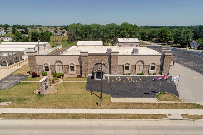
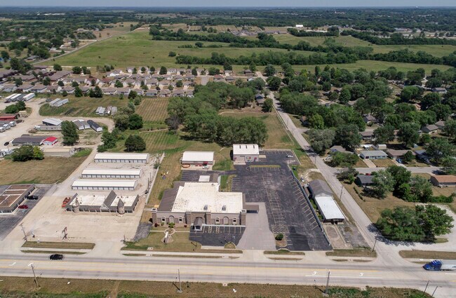
Property Record
2901 N State Route 291, Harrisonville, MO 64701

Property Detail
2901 N State Route 291
Kansas City, MO-KS
THUNDERBIRD PARK LOT 2 & BG NW CR LT2 N150 E852.71 S214.08 W95 S115 ETC
1768900
Cass
Religious
Missouri
B and X Area of moderate flood hazard, usually the area between the limits of the 100-year and 500-year floods.
2
0
6.49 AC
2025
Cass County
061400
Kansas City
16,060 SF
NEARBY LISTINGS FOR SALE OR LEASE
-
-
No Photo
-
View all Harrisonville listings for sale on LoopNet.com
DEMOGRAPHICS near 2901 N State Route 291
1 mile
3 mile
5 mile
2025 Total Population
858
11,206
14,567
2030 Population
881
11,621
15,115
Pop Growth 2025-2030
+ 2.68%
+ 3.70%
+ 3.76%
Average Age
45
41
41
2025 Total Households
371
4,382
5,632
HH Growth 2025-2030
+ 2.96%
+ 3.93%
+ 3.98%
Median Household Inc
$63,871
$71,504
$77,744
Avg Household Size
2.10
2.40
2.50
2025 Avg HH Vehicles
2.00
2.00
2.00
Median Home Value
$225,610
$247,378
$275,211
Median Year Built
1990
1976
1979
Nearby Places
Map Layers
Map Styles
 Street
 Aerial
Transit
 Traffic
 Biking
Places
Listings with unknown addresses are not visible on the map
- Restaurants
- Banks
- Shops
- Fitness
- Groceries
SALE & LEASE HISTORY
LISTING DATE
SALE/LEASE

May 04, 2024
For Sale
Nearby Properties
Address
Land Use
TOTAL SIZE
Lot Size
Zoning
Address
Land Use
TOTAL SIZE
Lot Size
Zoning
197,883 SF
30 AC
Address
Land Use
TOTAL SIZE
Lot Size
Zoning
1,030,621 SF
43.38 AC
Address
Land Use
TOTAL SIZE
Lot Size
Zoning
411,232 SF
26.77 AC
Address
Land Use
TOTAL SIZE
Lot Size
Zoning
157,628 SF
5.06 AC
Address
Land Use
TOTAL SIZE
Lot Size
Zoning
55,413 SF
8 AC
Address
Land Use
TOTAL SIZE
Lot Size
Zoning
1,126,810 SF
17.17 AC
Address
Land Use
TOTAL SIZE
Lot Size
Zoning
Address
Land Use
TOTAL SIZE
Lot Size
Zoning
15,840 SF
20 AC
Address
Land Use
TOTAL SIZE
Lot Size
Zoning
105,500 SF
4.29 AC
Address
Land Use
TOTAL SIZE
Lot Size
Zoning
103,920 SF
12.29 AC
Address
Land Use
TOTAL SIZE
Lot Size
Zoning
53,673 SF
12.16 AC
Address
Land Use
TOTAL SIZE
Lot Size
Zoning
65,356 SF
6.21 AC
Address
Land Use
TOTAL SIZE
Lot Size
Zoning
40,784 SF
0.45 AC
Address
Land Use
TOTAL SIZE
Lot Size
Zoning
3,040 SF
5 AC
Address
Land Use
TOTAL SIZE
Lot Size
Zoning
408,200 SF
10 AC
Address
Land Use
TOTAL SIZE
Lot Size
Zoning
460,328 SF
20 AC
Address
Land Use
TOTAL SIZE
Lot Size
Zoning
45,480 SF
6.46 AC
Address
Land Use
TOTAL SIZE
Lot Size
Zoning
62,008 SF
4.97 AC
Address
Land Use
TOTAL SIZE
Lot Size
Zoning
74,086 SF
5.39 AC
Address
Land Use
TOTAL SIZE
Lot Size
Zoning
88,957 SF
9.93 AC
Address
Land Use
TOTAL SIZE
Lot Size
Zoning
21,310 SF
3.40 AC
Address
Land Use
TOTAL SIZE
Lot Size
Zoning
20,600 SF
3.90 AC
Address
Land Use
TOTAL SIZE
Lot Size
Zoning
55,428 SF
10 AC
Address
Land Use
TOTAL SIZE
Lot Size
Zoning
48.57 AC
Address
Land Use
TOTAL SIZE
Lot Size
Zoning
107,500 SF
7.10 AC
Address
Land Use
TOTAL SIZE
Lot Size
Zoning
45,944 SF
7 AC
Address
Land Use
TOTAL SIZE
Lot Size
Zoning
Address
Land Use
TOTAL SIZE
Lot Size
Zoning
7,540 SF
0.82 AC
Address
Land Use
TOTAL SIZE
Lot Size
Zoning
17,589 SF
4.50 AC
The World's #1 Commercial Real Estate Marketplace
Connect with us
© 2026 CoStar Group
The information above has been obtained from sources believed reliable. While we do not doubt its accuracy we have not verified it and make no guarantee, warranty or representation about it. It is your responsibility to independently confirm its accuracy and completeness. Any projections, opinions, assumptions, or estimates used are for example only and do not represent the current or future performance of the property. The value of this transaction to you depends on tax and other factors which should be evaluated by your tax, financial, and legal advisors. You and your advisors should conduct a careful, independent investigation of the property to determine to your satisfaction the suitability of the property for your needs.