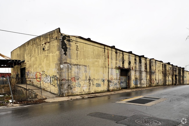
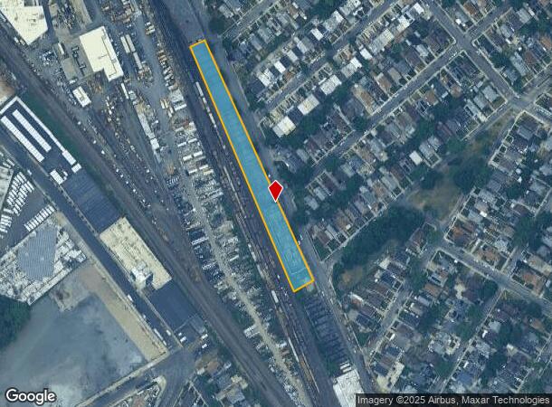
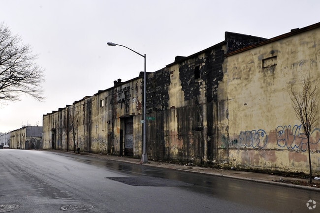
Property Record
10840 Dunkirk St, Saint Albans, NY 11412
NEARBY LISTINGS FOR SALE OR LEASE
Property Detail
10840 Dunkirk St
10343-0165
Queens
Warehouse
New York
X
165
3604970234F
1.15 AC
2024
South Queens
2025
Long Island (New York)
044400
New York-Jersey City-White Plains, NY-NJ
38,500 SF
DEMOGRAPHICS near 10840 Dunkirk St
1 mile
3 mile
5 mile
2024 Total Population
63,526
564,261
1,268,216
2029 Population
58,346
524,048
1,185,522
Pop Growth 2024-2029
(8.15%)
(7.13%)
(6.52%)
Average Age
41
41
42
2024 Total Households
18,821
178,980
422,664
HH Growth 2024-2029
(8.63%)
(7.38%)
(6.70%)
Median Household Inc
$72,498
$76,370
$80,877
Avg Household Size
3.20
3.00
2.90
2024 Avg HH Vehicles
1.00
1.00
1.00
Median Home Value
$643,856
$634,601
$659,987
Median Year Built
1949
1951
1952
Nearby Places
Map Layers
Map Styles
 Street
 Aerial
Transit
 Traffic
 Biking
Places
Listings with unknown addresses are not visible on the map
- Restaurants
- Banks
- Shops
- Fitness
- Groceries
PUBLIC TRANSPORTATION
COMMUTER RAIL
Hillside Facility (Hempstead Branch - Long Island Rail Road, Montauk Branch - Long Island Rail Road, Oyster Bay Branch - Long Island Rail Road, Port Jefferson Branch - Long Island Rail Road, Ronkonkoma Branch - Long Island Rail Road)
Drive
Walk
Distance
Hillside Facility (Hempstead Branch - Long Island Rail Road, Montauk Branch - Long Island Rail Road, Oyster Bay Branch - Long Island Rail Road, Port Jefferson Branch - Long Island Rail Road, Ronkonkoma Branch - Long Island Rail Road)
1 min
10 min
0.5 mi
Hollis Station (Hempstead Branch - Long Island Rail Road)
Drive
Walk
Distance
Hollis Station (Hempstead Branch - Long Island Rail Road)
3 min
20 min
0.9 mi
AIRPORT
John F Kennedy International
Drive
Walk
Distance
John F Kennedy International
11 min
7.3 mi
LaGuardia
Drive
Walk
Distance
LaGuardia
17 min
9.6 mi
Newark Liberty International
Drive
Walk
Distance
Newark Liberty International
43 min
29.4 mi
Freight Ports
NY - Red Hook Container Terminal
Drive
Walk
Distance
NY - Red Hook Container Terminal
29 min
18.1 mi
SALE & LEASE HISTORY
LISTING DATE
SALE/LEASE

Dec 05, 2016
For Lease
Nearby Properties
Address
Land Use
TOTAL SIZE
Lot Size
Zoning
Address
Land Use
TOTAL SIZE
Lot Size
Zoning
107.28 AC
R6
Address
Land Use
TOTAL SIZE
Lot Size
Zoning
107.28 AC
R6
Address
Land Use
TOTAL SIZE
Lot Size
Zoning
107.28 AC
R6
Address
Land Use
TOTAL SIZE
Lot Size
Zoning
4,528,000 SF
94.27 AC
R4
Address
Land Use
TOTAL SIZE
Lot Size
Zoning
6,940,450 SF
107.28 AC
R6
Address
Land Use
TOTAL SIZE
Lot Size
Zoning
1,069,367 SF
14.65 AC
R4
Address
Land Use
TOTAL SIZE
Lot Size
Zoning
532,011 SF
2.48 AC
R6
Address
Land Use
TOTAL SIZE
Lot Size
Zoning
13,500 SF
104 AC
PARK
Address
Land Use
TOTAL SIZE
Lot Size
Zoning
731,247 SF
56.09 AC
R3-2
Address
Land Use
TOTAL SIZE
Lot Size
Zoning
947 SF
101.82 AC
PARK
Address
Land Use
TOTAL SIZE
Lot Size
Zoning
749,142 SF
16.48 AC
R6
Address
Land Use
TOTAL SIZE
Lot Size
Zoning
749,142 SF
16.48 AC
R6
Address
Land Use
TOTAL SIZE
Lot Size
Zoning
749,142 SF
16.48 AC
R6
Address
Land Use
TOTAL SIZE
Lot Size
Zoning
749,142 SF
16.48 AC
R6
Address
Land Use
TOTAL SIZE
Lot Size
Zoning
749,142 SF
16.48 AC
R6
Address
Land Use
TOTAL SIZE
Lot Size
Zoning
749,142 SF
16.48 AC
R6
Address
Land Use
TOTAL SIZE
Lot Size
Zoning
749,142 SF
16.48 AC
R6
Address
Land Use
TOTAL SIZE
Lot Size
Zoning
1,186,778 SF
31.45 AC
R4
Address
Land Use
TOTAL SIZE
Lot Size
Zoning
644,836 SF
14.26 AC
R5
Address
Land Use
TOTAL SIZE
Lot Size
Zoning
644,836 SF
14.26 AC
R5
Address
Land Use
TOTAL SIZE
Lot Size
Zoning
644,836 SF
14.26 AC
R5
Address
Land Use
TOTAL SIZE
Lot Size
Zoning
644,836 SF
14.26 AC
R5
Address
Land Use
TOTAL SIZE
Lot Size
Zoning
644,836 SF
14.26 AC
R5
Address
Land Use
TOTAL SIZE
Lot Size
Zoning
644,836 SF
14.26 AC
R5
Address
Land Use
TOTAL SIZE
Lot Size
Zoning
644,836 SF
14.26 AC
R5
Address
Land Use
TOTAL SIZE
Lot Size
Zoning
644,836 SF
14.26 AC
R5
Address
Land Use
TOTAL SIZE
Lot Size
Zoning
644,836 SF
14.26 AC
R5
Address
Land Use
TOTAL SIZE
Lot Size
Zoning
644,836 SF
14.26 AC
R5
Address
Land Use
TOTAL SIZE
Lot Size
Zoning
644,836 SF
14.26 AC
R5
Address
Land Use
TOTAL SIZE
Lot Size
Zoning
644,836 SF
14.26 AC
R5
The World's #1 Commercial Real Estate Marketplace
Connect with us
© 2026 CoStar Group
The information above has been obtained from sources believed reliable. While we do not doubt its accuracy we have not verified it and make no guarantee, warranty or representation about it. It is your responsibility to independently confirm its accuracy and completeness. Any projections, opinions, assumptions, or estimates used are for example only and do not represent the current or future performance of the property. The value of this transaction to you depends on tax and other factors which should be evaluated by your tax, financial, and legal advisors. You and your advisors should conduct a careful, independent investigation of the property to determine to your satisfaction the suitability of the property for your needs.