Property Record
1085 State Route 196, Hudson Falls, NY 12839
NEARBY LISTINGS FOR SALE OR LEASE
-
-
View all Hudson Falls listings for sale on LoopNet.com
Property Detail
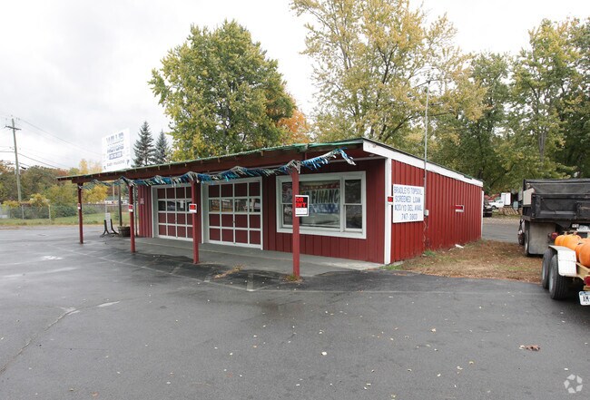
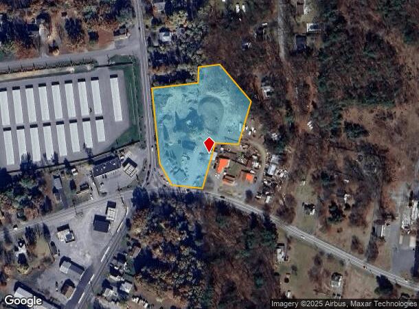
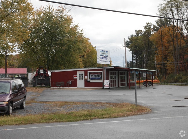
1085 State Route 196
Glens Falls, NY
RES/LAND/FRUIT STND
534489-154-012-0001-007-000-0000
Washington
Commercialofficeresidentialmixeduse
New York
2025
7.000
2024
3.10 AC
080301
Washington County
1,040 SF
Albany/Schenectady/Troy
DEMOGRAPHICS near 1085 State Route 196
1 Mile
3 Mile
5 Mile
2024 Total Population
3,424
16,388
42,107
2029 Population
3,376
16,177
41,792
Pop Growth 2024-2029
(1.40%)
(1.29%)
(0.75%)
Average Age
41
41
42
2024 Total Households
1,424
6,923
18,465
HH Growth 2024-2029
(1.47%)
(1.36%)
(0.82%)
Median Household Inc
$60,688
$58,319
$61,176
Avg Household Size
2.30
2.30
2.20
2024 Avg HH Vehicles
1.00
2.00
2.00
Median Home Value
$158,420
$153,312
$168,096
Median Year Built
1958
1956
1955
Nearby Places
Map Layers
Map Styles
 Street
 Aerial
- Restaurants
- Banks
- Shops
- Fitness
- Groceries
PUBLIC TRANSPORTATION
COMMUTER RAIL
Fort Edward Amtrak (Adirondack - Amtrak, Ethan Allen Express - Amtrak)
DRIVE
WALK
Distance
Fort Edward Amtrak (Adirondack - Amtrak, Ethan Allen Express - Amtrak)
8 min
3.0 mi
Freight Ports
Albany, NY Port
DRIVE
WALK
Distance
Albany, NY Port
78 min
57.5 mi
Nearby Properties
Address
Land Use
TOTAL SIZE
Lot Size
Zoning
Address
Land Use
TOTAL SIZE
Lot Size
Zoning
16.34 AC
M1
Address
Land Use
TOTAL SIZE
Lot Size
Zoning
116,696 SF
23.70 AC
04 - FARM
Address
Land Use
TOTAL SIZE
Lot Size
Zoning
393,880 SF
23.90 AC
M1
Address
Land Use
TOTAL SIZE
Lot Size
Zoning
9,216 SF
32.20 AC
UR
Address
Land Use
TOTAL SIZE
Lot Size
Zoning
82,922 SF
8.03 AC
I
Address
Land Use
TOTAL SIZE
Lot Size
Zoning
113.40 AC
04 - FARM
Address
Land Use
TOTAL SIZE
Lot Size
Zoning
7,823 SF
27.33 AC
LDR25
Address
Land Use
TOTAL SIZE
Lot Size
Zoning
6,549 SF
17.26 AC
M1
Address
Land Use
TOTAL SIZE
Lot Size
Zoning
156,550 SF
33.27 AC
CI
Address
Land Use
TOTAL SIZE
Lot Size
Zoning
7,788 SF
25.34 AC
LDR25
Address
Land Use
TOTAL SIZE
Lot Size
Zoning
20,250 SF
46.97 AC
HI
Address
Land Use
TOTAL SIZE
Lot Size
Zoning
18,133 SF
29.71 AC
LDR25
Address
Land Use
TOTAL SIZE
Lot Size
Zoning
53,216 SF
14.20 AC
CLI
Address
Land Use
TOTAL SIZE
Lot Size
Zoning
3,000 SF
14.95 AC
M1
Address
Land Use
TOTAL SIZE
Lot Size
Zoning
176,238 SF
28.98 AC
CLI
Address
Land Use
TOTAL SIZE
Lot Size
Zoning
134,998 SF
20.10 AC
05 - COMME
Address
Land Use
TOTAL SIZE
Lot Size
Zoning
119,455 SF
66.60 AC
LDR25
Address
Land Use
TOTAL SIZE
Lot Size
Zoning
42,156 SF
5.93 AC
05 - COMME
Address
Land Use
TOTAL SIZE
Lot Size
Zoning
141,480 SF
29.05 AC
RA
Address
Land Use
TOTAL SIZE
Lot Size
Zoning
60,000 SF
15.96 AC
CLI
Address
Land Use
TOTAL SIZE
Lot Size
Zoning
41,280 SF
50.96 AC
M1
Address
Land Use
TOTAL SIZE
Lot Size
Zoning
106,209 SF
6.22 AC
M1
Address
Land Use
TOTAL SIZE
Lot Size
Zoning
2,400 SF
27.88 AC
M1
Address
Land Use
TOTAL SIZE
Lot Size
Zoning
33,270 SF
68.64 AC
RA1A
Address
Land Use
TOTAL SIZE
Lot Size
Zoning
600 SF
62.72 AC
HI
Address
Land Use
TOTAL SIZE
Lot Size
Zoning
75,156 SF
2.78 AC
RA
Address
Land Use
TOTAL SIZE
Lot Size
Zoning
36,249 SF
5.40 AC
COM1A
Address
Land Use
TOTAL SIZE
Lot Size
Zoning
4,200 SF
10.74 AC
LDR25
Address
Land Use
TOTAL SIZE
Lot Size
Zoning
131,704 SF
3.19 AC
M1
Address
Land Use
TOTAL SIZE
Lot Size
Zoning
136,449 SF
14.92 AC
LDR25
The World's #1 Commercial Real Estate Marketplace
Connect with us
© 2026 CoStar Group
The information above has been obtained from sources believed reliable. While we do not doubt its accuracy we have not verified it and make no guarantee, warranty or representation about it. It is your responsibility to independently confirm its accuracy and completeness. Any projections, opinions, assumptions, or estimates used are for example only and do not represent the current or future performance of the property. The value of this transaction to you depends on tax and other factors which should be evaluated by your tax, financial, and legal advisors. You and your advisors should conduct a careful, independent investigation of the property to determine to your satisfaction the suitability of the property for your needs.