Property Record
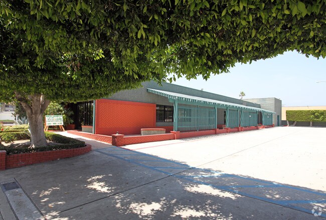
1085 W Badillo St, Covina, CA 91722


Property Detail
1085 W Badillo St
8434-018-021
PHILLIPS TRACT RANCHO LA PUENTE LOT COM N ON W LINE OF LOT 2 BLK 5,21 FT FROM SW COR OF SD LOT TH E ON N LINE OF BADILLO ST 100 FT WITH A UNIFORM DEPTH OF 150 FT N 0 34 E PART OF LOT 2 BLK 5
Officebuilding
Los Angeles
CVC3AY
California
B and X Area of moderate flood hazard, usually the area between the limits of the 100-year and 500-year floods.
2
2024
0.34 AC
2025
Eastern SGV
405702
Los Angeles
4,175 SF
Los Angeles-Long Beach-Glendale, CA
NEARBY LISTINGS FOR SALE OR LEASE
DEMOGRAPHICS near 1085 W Badillo St
1 mile
3 mile
5 mile
2025 Total Population
25,632
196,005
454,011
2030 Population
25,394
193,462
448,161
Pop Growth 2025-2030
(0.93%)
(1.30%)
(1.29%)
Average Age
41
40
40
2025 Total Households
7,842
57,246
131,261
HH Growth 2025-2030
(1.17%)
(1.50%)
(1.46%)
Median Household Inc
$89,687
$92,962
$95,094
Avg Household Size
3.20
3.30
3.30
2025 Avg HH Vehicles
2.00
2.00
2.00
Median Home Value
$721,897
$727,944
$730,609
Median Year Built
1958
1958
1963
Nearby Places
Map Layers
Map Styles
 Street
 Aerial
Layers
 Traffic
 Biking
Places
Listings with unknown addresses are not visible on the map
- Restaurants
- Banks
- Shops
- Fitness
- Groceries
PUBLIC TRANSPORTATION
COMMUTER RAIL
Covina (San Bernardino Line - Southern California Regional Rail Authority (Metrolink))
Drive
Walk
Distance
Covina (San Bernardino Line - Southern California Regional Rail Authority (Metrolink))
4 min
1.8 mi
Baldwin Park (San Bernardino Line - Southern California Regional Rail Authority (Metrolink))
Drive
Walk
Distance
Baldwin Park (San Bernardino Line - Southern California Regional Rail Authority (Metrolink))
4 min
2.7 mi
AIRPORT
Ontario International
Drive
Walk
Distance
Ontario International
27 min
20.7 mi
Long Beach (Daugherty Field)
Drive
Walk
Distance
Long Beach (Daugherty Field)
39 min
29.5 mi
Bob Hope
Drive
Walk
Distance
Bob Hope
44 min
33.6 mi
Freight Ports
Port of Long Beach
Drive
Walk
Distance
Port of Long Beach
45 min
35.2 mi
Nearby Properties
Address
Land Use
TOTAL SIZE
Lot Size
Zoning
Address
Land Use
TOTAL SIZE
Lot Size
Zoning
702,934 SF
16.81 AC
WCCR
Address
Land Use
TOTAL SIZE
Lot Size
Zoning
546,676 SF
6.38 AC
WCCR*
Address
Land Use
TOTAL SIZE
Lot Size
Zoning
286,646 SF
21.99 AC
WCOPCC*
Address
Land Use
TOTAL SIZE
Lot Size
Zoning
83,337 SF
38.49 AC
WCCR*
Address
Land Use
TOTAL SIZE
Lot Size
Zoning
190,824 SF
8.21 AC
WCR3-MF20*
Address
Land Use
TOTAL SIZE
Lot Size
Zoning
1,104,998 SF
28 AC
IRM2*
Address
Land Use
TOTAL SIZE
Lot Size
Zoning
748,778 SF
11.48 AC
CVC3A*
Address
Land Use
TOTAL SIZE
Lot Size
Zoning
184,820 SF
IRM1*
Address
Land Use
TOTAL SIZE
Lot Size
Zoning
862,213 SF
21.22 AC
WCSP
Address
Land Use
TOTAL SIZE
Lot Size
Zoning
627,908 SF
23.08 AC
IRM1*
Address
Land Use
TOTAL SIZE
Lot Size
Zoning
270,111 SF
12.79 AC
IRM2*
Address
Land Use
TOTAL SIZE
Lot Size
Zoning
119,669 SF
1.56 AC
WCCR*
Address
Land Use
TOTAL SIZE
Lot Size
Zoning
63,919 SF
2.97 AC
CVCP*
Address
Land Use
TOTAL SIZE
Lot Size
Zoning
154,820 SF
3.68 AC
WCRA
Address
Land Use
TOTAL SIZE
Lot Size
Zoning
459,461 SF
1.40 AC
WCCR*
Address
Land Use
TOTAL SIZE
Lot Size
Zoning
294,391 SF
16.90 AC
WCC5*
Address
Land Use
TOTAL SIZE
Lot Size
Zoning
73,908 SF
7.70 AC
IRM1*
Address
Land Use
TOTAL SIZE
Lot Size
Zoning
108,544 SF
6.24 AC
LCC4*
Address
Land Use
TOTAL SIZE
Lot Size
Zoning
104,253 SF
2.88 AC
CVRD2000*
Address
Land Use
TOTAL SIZE
Lot Size
Zoning
120,588 SF
4.50 AC
WCR3-MF20*
Address
Land Use
TOTAL SIZE
Lot Size
Zoning
184,800 SF
4.73 AC
CVTCP*
Address
Land Use
TOTAL SIZE
Lot Size
Zoning
105,936 SF
5.24 AC
WCR3-MF20*
Address
Land Use
TOTAL SIZE
Lot Size
Zoning
195,586 SF
2.58 AC
WCCR*
Address
Land Use
TOTAL SIZE
Lot Size
Zoning
213,749 SF
4.99 AC
IRM2
Address
Land Use
TOTAL SIZE
Lot Size
Zoning
109,333 SF
4.30 AC
WCR3-MF20*
Address
Land Use
TOTAL SIZE
Lot Size
Zoning
315,543 SF
9.03 AC
WCNC*
Address
Land Use
TOTAL SIZE
Lot Size
Zoning
155,907 SF
4.38 AC
CVR3-RD150
Address
Land Use
TOTAL SIZE
Lot Size
Zoning
163,472 SF
8.40 AC
WCR3-MF20*
Address
Land Use
TOTAL SIZE
Lot Size
Zoning
147,852 SF
5.29 AC
AZM2YY
Address
Land Use
TOTAL SIZE
Lot Size
Zoning
141,174 SF
7.18 AC
WCR3-MF20*
The World's #1 Commercial Real Estate Marketplace
Connect with us
© 2026 CoStar Group
The information above has been obtained from sources believed reliable. While we do not doubt its accuracy we have not verified it and make no guarantee, warranty or representation about it. It is your responsibility to independently confirm its accuracy and completeness. Any projections, opinions, assumptions, or estimates used are for example only and do not represent the current or future performance of the property. The value of this transaction to you depends on tax and other factors which should be evaluated by your tax, financial, and legal advisors. You and your advisors should conduct a careful, independent investigation of the property to determine to your satisfaction the suitability of the property for your needs.