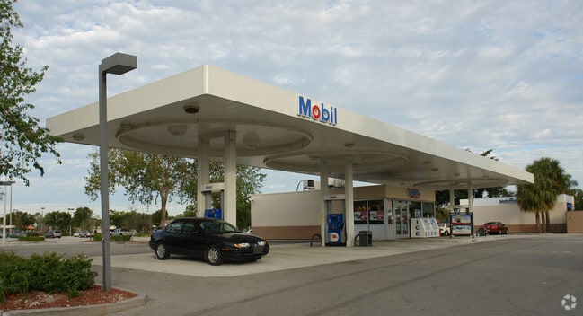
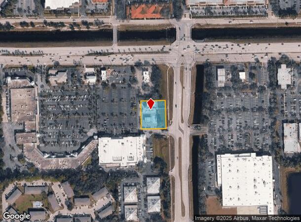
Property Record
10861 Airport Rd N, Naples, FL 34109
NEARBY LISTINGS FOR SALE OR LEASE
Property Detail
10861 Airport Rd N
00167480000
Acreage Header
Servicestation
26 48 25 COMM AT INTERSECTION S R/W LINE S/R 846 & W R/W LINE AIRPORT RD S 315FT, S 89 DEG W 25FT, POB S 89 DEG W 175FT, S 200 FT, N 89 DEG E 175FT, N 200FT POB OR 1091 PG 549
X
Collier
12021C0194J
Florida
2024
0.80 AC
2025
North Naples
010213
Southwest Florida
3,228 SF
Naples-Immokalee-Marco Island, FL
DEMOGRAPHICS near 10861 Airport Rd N
1 Mile
3 Mile
5 Mile
2024 Total Population
9,753
53,202
135,726
2029 Population
10,969
60,235
155,671
Pop Growth 2024-2029
+ 12.47%
+ 13.22%
+ 14.70%
Average Age
48
51
51
2024 Total Households
4,135
24,427
61,619
HH Growth 2024-2029
+ 12.14%
+ 12.85%
+ 14.38%
Median Household Inc
$74,672
$78,663
$84,877
Avg Household Size
2.20
2.10
2.10
2024 Avg HH Vehicles
2.00
2.00
2.00
Median Home Value
$424,191
$459,814
$491,114
Median Year Built
1993
1995
1996
Nearby Places
Map Layers
Map Styles
 Street
 Aerial
- Restaurants
- Banks
- Shops
- Fitness
- Groceries
PUBLIC TRANSPORTATION
AIRPORT
Southwest Florida International
DRIVE
WALK
Distance
Southwest Florida International
33 min
24.9 mi
Freight Ports
Port Everglades
DRIVE
WALK
Distance
Port Everglades
125 min
111.6 mi
Nearby Properties
Address
Land Use
TOTAL SIZE
Lot Size
Zoning
Address
Land Use
TOTAL SIZE
Lot Size
Zoning
688,632 SF
29.28 AC
A
Address
Land Use
TOTAL SIZE
Lot Size
Zoning
735,070 SF
41.34 AC
A
Address
Land Use
TOTAL SIZE
Lot Size
Zoning
377,883 SF
20.34 AC
PUD
Address
Land Use
TOTAL SIZE
Lot Size
Zoning
906,730 SF
7.86 AC
Address
Land Use
TOTAL SIZE
Lot Size
Zoning
313,544 SF
60 AC
A
Address
Land Use
TOTAL SIZE
Lot Size
Zoning
325,993 SF
35.92 AC
A
Address
Land Use
TOTAL SIZE
Lot Size
Zoning
398,094 SF
17.31 AC
A
Address
Land Use
TOTAL SIZE
Lot Size
Zoning
216,788 SF
85.21 AC
PUD
Address
Land Use
TOTAL SIZE
Lot Size
Zoning
110,908 SF
210.45 AC
A
Address
Land Use
TOTAL SIZE
Lot Size
Zoning
413,313 SF
48.48 AC
PUD
Address
Land Use
TOTAL SIZE
Lot Size
Zoning
353,756 SF
23.26 AC
ROAD
Address
Land Use
TOTAL SIZE
Lot Size
Zoning
292,967 SF
13.12 AC
PUD
Address
Land Use
TOTAL SIZE
Lot Size
Zoning
426,074 SF
23.25 AC
PUD
Address
Land Use
TOTAL SIZE
Lot Size
Zoning
252,506 SF
36.27 AC
PUD
Address
Land Use
TOTAL SIZE
Lot Size
Zoning
87,499 SF
4.36 AC
Address
Land Use
TOTAL SIZE
Lot Size
Zoning
174,770 SF
3.65 AC
PUD
Address
Land Use
TOTAL SIZE
Lot Size
Zoning
363,194 SF
2.51 AC
A
Address
Land Use
TOTAL SIZE
Lot Size
Zoning
181,774 SF
6.19 AC
PUD
Address
Land Use
TOTAL SIZE
Lot Size
Zoning
155,918 SF
27.31 AC
PUD
Address
Land Use
TOTAL SIZE
Lot Size
Zoning
192,347 SF
7.84 AC
PUD
Address
Land Use
TOTAL SIZE
Lot Size
Zoning
174,365 SF
18.56 AC
PUD
Address
Land Use
TOTAL SIZE
Lot Size
Zoning
188,741 SF
9.04 AC
A
Address
Land Use
TOTAL SIZE
Lot Size
Zoning
206,687 SF
19.85 AC
PUD
Address
Land Use
TOTAL SIZE
Lot Size
Zoning
128,681 SF
49.55 AC
A
Address
Land Use
TOTAL SIZE
Lot Size
Zoning
253,108 SF
32.47 AC
PUD
Address
Land Use
TOTAL SIZE
Lot Size
Zoning
230,920 SF
7.80 AC
C-4
Address
Land Use
TOTAL SIZE
Lot Size
Zoning
223,844 SF
27.55 AC
PUD
Address
Land Use
TOTAL SIZE
Lot Size
Zoning
112,623 SF
13.10 AC
PUD
Address
Land Use
TOTAL SIZE
Lot Size
Zoning
329,031 SF
20 AC
A
Address
Land Use
TOTAL SIZE
Lot Size
Zoning
161,531 SF
18.72 AC
PUD
The World's #1 Commercial Real Estate Marketplace
Connect with us
© 2025 CoStar Group
The information above has been obtained from sources believed reliable. While we do not doubt its accuracy we have not verified it and make no guarantee, warranty or representation about it. It is your responsibility to independently confirm its accuracy and completeness. Any projections, opinions, assumptions, or estimates used are for example only and do not represent the current or future performance of the property. The value of this transaction to you depends on tax and other factors which should be evaluated by your tax, financial, and legal advisors. You and your advisors should conduct a careful, independent investigation of the property to determine to your satisfaction the suitability of the property for your needs.