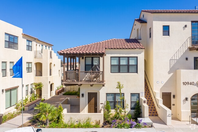
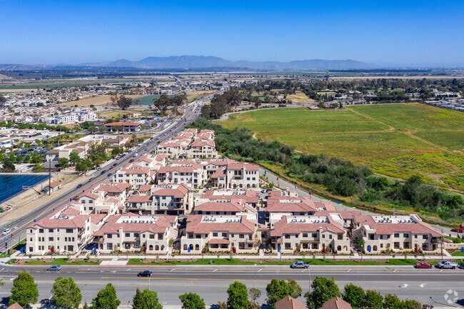
Property Record
10896 Telegraph Rd, Ventura, CA 93004
Save to a Folder
{{folder.Name}}
{{folder.ListingIds.length}} Properties
{{folder.ListingIds.length}} Property
Create a New Folder
Property Detail
10896 Telegraph Rd
Oxnard-Thousand Oaks-Ventura, CA
TRACT: 563201 LOT: 244 REF: 163MR 82
089-0-230-025
VENTURA
Apartment
California
AE The base floodplain where base flood elevations are provided. AE Zones are now used on new format FIRMs instead of A1-A30 Zones.
244
2025
1.52 AC
2026
Ventura
001304
Los Angeles
NEARBY LISTINGS FOR SALE OR LEASE
-
-
View all Ventura listings for sale on LoopNet.com
DEMOGRAPHICS near 10896 Telegraph Rd
1 mile
3 mile
5 mile
2025 Total Population
10,267
42,293
107,602
2030 Population
10,397
42,290
107,335
Pop Growth 2025-2030
+ 1.27%
(0.01%)
(0.25%)
Average Age
41
42
41
2025 Total Households
3,719
15,219
37,217
HH Growth 2025-2030
+ 1.13%
(0.12%)
(0.31%)
Median Household Inc
$101,630
$117,595
$106,703
Avg Household Size
2.60
2.70
2.80
2025 Avg HH Vehicles
2.00
2.00
2.00
Median Home Value
$691,590
$764,423
$745,902
Median Year Built
1978
1978
1978
Nearby Places
Map Layers
Map Styles
 Street
 Aerial
Layers
 Traffic
 Biking
Places
Listings with unknown addresses are not visible on the map
- Restaurants
- Banks
- Shops
- Fitness
- Groceries
PUBLIC TRANSPORTATION
COMMUTER RAIL
East Ventura Metrolink Station (Metrolink Ventura County Line - Metrolink Trains)
Drive
Walk
Distance
East Ventura Metrolink Station (Metrolink Ventura County Line - Metrolink Trains)
9 min
5.7 mi
Oxnard (Ventura County Line - Southern California Regional Rail Authority (Metrolink))
Drive
Walk
Distance
Oxnard (Ventura County Line - Southern California Regional Rail Authority (Metrolink))
14 min
8.1 mi
Freight Ports
The Port of Hueneme
Drive
Walk
Distance
The Port of Hueneme
22 min
12.5 mi
Nearby Properties
Address
Land Use
TOTAL SIZE
Lot Size
Zoning
Address
Land Use
TOTAL SIZE
Lot Size
Zoning
205,396 SF
12.48 AC
Address
Land Use
TOTAL SIZE
Lot Size
Zoning
24,154 SF
12.67 AC
R3-1
Address
Land Use
TOTAL SIZE
Lot Size
Zoning
4.76 AC
Address
Land Use
TOTAL SIZE
Lot Size
Zoning
151,422 SF
6.67 AC
Address
Land Use
TOTAL SIZE
Lot Size
Zoning
4.41 AC
Address
Land Use
TOTAL SIZE
Lot Size
Zoning
102,046 SF
3.72 AC
Address
Land Use
TOTAL SIZE
Lot Size
Zoning
87,804 SF
6.68 AC
RPD-
Address
Land Use
TOTAL SIZE
Lot Size
Zoning
3,725 SF
429.19 AC
AE
Address
Land Use
TOTAL SIZE
Lot Size
Zoning
1.09 AC
Address
Land Use
TOTAL SIZE
Lot Size
Zoning
Address
Land Use
TOTAL SIZE
Lot Size
Zoning
664 SF
4.63 AC
Address
Land Use
TOTAL SIZE
Lot Size
Zoning
45,925 SF
1.68 AC
Address
Land Use
TOTAL SIZE
Lot Size
Zoning
64,976 SF
3 AC
R3-5D
Address
Land Use
TOTAL SIZE
Lot Size
Zoning
46,507 SF
1.02 AC
C1A
Address
Land Use
TOTAL SIZE
Lot Size
Zoning
53,658 SF
3.18 AC
RPD-1
Address
Land Use
TOTAL SIZE
Lot Size
Zoning
70,700 SF
3.53 AC
M2
Address
Land Use
TOTAL SIZE
Lot Size
Zoning
10,995 SF
17.26 AC
M2
Address
Land Use
TOTAL SIZE
Lot Size
Zoning
1.59 AC
POD
Address
Land Use
TOTAL SIZE
Lot Size
Zoning
34,819 SF
1.28 AC
R3-2
Address
Land Use
TOTAL SIZE
Lot Size
Zoning
3.89 AC
7
Address
Land Use
TOTAL SIZE
Lot Size
Zoning
2.88 AC
POD
Address
Land Use
TOTAL SIZE
Lot Size
Zoning
41,970 SF
1.04 AC
Address
Land Use
TOTAL SIZE
Lot Size
Zoning
153.13 AC
AE/MRP
Address
Land Use
TOTAL SIZE
Lot Size
Zoning
262,132 SF
6.28 AC
M1
Address
Land Use
TOTAL SIZE
Lot Size
Zoning
103,938 SF
4.78 AC
R3-3
Address
Land Use
TOTAL SIZE
Lot Size
Zoning
30,052 SF
6.55 AC
M2
The World's #1 Commercial Real Estate Marketplace
Connect with us
© 2026 CoStar Group
The information above has been obtained from sources believed reliable. While we do not doubt its accuracy we have not verified it and make no guarantee, warranty or representation about it. It is your responsibility to independently confirm its accuracy and completeness. Any projections, opinions, assumptions, or estimates used are for example only and do not represent the current or future performance of the property. The value of this transaction to you depends on tax and other factors which should be evaluated by your tax, financial, and legal advisors. You and your advisors should conduct a careful, independent investigation of the property to determine to your satisfaction the suitability of the property for your needs.