Property Record
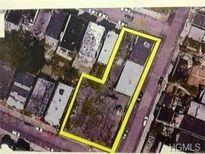
109 Maple St, Yonkers, NY 10701

NEARBY LISTINGS FOR SALE OR LEASE
Property Detail
109 Maple St
1800-001-000-00456-000-0029
Westchester
Commercialacreage
New York
X
29.000
34003C0220H
0.07 AC
2025
Southwest
2024
Westchester/So Connecticut
001101
New York-Jersey City-White Plains, NY-NJ
DEMOGRAPHICS near 109 Maple St
1 Mile
3 Mile
5 Mile
2024 Total Population
66,954
248,253
834,691
2029 Population
66,149
239,981
791,567
Pop Growth 2024-2029
(1.20%)
(3.33%)
(5.17%)
Average Age
37
40
40
2024 Total Households
23,953
95,587
308,086
HH Growth 2024-2029
(1.32%)
(3.51%)
(5.53%)
Median Household Inc
$40,447
$71,729
$66,208
Avg Household Size
2.60
2.50
2.60
2024 Avg HH Vehicles
1.00
1.00
1.00
Median Home Value
$382,208
$440,508
$551,487
Median Year Built
1962
1953
1951
Nearby Places
Map Layers
Map Styles
 Street
 Aerial
- Restaurants
- Banks
- Shops
- Fitness
- Groceries
SALE & LEASE HISTORY
LISTING DATE
SALE/LEASE

Oct 22, 2021
For Sale
Apr 10, 2025
For Sale
Nearby Properties
Address
Land Use
TOTAL SIZE
Lot Size
Zoning
Address
Land Use
TOTAL SIZE
Lot Size
Zoning
289.02 AC
P
Address
Land Use
TOTAL SIZE
Lot Size
Zoning
201,590 SF
4.13 AC
BA
Address
Land Use
TOTAL SIZE
Lot Size
Zoning
185.35 AC
P
Address
Land Use
TOTAL SIZE
Lot Size
Zoning
70,737 SF
1.67 AC
BB
Address
Land Use
TOTAL SIZE
Lot Size
Zoning
617,567 SF
3.19 AC
R7-1
Address
Land Use
TOTAL SIZE
Lot Size
Zoning
135.51 AC
RR
Address
Land Use
TOTAL SIZE
Lot Size
Zoning
94.42 AC
P
Address
Land Use
TOTAL SIZE
Lot Size
Zoning
87,000 SF
455.70 AC
PARK
Address
Land Use
TOTAL SIZE
Lot Size
Zoning
225.36 AC
O
Address
Land Use
TOTAL SIZE
Lot Size
Zoning
450,784 SF
42.36 AC
R4
Address
Land Use
TOTAL SIZE
Lot Size
Zoning
18,445 SF
510.83 AC
PARK
Address
Land Use
TOTAL SIZE
Lot Size
Zoning
64,165 SF
3.24 AC
B
Address
Land Use
TOTAL SIZE
Lot Size
Zoning
614,887 SF
14.77 AC
R4
Address
Land Use
TOTAL SIZE
Lot Size
Zoning
61,055 SF
343.42 AC
R6
Address
Land Use
TOTAL SIZE
Lot Size
Zoning
58.78 AC
P
Address
Land Use
TOTAL SIZE
Lot Size
Zoning
193,520 SF
4.32 AC
R4
Address
Land Use
TOTAL SIZE
Lot Size
Zoning
Address
Land Use
TOTAL SIZE
Lot Size
Zoning
174,896 SF
8.69 AC
R4
Address
Land Use
TOTAL SIZE
Lot Size
Zoning
159,260 SF
12.19 AC
R4
Address
Land Use
TOTAL SIZE
Lot Size
Zoning
192,939 SF
12.57 AC
R4
Address
Land Use
TOTAL SIZE
Lot Size
Zoning
144,307 SF
1.65 AC
R4
Address
Land Use
TOTAL SIZE
Lot Size
Zoning
7,855 SF
1.10 AC
C
Address
Land Use
TOTAL SIZE
Lot Size
Zoning
109,914 SF
2.09 AC
R4
Address
Land Use
TOTAL SIZE
Lot Size
Zoning
97,000 SF
1.91 AC
R4
Address
Land Use
TOTAL SIZE
Lot Size
Zoning
13,225 SF
136.69 AC
PARK
Address
Land Use
TOTAL SIZE
Lot Size
Zoning
25.58 AC
P
Address
Land Use
TOTAL SIZE
Lot Size
Zoning
54,500 SF
13.96 AC
R1-1
Address
Land Use
TOTAL SIZE
Lot Size
Zoning
135,135 SF
1.51 AC
R4
Address
Land Use
TOTAL SIZE
Lot Size
Zoning
115,904 SF
4.87 AC
R1-1
Address
Land Use
TOTAL SIZE
Lot Size
Zoning
47,712 SF
6.27 AC
R1-1
The World's #1 Commercial Real Estate Marketplace
Connect with us
© 2025 CoStar Group
The information above has been obtained from sources believed reliable. While we do not doubt its accuracy we have not verified it and make no guarantee, warranty or representation about it. It is your responsibility to independently confirm its accuracy and completeness. Any projections, opinions, assumptions, or estimates used are for example only and do not represent the current or future performance of the property. The value of this transaction to you depends on tax and other factors which should be evaluated by your tax, financial, and legal advisors. You and your advisors should conduct a careful, independent investigation of the property to determine to your satisfaction the suitability of the property for your needs.