Property Record
109 1St Ave, Rock Rapids, IA 51246
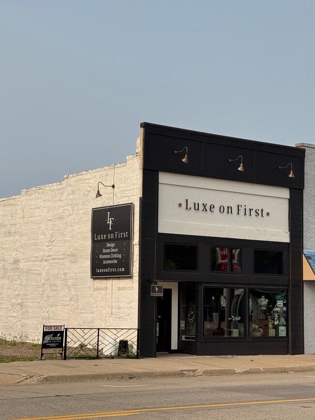
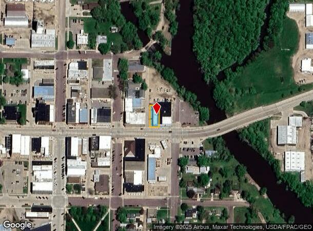
This Property Is For Sale
NEARBY LISTINGS FOR SALE OR LEASE
-
-
View all Rock Rapids listings for sale on LoopNet.com
Property Detail
109 1St Ave
350000000610000
ROCK RAPIDS O. T. S 15' OF W 48 1/2' OF LOT 4, W 48 1/2' OF LOTS 5,6,7 & 8 BLK 2
Storebuilding
Lyon
X
Iowa
19119C0266D
4-8
2024
0.14 AC
2025
Iowa West Area
950200
Other Market Areas
2,376 SF
DEMOGRAPHICS near 109 1St Ave
1 Mile
3 Mile
5 Mile
2024 Total Population
2,874
3,555
3,842
2029 Population
3,299
4,071
4,384
Pop Growth 2024-2029
+ 14.79%
+ 14.51%
+ 14.11%
Average Age
40
40
40
2024 Total Households
1,149
1,402
1,495
HH Growth 2024-2029
+ 14.71%
+ 14.62%
+ 14.18%
Median Household Inc
$73,651
$73,392
$73,373
Avg Household Size
2.40
2.40
2.40
2024 Avg HH Vehicles
2.00
2.00
2.00
Median Home Value
$189,308
$195,068
$201,801
Median Year Built
1970
1971
1970
Nearby Places
- Restaurants
- Banks
- Shops
- Fitness
- Groceries
PUBLIC TRANSPORTATION
AIRPORT
Joe Foss Field
DRIVE
WALK
Distance
Joe Foss Field
55 min
44.6 mi
Nearby Properties
Address
Land Use
TOTAL SIZE
Lot Size
Zoning
Address
Land Use
TOTAL SIZE
Lot Size
Zoning
1,278 SF
24.60 AC
COMM-LGE B
Address
Land Use
TOTAL SIZE
Lot Size
Zoning
5,000 SF
2.73 AC
Address
Land Use
TOTAL SIZE
Lot Size
Zoning
24,448 SF
4.99 AC
COMM-SMALL
Address
Land Use
TOTAL SIZE
Lot Size
Zoning
15,523 SF
1.16 AC
COMM-SMALL
Address
Land Use
TOTAL SIZE
Lot Size
Zoning
1,664 SF
4.33 AC
Address
Land Use
TOTAL SIZE
Lot Size
Zoning
17,670 SF
1.65 AC
COMM-SMALL
Address
Land Use
TOTAL SIZE
Lot Size
Zoning
9,398 SF
4.85 AC
COMM-SMALL
Address
Land Use
TOTAL SIZE
Lot Size
Zoning
22,258 SF
10 AC
COMM-SMALL
Address
Land Use
TOTAL SIZE
Lot Size
Zoning
32,000 SF
11.28 AC
COMM-LGE B
Address
Land Use
TOTAL SIZE
Lot Size
Zoning
38,336 SF
3 AC
COMM-SMALL
Address
Land Use
TOTAL SIZE
Lot Size
Zoning
5,727 SF
11.30 AC
Address
Land Use
TOTAL SIZE
Lot Size
Zoning
11,640 SF
0.99 AC
COMM-SMALL
Address
Land Use
TOTAL SIZE
Lot Size
Zoning
520 SF
1.69 AC
COMM-SMALL
Address
Land Use
TOTAL SIZE
Lot Size
Zoning
18,450 SF
0.32 AC
COMM-SMALL
Address
Land Use
TOTAL SIZE
Lot Size
Zoning
19,500 SF
7 AC
Address
Land Use
TOTAL SIZE
Lot Size
Zoning
28,394 SF
2.73 AC
COMM-SMALL
Address
Land Use
TOTAL SIZE
Lot Size
Zoning
11,127 SF
2.37 AC
Address
Land Use
TOTAL SIZE
Lot Size
Zoning
2,021 SF
1.41 AC
COMM-SMALL
Address
Land Use
TOTAL SIZE
Lot Size
Zoning
3,500 SF
58.40 AC
Address
Land Use
TOTAL SIZE
Lot Size
Zoning
32,720 SF
5.63 AC
COMM-SMALL
Address
Land Use
TOTAL SIZE
Lot Size
Zoning
1,152 SF
2.76 AC
COMM-SMALL
Address
Land Use
TOTAL SIZE
Lot Size
Zoning
6,732 SF
0.21 AC
SINGLE-FAM
Address
Land Use
TOTAL SIZE
Lot Size
Zoning
22,952 SF
2.96 AC
COMM-SMALL
Address
Land Use
TOTAL SIZE
Lot Size
Zoning
3,068 SF
1.06 AC
COMM-SMALL
Address
Land Use
TOTAL SIZE
Lot Size
Zoning
7,955 SF
0.86 AC
COMM-SMALL
Address
Land Use
TOTAL SIZE
Lot Size
Zoning
35,700 SF
5.59 AC
COMM-SMALL
Address
Land Use
TOTAL SIZE
Lot Size
Zoning
4,888 SF
0.61 AC
COMM-SMALL
Address
Land Use
TOTAL SIZE
Lot Size
Zoning
5,425 SF
0.92 AC
Address
Land Use
TOTAL SIZE
Lot Size
Zoning
6,336 SF
0.38 AC
COMM-SMALL
Address
Land Use
TOTAL SIZE
Lot Size
Zoning
1,800 SF
84.54 AC
COMM-SMALL
The World's #1 Commercial Real Estate Marketplace
Connect with us
© 2025 CoStar Group
The information above has been obtained from sources believed reliable. While we do not doubt its accuracy we have not verified it and make no guarantee, warranty or representation about it. It is your responsibility to independently confirm its accuracy and completeness. Any projections, opinions, assumptions, or estimates used are for example only and do not represent the current or future performance of the property. The value of this transaction to you depends on tax and other factors which should be evaluated by your tax, financial, and legal advisors. You and your advisors should conduct a careful, independent investigation of the property to determine to your satisfaction the suitability of the property for your needs.