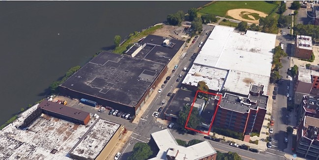
Property Record
109 27Th Ave, Astoria, NY 11102

NEARBY LISTINGS FOR SALE OR LEASE
Property Detail
109 27Th Ave
00915-0038
Queens
Autorepair
New York
AE
39
3604970093F
0.06 AC
2024
Northwest Queens
2025
Long Island (New York)
008700
New York-Jersey City-White Plains, NY-NJ
1,800 SF
DEMOGRAPHICS near 109 27Th Ave
1 Mile
3 Mile
5 Mile
2024 Total Population
155,664
1,185,917
2,937,807
2029 Population
145,295
1,104,382
2,744,868
Pop Growth 2024-2029
(6.66%)
(6.88%)
(6.57%)
Average Age
41
41
40
2024 Total Households
76,332
551,620
1,252,620
HH Growth 2024-2029
(6.99%)
(7.10%)
(6.85%)
Median Household Inc
$93,524
$87,182
$74,270
Avg Household Size
2.00
2.00
2.20
2024 Avg HH Vehicles
.00
.00
.00
Median Home Value
$837,171
$939,441
$820,434
Median Year Built
1962
1956
1955
Nearby Places
- Restaurants
- Banks
- Shops
- Fitness
- Groceries
SALE & LEASE HISTORY
LISTING DATE
SALE/LEASE

Feb 28, 2017
For Sale
Dec 15, 2016
For Sale
Dec 14, 2016
For Sale
Nearby Properties
Address
Land Use
TOTAL SIZE
Lot Size
Zoning
Address
Land Use
TOTAL SIZE
Lot Size
Zoning
2,245,112 SF
2.02 AC
C6-6
Address
Land Use
TOTAL SIZE
Lot Size
Zoning
1,783,434 SF
1.94 AC
C5-3
Address
Land Use
TOTAL SIZE
Lot Size
Zoning
2,636,182 SF
2.35 AC
C65.5
Address
Land Use
TOTAL SIZE
Lot Size
Zoning
5,519,372 SF
409.21 AC
C8-2
Address
Land Use
TOTAL SIZE
Lot Size
Zoning
2,734,038 SF
4.24 AC
C52.5
Address
Land Use
TOTAL SIZE
Lot Size
Zoning
1,678,135 SF
1.01 AC
C5-3
Address
Land Use
TOTAL SIZE
Lot Size
Zoning
1,897,491 SF
2.06 AC
C52.5
Address
Land Use
TOTAL SIZE
Lot Size
Zoning
1,233,684 SF
16.94 AC
PARK
Address
Land Use
TOTAL SIZE
Lot Size
Zoning
1,638,259 SF
1.43 AC
C52.5
Address
Land Use
TOTAL SIZE
Lot Size
Zoning
2,360,627 SF
2.08 AC
C6-7
Address
Land Use
TOTAL SIZE
Lot Size
Zoning
1,642,675 SF
1.05 AC
C6-7
Address
Land Use
TOTAL SIZE
Lot Size
Zoning
1,984,228 SF
1.95 AC
C65.5
Address
Land Use
TOTAL SIZE
Lot Size
Zoning
1,586,876 SF
1.87 AC
C5-3
Address
Land Use
TOTAL SIZE
Lot Size
Zoning
1,962,900 SF
1.89 AC
C66.5
Address
Land Use
TOTAL SIZE
Lot Size
Zoning
1,842,991 SF
2.08 AC
C66.5
Address
Land Use
TOTAL SIZE
Lot Size
Zoning
1,613,847 SF
1.84 AC
C66.5
Address
Land Use
TOTAL SIZE
Lot Size
Zoning
2,215,000 SF
6.43 AC
R9
Address
Land Use
TOTAL SIZE
Lot Size
Zoning
1,596,521 SF
1.34 AC
C6-4
Address
Land Use
TOTAL SIZE
Lot Size
Zoning
2,344,406 SF
1.84 AC
C5-3
Address
Land Use
TOTAL SIZE
Lot Size
Zoning
264,420 SF
7.26 AC
C4-7
Address
Land Use
TOTAL SIZE
Lot Size
Zoning
431,963 SF
C67T
Address
Land Use
TOTAL SIZE
Lot Size
Zoning
1,448,897 SF
1.56 AC
C6-6
Address
Land Use
TOTAL SIZE
Lot Size
Zoning
1,649,604 SF
1.51 AC
C67T
Address
Land Use
TOTAL SIZE
Lot Size
Zoning
2,400,000 SF
15.14 AC
C5-2
Address
Land Use
TOTAL SIZE
Lot Size
Zoning
1,606,528 SF
1.84 AC
C6-6
Address
Land Use
TOTAL SIZE
Lot Size
Zoning
1,169,666 SF
1.42 AC
C52.5
Address
Land Use
TOTAL SIZE
Lot Size
Zoning
1,482,208 SF
1.71 AC
C5-3
Address
Land Use
TOTAL SIZE
Lot Size
Zoning
1,160,500 SF
1.62 AC
C6-6
Address
Land Use
TOTAL SIZE
Lot Size
Zoning
1,642,441 SF
3.26 AC
C52.5
Address
Land Use
TOTAL SIZE
Lot Size
Zoning
2,230,742 SF
6.33 AC
R9
The World's #1 Commercial Real Estate Marketplace
Connect with us
© 2025 CoStar Group
The information above has been obtained from sources believed reliable. While we do not doubt its accuracy we have not verified it and make no guarantee, warranty or representation about it. It is your responsibility to independently confirm its accuracy and completeness. Any projections, opinions, assumptions, or estimates used are for example only and do not represent the current or future performance of the property. The value of this transaction to you depends on tax and other factors which should be evaluated by your tax, financial, and legal advisors. You and your advisors should conduct a careful, independent investigation of the property to determine to your satisfaction the suitability of the property for your needs.