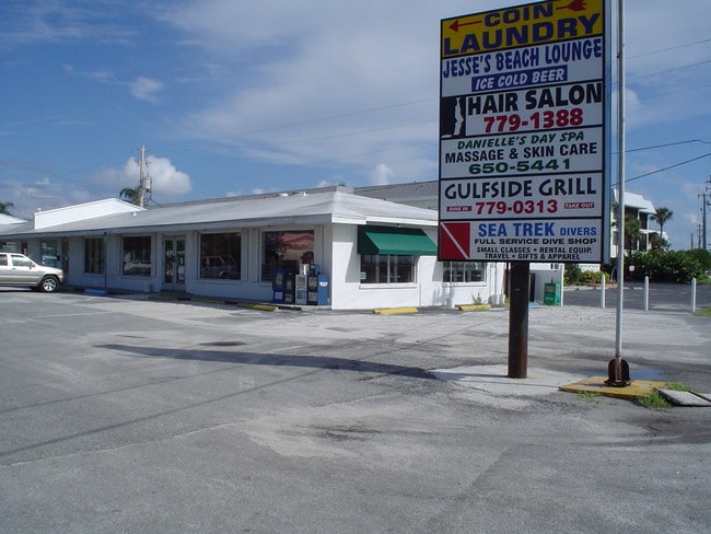
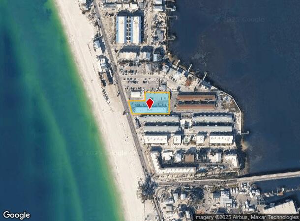
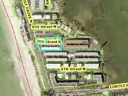
Property Record
101 7Th St N, Bradenton Beach, FL 34217
NEARBY LISTINGS FOR SALE OR LEASE
Property Detail
101 7Th St N
North Port-Sarasota-Bradenton, FL
Acreage
77103-0010-9
(PARCEL A) BEG AT A PT ON THE ELY R/W OF SR 789, 300 FT N OF THE S LN OF U.S. GOVT LOT 1, SEC 4, TWN 35S, RNG 16E; TH S 17 DEG 30 MIN 00 SEC E ALG SD ELY R/W, 94.37 FT TO THE SW
Storemultistory
Manatee
AE
Florida
12081C0277F
1
2024
0.83 AC
2025
Manatee
001701
Tampa/St Petersburg
6,634 SF
DEMOGRAPHICS near 101 7Th St N
1 Mile
3 Mile
5 Mile
2024 Total Population
2,890
13,980
43,444
2029 Population
3,633
17,151
51,977
Pop Growth 2024-2029
+ 25.71%
+ 22.68%
+ 19.64%
Average Age
61
61
56
2024 Total Households
1,611
7,660
21,568
HH Growth 2024-2029
+ 25.08%
+ 21.92%
+ 19.14%
Median Household Inc
$71,470
$71,424
$72,665
Avg Household Size
1.80
1.80
2.00
2024 Avg HH Vehicles
2.00
2.00
2.00
Median Home Value
$547,688
$509,248
$416,965
Median Year Built
1976
1979
1981
Nearby Places
- Restaurants
- Banks
- Shops
- Fitness
- Groceries
PUBLIC TRANSPORTATION
AIRPORT
Sarasota/Bradenton International
DRIVE
WALK
Distance
Sarasota/Bradenton International
26 min
13.2 mi
Freight Ports
Port Manatee
DRIVE
WALK
Distance
Port Manatee
41 min
22.3 mi
Nearby Properties
Address
Land Use
TOTAL SIZE
Lot Size
Zoning
Address
Land Use
TOTAL SIZE
Lot Size
Zoning
14,413 SF
80.01 AC
BB_PRA,BB_
Address
Land Use
TOTAL SIZE
Lot Size
Zoning
268,662 SF
21.35 AC
BR_PDP,BR_
Address
Land Use
TOTAL SIZE
Lot Size
Zoning
87,860 SF
3.36 AC
BR_PDP
Address
Land Use
TOTAL SIZE
Lot Size
Zoning
62,778 SF
6.69 AC
HB_C-3
Address
Land Use
TOTAL SIZE
Lot Size
Zoning
7,250 SF
12.48 AC
RSMH-6
Address
Land Use
TOTAL SIZE
Lot Size
Zoning
28,462 SF
4.36 AC
HB_PSP
Address
Land Use
TOTAL SIZE
Lot Size
Zoning
35,822 SF
1.85 AC
BB_E-1,BB_
Address
Land Use
TOTAL SIZE
Lot Size
Zoning
33,140 SF
13.35 AC
BR_PDP
Address
Land Use
TOTAL SIZE
Lot Size
Zoning
50,662 SF
5.46 AC
HB_PSP
Address
Land Use
TOTAL SIZE
Lot Size
Zoning
11,670 SF
1.17 AC
LBK_R-1SF
Address
Land Use
TOTAL SIZE
Lot Size
Zoning
11,261 SF
9.95 AC
HB_REC
Address
Land Use
TOTAL SIZE
Lot Size
Zoning
28,318 SF
1.65 AC
HB_C-2
Address
Land Use
TOTAL SIZE
Lot Size
Zoning
60,655 SF
1.22 AC
BB_C-2
Address
Land Use
TOTAL SIZE
Lot Size
Zoning
33,565 SF
1.43 AC
GC GENERA
Address
Land Use
TOTAL SIZE
Lot Size
Zoning
52,431 SF
3.06 AC
HB_C-3
Address
Land Use
TOTAL SIZE
Lot Size
Zoning
23,650 SF
2.15 AC
BB_C-2
Address
Land Use
TOTAL SIZE
Lot Size
Zoning
19,150 SF
3.99 AC
HB_C-3
Address
Land Use
TOTAL SIZE
Lot Size
Zoning
12,859 SF
0.79 AC
LBK_C-1
Address
Land Use
TOTAL SIZE
Lot Size
Zoning
29,804 SF
3.29 AC
HB_C-3
Address
Land Use
TOTAL SIZE
Lot Size
Zoning
8,121 SF
2.62 AC
LBK_R-3SF
Address
Land Use
TOTAL SIZE
Lot Size
Zoning
13,888 SF
0.83 AC
RSF-4.5 RE
Address
Land Use
TOTAL SIZE
Lot Size
Zoning
6,889 SF
1.40 AC
LBK_M-1
Address
Land Use
TOTAL SIZE
Lot Size
Zoning
119 AC
BR_PDP
Address
Land Use
TOTAL SIZE
Lot Size
Zoning
53,125 SF
3.53 AC
LBK_C-2
Address
Land Use
TOTAL SIZE
Lot Size
Zoning
5,838 SF
0.99 AC
LBK_R-1SF
Address
Land Use
TOTAL SIZE
Lot Size
Zoning
7,891 SF
0.53 AC
BB_PSP
Address
Land Use
TOTAL SIZE
Lot Size
Zoning
2,214 SF
6.34 AC
RVP
Address
Land Use
TOTAL SIZE
Lot Size
Zoning
38,621 SF
1.22 AC
PD-W
Address
Land Use
TOTAL SIZE
Lot Size
Zoning
35.05 AC
BR_PDP
Address
Land Use
TOTAL SIZE
Lot Size
Zoning
8,688 SF
0.48 AC
BB_R-2,BB_
The World's #1 Commercial Real Estate Marketplace
Connect with us
© 2025 CoStar Group
The information above has been obtained from sources believed reliable. While we do not doubt its accuracy we have not verified it and make no guarantee, warranty or representation about it. It is your responsibility to independently confirm its accuracy and completeness. Any projections, opinions, assumptions, or estimates used are for example only and do not represent the current or future performance of the property. The value of this transaction to you depends on tax and other factors which should be evaluated by your tax, financial, and legal advisors. You and your advisors should conduct a careful, independent investigation of the property to determine to your satisfaction the suitability of the property for your needs.