Property Record
109 Creeper Hill Rd, North Grafton, MA 01536

NEARBY LISTINGS FOR SALE OR LEASE
Property Detail
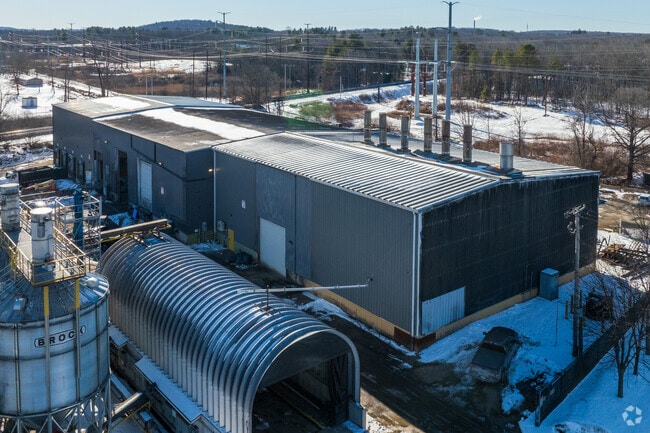
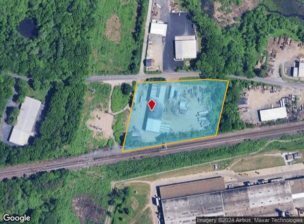
109 Creeper Hill Rd
GRAF-000017-000000-000020
Worcester
Industrialgeneral
Massachusetts
X
2.0
25027C0826E
4.23 AC
2025
Worcester Metro
2025
Boston
761300
Worcester, MA-CT
12,000 SF
DEMOGRAPHICS near 109 Creeper Hill Rd
1 Mile
3 Mile
5 Mile
2024 Total Population
4,735
50,718
188,511
2029 Population
4,767
50,708
187,118
Pop Growth 2024-2029
+ 0.68%
(0.02%)
(0.74%)
Average Age
43
41
38
2024 Total Households
1,911
20,726
73,273
HH Growth 2024-2029
+ 0.63%
+ 0.02%
(0.71%)
Median Household Inc
$99,084
$91,681
$70,773
Avg Household Size
2.40
2.40
2.40
2024 Avg HH Vehicles
2.00
2.00
2.00
Median Home Value
$392,376
$373,470
$380,582
Median Year Built
1968
1971
1960
Nearby Places
Map Layers
Map Styles
 Street
 Aerial
- Restaurants
- Banks
- Shops
- Fitness
- Groceries
PUBLIC TRANSPORTATION
COMMUTER RAIL
Grafton (Framingham/Worcester Line - Massachusetts Bay Transportation Authority Commuter Rail (Purple Line))
DRIVE
WALK
Distance
Grafton (Framingham/Worcester Line - Massachusetts Bay Transportation Authority Commuter Rail (Purple Line))
8 min
3.1 mi
DRIVE
WALK
Distance
8 min
4.5 mi
AIRPORT
Worcester Regional
DRIVE
WALK
Distance
Worcester Regional
20 min
10.3 mi
Freight Ports
Port of Boston
DRIVE
WALK
Distance
Port of Boston
60 min
43.6 mi
SALE & LEASE HISTORY
LISTING DATE
SALE/LEASE

Oct 23, 2024
For Sale
Nearby Properties
Address
Land Use
TOTAL SIZE
Lot Size
Zoning
Address
Land Use
TOTAL SIZE
Lot Size
Zoning
46.50 AC
R4
Address
Land Use
TOTAL SIZE
Lot Size
Zoning
43.07 AC
COM BU
Address
Land Use
TOTAL SIZE
Lot Size
Zoning
16.01 AC
COM BU
Address
Land Use
TOTAL SIZE
Lot Size
Zoning
375.66 AC
OLI
Address
Land Use
TOTAL SIZE
Lot Size
Zoning
176,316 SF
19.57 AC
RL-7
Address
Land Use
TOTAL SIZE
Lot Size
Zoning
70,514 SF
31.64 AC
RL-7
Address
Land Use
TOTAL SIZE
Lot Size
Zoning
210,168 SF
45.75 AC
RL-7
Address
Land Use
TOTAL SIZE
Lot Size
Zoning
203,184 SF
0.21 AC
MF-1
Address
Land Use
TOTAL SIZE
Lot Size
Zoning
27.89 AC
RL-7
Address
Land Use
TOTAL SIZE
Lot Size
Zoning
64.46 AC
RS-7
Address
Land Use
TOTAL SIZE
Lot Size
Zoning
78.19 AC
RL-7
Address
Land Use
TOTAL SIZE
Lot Size
Zoning
154,200 SF
4.87 AC
BL-1
Address
Land Use
TOTAL SIZE
Lot Size
Zoning
7,700 SF
80.72 AC
ML-.5
Address
Land Use
TOTAL SIZE
Lot Size
Zoning
0.99 AC
MF-1 9
Address
Land Use
TOTAL SIZE
Lot Size
Zoning
134,896 SF
15.10 AC
LIM IN
Address
Land Use
TOTAL SIZE
Lot Size
Zoning
99,908 SF
18.28 AC
RUR AA
Address
Land Use
TOTAL SIZE
Lot Size
Zoning
53.52 AC
RL-7
Address
Land Use
TOTAL SIZE
Lot Size
Zoning
55,178 SF
5 AC
COM BU
Address
Land Use
TOTAL SIZE
Lot Size
Zoning
93,092 SF
162.83 AC
OLI
Address
Land Use
TOTAL SIZE
Lot Size
Zoning
15.26 AC
COM BU
Address
Land Use
TOTAL SIZE
Lot Size
Zoning
11.84 AC
COM BU
Address
Land Use
TOTAL SIZE
Lot Size
Zoning
55.79 AC
R4
Address
Land Use
TOTAL SIZE
Lot Size
Zoning
40.46 AC
R4
Address
Land Use
TOTAL SIZE
Lot Size
Zoning
99,600 SF
13.71 AC
RL-7
Address
Land Use
TOTAL SIZE
Lot Size
Zoning
115,564 SF
9.33 AC
RL-7
Address
Land Use
TOTAL SIZE
Lot Size
Zoning
19.76 AC
BL-1
Address
Land Use
TOTAL SIZE
Lot Size
Zoning
57,288 SF
11.95 AC
CB
Address
Land Use
TOTAL SIZE
Lot Size
Zoning
47.94 AC
RL-7
Address
Land Use
TOTAL SIZE
Lot Size
Zoning
84,672 SF
17.85 AC
COM BU
Address
Land Use
TOTAL SIZE
Lot Size
Zoning
1,628 SF
7.06 AC
The World's #1 Commercial Real Estate Marketplace
Connect with us
© 2026 CoStar Group
The information above has been obtained from sources believed reliable. While we do not doubt its accuracy we have not verified it and make no guarantee, warranty or representation about it. It is your responsibility to independently confirm its accuracy and completeness. Any projections, opinions, assumptions, or estimates used are for example only and do not represent the current or future performance of the property. The value of this transaction to you depends on tax and other factors which should be evaluated by your tax, financial, and legal advisors. You and your advisors should conduct a careful, independent investigation of the property to determine to your satisfaction the suitability of the property for your needs.